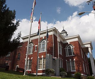
Clintwood, Virginia

Last updated

Clintwood, Virginia
Clintwood-from-McClure-va.jpg
Clintwood
Seal of Clintwood, Virginia.png
Motto: 
"The county seat of Virginia's baby" [1]
VAMap-doton-Clintwood.PNG
Location of Clintwood, Virginia
Coordinates: 37°9′0″N82°27′24″W / 37.15000°N 82.45667°W / 37.15000; -82.45667
CountryUnited States
State Virginia
County Dickenson
Founded by John Wesley Mullins Jr
Government
  Mayor Danny Lambert
  SheriffJeremy Fleming
Area
[2]
  Total2.08 sq mi (5.39 km2)
  Land2.08 sq mi (5.39 km2)
  Water0.00 sq mi (0.01 km2)
Elevation
1,755 ft (535 m)
Population
 (2010)
  Total1,414
  Estimate 
(2019) [3]
1,284
  Density617.31/sq mi (238.37/km2)
Time zone UTC−5 (Eastern (EST))
  Summer (DST) UTC−4 (EDT)
ZIP code
24228
Area code 276
FIPS code 51-17552 [4]
GNIS feature ID1498468 [5]
Website www.townofclintwood.com

Clintwood is a town in Dickenson County, Virginia, United States. The population was 1,377 at the 2020 census. [6] It is the county seat of Dickenson County. [7]

Contents

Although originally called "Holly Creek" after a small stream that runs through the town, it was later named "Clintwood" after Major Henry Clinton Wood, a Confederate officer in the 37th Virginia Infantry Regiment. [8]

History

Clintwood, Virginia was founded in 1829 by John "Holly Creek John" Mullins. [9] In June 1948, the town of Clintwood elected an all-female town council for the period from 1948 to 1950. The "Petticoat Government", as it was nicknamed, implemented change in many areas, including cleanup of the town, eliminating parking problems, organizing a systematic garbage disposal system, eliminating several traffic hazards, organizing the town's fire department, and purchasing a fire truck. The "Petticoat Government" received the attention of Lady Astor, a member of the British Parliament who expressed a desire to visit Clintwood to see how the experiment was going. The town was also featured in broadcasts by the Voice of America. [10] [11]

Geography

Clintwood is located in northwestern Dickenson County at 37°9′0″N82°27′24″W / 37.15000°N 82.45667°W / 37.15000; -82.45667 (37.150054, −82.456698). [12] Virginia State Route 83 passes through the town, leading east 11 miles (18 km) to Clinchco and west 9 miles (14 km) to Pound.

According to the United States Census Bureau, Clintwood has a total area of 1.9 square miles (4.9 km2), all of it land. [13]

Climate

Owing to its altitude, Clintwood has an oceanic climate (Köppen climate classification Cfb).

Climate data for Clintwood, Virginia (1991–2020 normals, extremes 1993–present)
MonthJanFebMarAprMayJunJulAugSepOctNovDecYear
Record high °F (°C)76
(24)
78
(26)
85
(29)
90
(32)
92
(33)
97
(36)
97
(36)
95
(35)
94
(34)
89
(32)
82
(28)
73
(23)
97
(36)
Mean daily maximum °F (°C)42.5
(5.8)
46.5
(8.1)
55.9
(13.3)
67.5
(19.7)
74.1
(23.4)
79.5
(26.4)
81.8
(27.7)
80.7
(27.1)
75.9
(24.4)
66.4
(19.1)
55.4
(13.0)
45.5
(7.5)
64.3
(17.9)
Daily mean °F (°C)32.1
(0.1)
35.3
(1.8)
42.7
(5.9)
52.5
(11.4)
60.9
(16.1)
67.7
(19.8)
71.2
(21.8)
70.3
(21.3)
64.3
(17.9)
53.1
(11.7)
42.6
(5.9)
35.4
(1.9)
52.3
(11.3)
Mean daily minimum °F (°C)21.7
(−5.7)
24.1
(−4.4)
29.4
(−1.4)
37.6
(3.1)
47.8
(8.8)
55.9
(13.3)
60.7
(15.9)
59.9
(15.5)
52.8
(11.6)
39.9
(4.4)
29.7
(−1.3)
25.3
(−3.7)
40.4
(4.7)
Record low °F (°C)−19
(−28)
−23
(−31)
0
(−18)
18
(−8)
28
(−2)
36
(2)
45
(7)
41
(5)
31
(−1)
20
(−7)
8
(−13)
−4
(−20)
−23
(−31)
Average precipitation inches (mm)3.72
(94)
3.91
(99)
4.42
(112)
4.56
(116)
4.94
(125)
5.12
(130)
5.31
(135)
4.06
(103)
3.25
(83)
2.83
(72)
2.80
(71)
4.25
(108)
49.17
(1,249)
Average snowfall inches (cm)11.5
(29)
10.5
(27)
6.6
(17)
0.8
(2.0)
0.0
(0.0)
0.0
(0.0)
0.0
(0.0)
0.0
(0.0)
0.0
(0.0)
0.3
(0.76)
1.1
(2.8)
7.6
(19)
38.4
(98)
Average precipitation days (≥ 0.01 in)15.514.814.813.514.914.314.212.09.610.511.814.9160.8
Average snowy days (≥ 0.1 in)7.76.74.20.90.00.00.00.00.00.21.75.426.8
Source: NOAA [14] [15]

Demographics

Historical population
CensusPop.Note
1900 255
1910 34234.1%
1920 40017.0%
1930 72982.3%
1940 1,10651.7%
1950 1,36623.5%
1960 1,4002.5%
1970 1,320−5.7%
1980 1,3693.7%
1990 1,54212.6%
2000 1,5490.5%
2010 1,414−8.7%
2019 (est.)1,284 [3] −9.2%
U.S. Decennial Census [16]

As of the census [4] of 2000, there were 1,549 people, 672 households, and 426 families residing in the town. The population density was 812.0 people per square mile (313.5 people/km2). There were 756 housing units at an average density of 396.3 per square mile (153.0/km2). The racial makeup of the town was 98.52% White, 0.19% African American, 0.19% Native American, 0.13% Asian, and 0.97% from two or more races. Hispanic or Latino of any race were 0.52% of the population.

There were 672 households, out of which 21.9% had children under the age of 18 living with them, 44.8% were married couples living together, 15.5% had a female householder with no husband present, and 36.5% were non-families. 33.8% of all households were made up of individuals, and 17.7% had someone living alone who was 65 years of age or older. The average household size was 2.10 and the average family size was 2.65.

In the town, the population was spread out, with 16.5% under the age of 18, 8.3% from 18 to 24, 23.2% from 25 to 44, 27.8% from 45 to 64, and 24.3% who were 65 years of age or older. The median age was 46 years. For every 100 females, there were 84.4 males. For every 100 females age 18 and over, there were 81.5 males.

The median income for a household in the town was $22,663, and the median income for a family was $30,833. Males had a median income of $29,844 versus $21,250 for females. The per capita income for the town was $16,323. About 16.0% of families and 21.6% of the population were below the poverty line, including 30.5% of those under age 18 and 16.7% of those age 65 or over.

Education

Industry

Recreation

Area attractions

Notable persons

Singer, songwriter and multi-instrumentalist Mark Linkous (Sparklehorse) has family ties to Clintwood, and for a short time called Clintwood home.

Justin Hamilton was a former star at Clintwood High School, defensive back for the Virginia Tech Hokies and former member of the National Football League's Cleveland Browns and Washington Redskins football organizations.

Bluegrass musician Ralph Stanley was from Dickenson County and lived on Sandy Ridge in the mountains that surround Clintwood. A museum honoring his musical legacy is located in the historic district of downtown.

Related Research Articles

<span class="mw-page-title-main">Dickenson County, Virginia</span> County in Virginia, United States

Dickenson County is a county located in the Commonwealth of Virginia. As of the 2020 census, the population was 14,124. Its county seat is Clintwood.

<span class="mw-page-title-main">Buchanan County, Virginia</span> County in Virginia, United States

Buchanan County is a United States county in far western Virginia, the only county in the state to border both West Virginia and Kentucky. The county is part of the Southwest Virginia region and lies in the rugged Appalachian Plateau portion of the Appalachian Mountains. Its county seat is Grundy.

<span class="mw-page-title-main">Pierson, Florida</span> Town in the state of Florida, United States

Pierson is a town in Volusia County, Florida, United States. The town is part of the Deltona–Daytona Beach–Ormond Beach, Florida Metropolitan Statistical Area. The population was 1,542 as of the 2020 census.

<span class="mw-page-title-main">Roopville, Georgia</span> Town in Georgia, United States

Roopville is a town in Carroll County, Georgia, United States. The population was 218 at the 2010 census.

<span class="mw-page-title-main">Oakfield, Maine</span> Town in the state of Maine, United States

Oakfield is a town in Aroostook County, Maine, United States. The population was 661 at the 2020 census. The village of Oakfield, listed as a census-designated place, is in the northwestern corner of the town.

Gray is a census-designated place (CDP) in Washington County, Tennessee, United States and a suburb of Johnson City. It is part of the Johnson City Metropolitan Statistical Area, which is a component of the Johnson City–Kingsport–Bristol, TN-VA Combined Statistical Area – commonly known as the "Tri-Cities" region. The population was 1,222 at the 2010 census.

<span class="mw-page-title-main">Clinchco, Virginia</span> Town in Virginia, United States

Clinchco is a town in Dickenson County, Virginia, United States. The town, formerly known as Moss, was named for both the Clinchfield Railroad and the Clinchfield Coal Corporation. The population was 337 at the 2010 census, down from 424 at the 2000 census. The Clinchco post office was established in 1917.

<span class="mw-page-title-main">Haysi, Virginia</span> Town in Virginia, United States

Haysi is a town in Dickenson County, Virginia, United States. The population was 498 at the 2010 census, up from 186 at the 2000 census, over which time period the town's area tripled.

<span class="mw-page-title-main">Pearisburg, Virginia</span> Town in Virginia, United States

Pearisburg is a town in Giles County, Virginia, and the county seat. The population was 2,909 at the time of the 2020 census. Pearisburg is part of the Blacksburg–Christiansburg Metropolitan Statistical Area.

<span class="mw-page-title-main">Monterey, Virginia</span> Town in Virginia, United States

Monterey is a town in Highland County, Virginia, United States. The population was 165 at the 2020 census. It is the county seat of Highland County.

<span class="mw-page-title-main">Pennington Gap, Virginia</span> Town in Virginia, United States

Pennington Gap is a town in Lee County, Virginia, United States. The population was 1,624 at the 2020 census.

<span class="mw-page-title-main">Cheriton, Virginia</span> Town in Virginia, United States

Cheriton is a town in Northampton County, Virginia, United States. The population was 486 at the 2020 census.
<span class="mw-page-title-main">Lebanon, Virginia</span> Town in Virginia, United States

Lebanon is a town in Russell County, Virginia, United States. The population was 3,424 at the 2010 census. It is the county seat of Russell County.

<span class="mw-page-title-main">Tazewell, Virginia</span> Town in Virginia, United States

Tazewell is a town in Tazewell County, Virginia, United States. The population was 4,627 at the 2010 census. It is part of the Bluefield, WV-VA micropolitan area, which has a population of 107,578. It is the county seat of Tazewell County.
<span class="mw-page-title-main">Glenville, West Virginia</span> Town in West Virginia, United States

Glenville is a town in and the county seat of Gilmer County, West Virginia, United States, along the Little Kanawha River. The population was 1,128 at the 2020 census. It is the home of Glenville State University.

<span class="mw-page-title-main">Petersburg, West Virginia</span> City in West Virginia, United States

Petersburg is a city in Grant County, West Virginia, United States. The population was 2,251 at the 2020 census. It is the county seat of Grant County.
<span class="mw-page-title-main">Henderson, West Virginia</span> Unincorporated Town in West Virginia, United States

Henderson is an unincorporated community and former town in Mason County, West Virginia, United States, at the confluence of the Ohio and Kanawha Rivers. The population was 231 at the 2020 census. It is part of the Point Pleasant, WV–OH Micropolitan Statistical Area. The town was incorporated in 1893 and named for Samuel Bruce Henderson, who owned the townsite at the time. The town was unincorporated following a public hearing on August 11, 2022.

<span class="mw-page-title-main">Granville, West Virginia</span> Town in West Virginia

Granville is a town in Monongalia County, West Virginia, United States. The population was 1,355 at the 2020 census. It is included in the Morgantown metropolitan area.

<span class="mw-page-title-main">Huttonsville, West Virginia</span> Town in West Virginia, United States

Huttonsville is a town in Randolph County, West Virginia, United States, along the Tygart Valley River. The population was 163 at the 2020 census.
<span class="mw-page-title-main">Smithfield, West Virginia</span> Town in West Virginia, United States

Smithfield is a town in Wetzel County, West Virginia, United States. The population was 103 at the 2020 census.

References

  1. Town of Clintwood official website
  2. "2019 U.S. Gazetteer Files". United States Census Bureau. Retrieved August 7, 2020.
  3. 1 2 "Population and Housing Unit Estimates". United States Census Bureau. May 24, 2020. Retrieved May 27, 2020.
  4. 1 2 "U.S. Census website". United States Census Bureau . Retrieved January 31, 2008.
  5. "US Board on Geographic Names". United States Geological Survey. October 25, 2007. Retrieved January 31, 2008.
  6. "Explore Census Data". data.census.gov. Retrieved April 30, 2024.
  7. "Find a County". National Association of Counties. Archived from the original on May 31, 2011. Retrieved June 7, 2011.
  8. Tennis, Joe (2004). Southwest Virginia Crossroads: An Almanac of Place Names and Places to See. The Overmountain Press. p. 6. ISBN   978-1-57072-256-1.
  9. "About Us". Town of Clintwood. Retrieved August 6, 2022.
  10. Little, Herb (June 27, 1948). "Virginia Town's Males Vote in Petticoat Rule". Asheville Citizen-Times . Asheville, North Carolina. p. 2-B. Archived from the original on November 20, 2018. Retrieved November 20, 2018 via newspapers.com.
  11. Short, Martha (February 14, 2000). "Petticoat Government". Archived from the original on June 12, 2008.
  12. "US Gazetteer files: 2010, 2000, and 1990". United States Census Bureau. February 12, 2011. Retrieved April 23, 2011.
  13. "Geographic Identifiers: 2010 Demographic Profile Data (G001): Clintwood town, Virginia". American Factfinder. U.S. Census Bureau. Archived from the original on February 13, 2020. Retrieved January 13, 2016.
  14. "NowData – NOAA Online Weather Data". National Oceanic and Atmospheric Administration. Retrieved June 28, 2021.
  15. "Station: Clintwood 1W, VA". U.S. Climate Normals 2020: U.S. Monthly Climate Normals (1991-2020). National Oceanic and Atmospheric Administration. Retrieved June 28, 2021.
  16. "Census of Population and Housing". Census.gov. Retrieved June 4, 2015.