Hillsboro, Loudoun County, Virginia

Last updated

Hillsboro, Virginia
Town of Hillsboro
Hillsboro, VA.jpg
Charles Town Pike (Virginia State Route 9) in Hillsboro
USA Virginia Northern location map.svg
Red pog.svg
Hillsboro
USA Virginia location map.svg
Red pog.svg
Hillsboro
Usa edcp location map.svg
Red pog.svg
Hillsboro
Coordinates: 39°11′54″N77°43′28″W / 39.19833°N 77.72444°W / 39.19833; -77.72444
CountryFlag of the United States.svg  United States
State Flag of Virginia.svg  Virginia
County Loudoun
Area
[1]
  Total0.27 sq mi (0.69 km2)
  Land0.27 sq mi (0.69 km2)
  Water0.00 sq mi (0.01 km2)
Elevation
551 ft (168 m)
Population
 (2020) [2]
  Total114
  Density430.2/sq mi (166.1/km2)
Time zone UTC−5 (Eastern (EST))
  Summer (DST) UTC−4 (EDT)
ZIP codes
20132, 20134
Area code 540
FIPS code 51-37288 [3]
GNIS feature ID1499563 [4]
Website www.hillsborova.gov

Hillsboro is a rural town in Loudoun County, Virginia, United States. The population was 114 at the 2020 census. [2]

Contents

Geography

Hillsboro is located in western Loudoun County at 39°11′54″N77°43′28″W / 39.19833°N 77.72444°W / 39.19833; -77.72444 (39.198347, 77.724391), [5] at the east end of Hillsboro Gap, where the North Fork of Catoctin Creek breaks through Short Hill Mountain, part of the Blue Ridge Mountains of Virginia. The town is 4 miles (6 km) east of the West Virginia border and 11 miles (18 km) northwest of Leesburg, the Loudoun county seat.

According to the United States Census Bureau, the town has a total area of 0.27 square miles (0.7 km2), all of it land. [1]

SR 9 in Hillsboro 2018-10-18 15 23 42 View east along Virginia State Route 9 (Charles Town Pike) at Hillsboro Road (Virginia State Route 690) in Hillsboro, Loudoun County, Virginia.jpg
SR 9 in Hillsboro

Transportation

Virginia State Route 9 (Charles Town Pike) is the only primary highway passing through Hillsboro. SR 9 extends northwest 12 miles (19 km) to Charles Town and 26 miles (42 km) to Martinsburg, West Virginia, also connecting with Interstate 81. To the southeast, SR 9 connects with Virginia State Route 7, which continues southeastward to Leesburg and Alexandria. Between Leesburg and Alexandria, SR 7 interchanges with Interstate 495, Interstate 66, and Interstate 395.

Demographics

Historical population
CensusPop.Note
1870 246
1880 137−44.3%
1890 15613.9%
1900 131−16.0%
1910 1385.3%
1920 131−5.1%
1930 119−9.2%
1940 115−3.4%
1950 12912.2%
1960 124−3.9%
1970 1358.9%
1980 115−14.8%
1990 72−37.4%
2000 9633.3%
2010 80−16.7%
2020 11442.5%
U.S. Decennial Census [6]

As of the census [3] of 2000, there were 96 people, 39 households, and 28 families residing in the town. The population density was 1,017.9 inhabitants per square mile (393.0/km2). There were 41 housing units at an average density of 434.7 per square mile (175.9/km2). The racial makeup of the town was 96.88% White, and 3.12% African American.

There were 39 households, out of which 28.2% had children under the age of 18 living with them, 64.1% were married couples living together, 5.1% had a female householder with no husband present, and 28.2% were non-families. 20.5% of all households were made up of individuals, and 15.4% had someone living alone who was 65 years of age or older. The average household size was 2.46 and the average family size was 2.75.

In the town, the population was spread out, with 19.8% under the age of 18, 8.3% from 18 to 24, 28.1% from 25 to 44, 30.2% from 45 to 64, and 13.5% who were 65 years of age or older. The median age was 41 years. For every 100 females, there were 84.6 males. For every 100 females age 18 and over, there were 92.5 males.

The median income for a household in the town was $54,375, and the median income for a family was $71,875. Males had a median income of $60,833 versus $27,250 for females. The per capita income for the town was $44,455. There were 11.1% of families and 10.0% of the population living below the poverty line, including 25.0% of under eighteens and none of those over 64.

History, culture and notes

Hillsboro originally spelled "Hillsborough,” lies in the Hillsboro Gap of Short Hill Mountain, which is part of the Blue Ridge Mountains in northwestern Virginia. The town is about 50 miles (80 km) northwest of downtown Washington, D.C. and 10 miles (16 km) south of Harpers Ferry, West Virginia.

Early settlement in this area was stimulated by the growth of population in Pennsylvania of Germans and Quakers seeking religious freedom. Looking south for new, fertile lands to farm, many Quaker families migrated to the Loudoun area and had a significant impact on its development. The first record of settlement in the Hillsboro area, then referred to as the Gap, is dated 1746. Records of twice monthly meetings of the Gap Quakers, held in one of the houses, date to 1755. [7]

Although there were mills and houses in the Gap in the late 1700s, the town of Hillsboro (spelled Hillsborough until its 1880 incorporation) was not formally established until December 31, 1802 by an act passed by the Virginia General Assembly. The trustees of Hillsboro named in the act were Mahlon Hough, Samuel Purcell, Jr., Thomas Leslie, Josiah White, Jr., Edward Cunard, Mahlon Roach, and Thomas D. Stevens. By June 20, 1811, when Henry Griffin bought lot No. 12 on the town plat at auction for $88.50 paid to the trustees, he was required to build ‘a House thereon Twelve feet Square or equal thereto with a Stone or Brick Chimney to the same and a Shingle Roof on it within Four years of the Day of the Sale of the said lott.’ Due to its favorable location on the Vestal's Gap Road, the town grew quickly and in the early 1800s was one of the leading trade centers of western Loudoun, along with Snickerville (Bluemont) and Woodgrove, which has since disappeared. Much of Hillsboro's activity was due to its mills, with as many as five operating at one time, all on Catoctin Creek or its nearby branches. [8] [9]

A row of nineteenth century houses in Hillsboro 19 Century Houses in Hillsboro.jpg
A row of nineteenth century houses in Hillsboro

During this period there typically were three or four doctors in town, five or six general stores, a large tanyard and cooper shop, two shoemakers and three taverns. Two blacksmiths, two saddle and harness makers, two wagon makers and a livery stable tended to the needs found in the horsepowered era. Seamstresses and tailors made clothes from the yarn goods produced by the Gaver woolen mill.

However, the newly constructed railroads and turnpikes bypassed Hillsboro, drawing trade and commerce away from the town. The Civil War events, including the Burning Raid of 1864, devastated the area. During the post-Civil War period, Hillsboro began its transformation from a busy commercial center to a primarily residential community. Homes formerly housing taverns, shops and stores gradually became residences. With the turn of the 20th century, virtually all of the currently existing structures within the town had been built and little has been altered in the majority of the structures since then. [7]

Until 2000 there were no street addresses for the buildings in town; the 60-odd buildings in Hillsboro were referred to by their owners' names or their purposes.

Old Stone School in Hillsboro Old Stone School in Hillsboro, VA.jpg
Old Stone School in Hillsboro

A central feature of the town is its Old Stone School. Originally named Locust Grove Academy, the oldest part of the building, the east wing, was built in 1874. The academy's first principal was Mrs. J.B. White. The Old Stone School, as it is referred to now, is situated at the eastern entrance to the town on Route 9. The stone structure was completed in 1917 with the addition of more rooms on the west side. A junior high school was established there in 1918 and operated for 17 years, until 1935. The brick auditorium was added in 1929. Classes for grades one through seven were taught there until the spring of 1966, when Hillsboro Elementary opened. The school was the hub of the community in the early 1900s. Community plays were frequently held there with a local orchestra that played during intermission.

Located next to the Old Stone School is Hillsboro Charter Academy, which opened in 2016 inside the former Hillsboro Elementary. [10]

The Hillsboro Historic District was placed on the National Register of Historic Places on May 7, 1979. [11]

In 2015, Hillsboro was the third smallest town in Virginia in population. [12]

On December 28, 2016, the town limits officially tripled to 172 acres (70 ha). [13] The zoning change brought the Old Stone School inside the town limits for the first time.

In June 2021, Hillsboro completed ReThink9, a $30 million infrastructure project which included creating two roundabouts on State Route 9 east and west of the town, traffic-calming streetscaping, burial of all overhead utilities, a new safe drinking water system, wastewater management infrastructure as well as an underground stormwater management system. [14]

Notable people

Susan Koerner Wright plaque on Charles Town Pike in Hillsboro Susan Wright plaque Hillsboro.jpg
Susan Koerner Wright plaque on Charles Town Pike in Hillsboro

Susan Koerner Wright, the mother of the Wright brothers, was born near Hillsboro. [15]

Author Byron Farwell was mayor of the town for three terms from 1976 to 1982; [16] other mayors included Sandy Muir and Alix Spaith.

The family of Mary Virginia Gaver, a leader in library science, owned and operated Gaver Woolen Mill in Hillsboro in the 1800s.

Related Research Articles

<span class="mw-page-title-main">Loudoun County, Virginia</span> County in Virginia, United States

Loudoun County is in the northern part of the Commonwealth of Virginia in the United States. In 2020, the census returned a population of 420,959, making it Virginia's third-most populous county. The county seat is Leesburg. Loudoun County is part of the Washington–Arlington–Alexandria, DC–VA–MD–WV Metropolitan Statistical Area. As of 2020, Loudoun County had a median household income of $147,111. Since 2008, the county has been ranked first in the U.S. in median household income among jurisdictions with a population of 65,000 or more.

<span class="mw-page-title-main">Highland County, Ohio</span> County in Ohio, United States

Highland County is a county located in the U.S. state of Ohio. As of the 2020 census, the population was 43,317. Its county seat is Hillsboro. The county is named for the topography which is hilly and divides the watersheds of the Little Miami and Scioto Rivers.

<span class="mw-page-title-main">Centreville, Virginia</span> Census-designated Place in Virginia, United States

Centreville is a census-designated place (CDP) in Fairfax County, Virginia, United States. It is a suburb of Washington, D.C., the nation's capital. It had a population of 73,518, making it the most-populous community in Fairfax County as of the 2020 U.S. census

<span class="mw-page-title-main">Hamilton, Virginia</span> Town in Virginia

Hamilton is a town in the Loudoun Valley of Loudoun County, Virginia, United States. The population was 506 as of the 2010 census.

<span class="mw-page-title-main">Leesburg, Virginia</span> Town in Virginia, United States

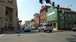
Leesburg is a town in and the county seat of Loudoun County, Virginia, United States. Its is part of both the Northern Virginia region of the state and the Washington metropolitan area, including Washington, D.C., the nation's capital.Settlement in the area began around 1740, which is named for the Lee family, early leaders of the town. Located in the far northeast of the state, in the War of 1812 it was a refuge for important federal documents evacuated from Washington, DC, and in the Civil War, it changed hands several times.

<span class="mw-page-title-main">Lovettsville, Virginia</span> Town in Virginia

Lovettsville is a town in Loudoun County, located near the very northern tip of the Commonwealth of Virginia, United States. Settled primarily by German immigrants, the town was originally established in 1836.

<span class="mw-page-title-main">Purcellville, Virginia</span> Town in Virginia, US

Purcellville is a town in Loudoun County, Virginia. The population was 8,929 according to the 2020 Census. Purcellville is the major population center for Western Loudoun and the Loudoun Valley. Many of the older structures remaining in Purcellville reflect the Victorian architecture popular during the early twentieth century.

<span class="mw-page-title-main">Round Hill, Loudoun County, Virginia</span> Town in Virginia

Round Hill is a town in Loudoun County, Virginia, United States. Its population was 693 at the 2020 census. The town is located at the crossroads of Virginia Routes 7 and 719, approximately 50 miles (80 km) northwest of Washington, D.C. The town's name refers a hill two miles northeast of a 910-foot (280 m) hill used during the American Civil War as a signal post by both Confederate and Union troops. House of Round Hill was built in 2004. Patsy Cline went to Round Hill Elementary School.

<span class="mw-page-title-main">Ashburn, Virginia</span> Census-designated place in Virginia, United States

Ashburn is a rapidly growing census-designated place (CDP) in Loudoun County, Virginia, United States. At the 2010 United States census, its population was 43,511, up from 3,393 in 1990. It is 30 miles (48 km) northwest of Washington, D.C., and part of the Washington metropolitan area.

<span class="mw-page-title-main">Catoctin Mountain</span> Mountain ridge in the United States

Catoctin Mountain, along with the geologically associated Bull Run Mountains, forms the easternmost mountain ridge of the Blue Ridge Mountains, which are in turn a part of the Appalachian Mountains range. The ridge runs northeast–southwest for about 50 miles (80 km) departing from South Mountain near Emmitsburg, Maryland, and running south past Leesburg, Virginia, where it disappears into the Piedmont in a series of low-lying hills near New Baltimore, Virginia. The ridge forms the eastern rampart of the Loudoun and Middletown valleys.

<span class="mw-page-title-main">Waterford, Virginia</span> Unincorporated community in Virginia, United States

Waterford is a unique place of historic significance. The entire village and surrounding countryside is a National Historic Landmark District, noted for its well-preserved 18th and 19th-century character. It is an unincorporated village and census-designated place (CDP) in the Catoctin Valley of Loudoun County, Virginia, located along Catoctin Creek. Waterford is 47 miles (76 km) northwest of Washington, D.C., and 7 miles (11 km) northwest of Leesburg.

Taylorstown is a small community in Loudoun County, Virginia, built on the banks of Catoctin Creek and the surrounding hillside, about two miles (3 km) south of the Potomac River. First settled in 1734, it holds two of the oldest standing houses in Loudoun County, "Hunting Hill" and "Foxton Cottage", directly across the Catoctin Creek from each other.

Stone Ridge is a census-designated place in Loudoun County, Virginia, United States. Residences use Aldie mailing addresses, and it is near Washington Dulles International Airport. The population as of the 2020 census was 15,039. Stone Ridge is a Van Metre Homes planned, mixed-use community.

<span class="mw-page-title-main">Loudoun Valley</span> Valley in northern Virginia

The Loudoun Valley is a small, but historically significant valley in the Blue Ridge Mountains located in Loudoun County in Northern Virginia in the United States.

<span class="mw-page-title-main">Goose Creek (Potomac River tributary)</span> River in Virginia, United States

Goose Creek is a 53.9-mile-long (86.7 km) tributary of the Potomac River in Fauquier and Loudoun counties in northern Virginia. It comprises the principal drainage system for the Loudoun Valley.

<span class="mw-page-title-main">Broadlands, Virginia</span> Census-designated place in Virginia

Broadlands is a census-designated place (CDP) in Loudoun County, Virginia, United States. It is a 1,500-acre (610 ha) master-planned community started and developed by Van Metre Homes in the 1990s. It is built on wetlands and is certified as a Community Wildlife Habitat by the National Wildlife Federation.

Between the Hills is a small valley in northwest Loudoun County, Virginia, distinct from, but associated with, the greater Loudoun Valley.

<span class="mw-page-title-main">Dranesville, Virginia</span> Census-designated place in Virginia, United States

Dranesville is a census-designated place (CDP) in Fairfax County, Virginia, United States. Dranesville is located on the Leesburg Pike at its intersection with Georgetown Pike. The U.S. Census Bureau defines Dranesville as a census-designated place (CDP) with a population of 11,921 as of 2010. At the 2020 Census the population was 11,785.

Loudoun County, Virginia, was destined to be an area of significant military activity during the American Civil War. Located on Virginia's northern frontier, the Potomac River, Loudoun County became a borderland after Virginia's secession from the Union in early 1861. Loudoun County's numerous Potomac bridges, ferries and fords made it an ideal location for the Union and Confederate armies to cross into and out of Virginia. Likewise, the county's several gaps in the Blue Ridge Mountains that connected the Piedmont to the Shenandoah Valley and Winchester were of considerable strategic importance. The opposing armies would traverse the county several times throughout the war leading to several small battles, most notably the Battle of Ball's Bluff.

<span class="mw-page-title-main">Virginia State Route 9</span> State highway in Loudoun County, Virginia, US

Virginia State Route 9 is a primary state highway in the U.S. state of Virginia. Known as Charles Town Pike, the state highway runs 13.08 miles (21.05 km) from the West Virginia state line near Mechanicsville, where the highway continues west as West Virginia Route 9, east to SR 7 and SR 7 Business in Paeonian Springs. SR 9 is the main east–west highway of northwestern Loudoun County, connecting Leesburg with Hillsboro and the West Virginia cities of Charles Town and Martinsburg. As a result, the state highway and its West Virginia continuation are a major, overburdened commuter route between the Eastern Panhandle of West Virginia and Washington, D.C.

References

  1. 1 2 "2020 U.S. Gazetteer Files –Virginia". United States Census Bureau. Retrieved February 17, 2021.
  2. 1 2 "Profile of General Population and Housing Characteristics: 2020 Demographic Profile Data (DP-1): Hillsboro town, Virginia". United States Census Bureau . Retrieved March 19, 2024.
  3. 1 2 "American FactFinder". United States Census Bureau. Archived from the original on February 12, 2020. Retrieved January 31, 2008.
  4. "US Board on Geographic Names". United States Geological Survey. October 25, 2007. Retrieved January 31, 2008.
  5. "US Gazetteer files: 2010, 2000, and 1990". United States Census Bureau. February 12, 2011. Retrieved April 23, 2011.
  6. "Census of Population and Housing". Census.gov. Archived from the original on April 26, 2015. Retrieved June 4, 2015.
  7. 1 2 "Archived copy" (PDF). Archived from the original (PDF) on June 22, 2018. Retrieved January 28, 2019.{{cite web}}: CS1 maint: archived copy as title (link)
  8. Hillsboro, Memories of a Mill Town
  9. "Hillsboro, Virginia 200 Years Later | History of Loudoun County, Virginia" . Retrieved October 8, 2019.
  10. "What is HCA?". Hillsboro Charter Academy. May 14, 2014. Retrieved May 9, 2017.
  11. "National Register Information System". National Register of Historic Places . National Park Service. March 13, 2009.
  12. City and Town Population Totals Datasets:<rc-c2d-number> 2010-2015</rc-c2d-number>: Virginia, United States Census Bureau
  13. Morton, Margaret (January 5, 2017). "Hillsboro Expansion Sets Stage for Bigger Things". Loudoun Now. Retrieved May 9, 2017.
  14. "Northern Virginia's Smallest Town Completes $30 Million Infrastructure Project". rethink9.com. June 21, 2021. Retrieved June 29, 2021.
  15. The Wright Family Wright Brothers Aeroplane Company/Information Desk
  16. Duran, Estela (August 7, 1999). "Byron Farwell, 78, Is Dead; Historian and Virginia Mayor". The New York Times. ISSN   0362-4331 . Retrieved December 29, 2020.