Drakes Branch, Virginia

Last updated
Drakes Branch, Virginia
Drakes Branch 47.jpg
Seal of Drakes Branch, Virginia.png
VAMap-doton-DrakesBranch.PNG
Location of Drakes Branch, Virginia
Coordinates: 36°59′35″N78°36′6″W / 36.99306°N 78.60167°W / 36.99306; -78.60167
Country United States
State Virginia
County Charlotte
Area
[1]
  Total4.14 sq mi (10.72 km2)
  Land4.14 sq mi (10.72 km2)
  Water0.00 sq mi (0.00 km2)
Elevation
384 ft (117 m)
Population
 (2010)
  Total530
  Estimate 
(2019) [2]
501
  Density121.07/sq mi (46.75/km2)
Time zone UTC−5 (Eastern (EST))
  Summer (DST) UTC−4 (EDT)
ZIP code
23937
Area code 434
FIPS code 51-23376 [3]
GNIS feature ID1465943 [4]
Website www.towndrakesbranch.com

Drakes Branch is a town in Charlotte County, Virginia, United States. The population was 530 at the 2010 census. [5]

Contents

Geography

Drakes Branch is located southeast of the center of Charlotte County at 36°59′35″N78°36′6″W / 36.99306°N 78.60167°W / 36.99306; -78.60167 (36.992958, 78.601714). [6] Virginia State Route 47 passes through the town, leading north 5 miles (8 km) to Charlotte Court House, the county seat, and southeast 7 miles (11 km) to U.S. Route 15. Virginia State Route 59 intersects Route 47 in the north part of town and leads northeast 8 miles (13 km) to Keysville.

According to the United States Census Bureau, Drakes Branch has a total area of 4.1 square miles (10.7 km2), all of it land. [5]

Demographics

Historical population
CensusPop.Note
1880 87
1910 703
1920 660−6.1%
1930 583−11.7%
1940 438−24.9%
1950 410−6.4%
1960 75985.1%
1970 702−7.5%
1980 617−12.1%
1990 565−8.4%
2000 504−10.8%
2010 5305.2%
2019 (est.)501 [2] −5.5%
U.S. Decennial Census [7]

At the 2000 census there were 504 people, 231 households, and 134 families living in the town. The population density was 121.8 people per square mile (47.0/km²). There were 262 housing units at an average density of 63.3 per square mile (24.4/km²). The racial makeup of the town was 59.33% White, 40.08% African American, 0.20% from other races, and 0.40% from two or more races. Hispanic or Latino of any race were 1.98%. [3]

Of the 231 households 21.6% had children under the age of 18 living with them, 39.0% were married couples living together, 14.3% had a female householder with no husband present, and 41.6% were non-families. 35.5% of households were one person and 14.7% were one person aged 65 or older. The average household size was 2.18 and the average family size was 2.81.

The age distribution was 20.4% under the age of 18, 6.5% from 18 to 24, 24.4% from 25 to 44, 28.4% from 45 to 64, and 20.2% 65 or older. The median age was 44 years. For every 100 females, there were 88.8 males. For every 100 females age 18 and over, there were 91.0 males.

The median income for a household in the town was $25,583, and the median family income was $35,000. Males had a median income of $25,469 versus $17,500 for females. The per capita income for the town was $15,701. About 8.2% of families and 16.8% of the population were below the poverty line, including 20.5% of those under age 18 and 14.3% of those age 65 or over.

Related Research Articles

<span class="mw-page-title-main">Charlotte County, Virginia</span> County in Virginia, United States

Charlotte County is a United States county located in the south central part of the Commonwealth of Virginia. Its county seat is the town of Charlotte Court House. As of the 2020 census, the county population was 11,529. Charlotte County is predominantly rural with a population density of only 26.5 persons per square mile.

<span class="mw-page-title-main">Midland, Maryland</span> Town in Maryland, United States

Midland is a town in Allegany County, Maryland, United States, along the Georges Creek Valley. It is part of the Cumberland, MD-WV Metropolitan Statistical Area. The population was 446 at the 2010 census. Midland was founded in 1850 as a coal-mining community, though today only some strip mining remains.

<span class="mw-page-title-main">Driftwood, Pennsylvania</span> Borough in Pennsylvania, United States

Driftwood is a borough in Cameron County, Pennsylvania, United States. The population was 36 at the 2020 census.

<span class="mw-page-title-main">Charlotte, Tennessee</span> Town in Tennessee, United States

Charlotte is a town in Dickson County, Tennessee, United States. The population was 1,656 at the 2020 census. It is the county seat of Dickson County. This town is part of the Nashville metropolitan area.

<span class="mw-page-title-main">Dillwyn, Virginia</span> Town in Virginia, United States

Dillwyn is an incorporated town in Buckingham County, Virginia, in the United States. The population was 447 at the 2010 census.

<span class="mw-page-title-main">Charlotte Court House, Virginia</span> Town in Virginia, United States

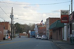
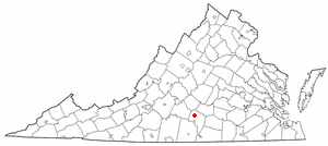
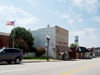
Charlotte Court House is a town in and the county seat of Charlotte County, Virginia, United States. The population was 756 at the 2020 census.

<span class="mw-page-title-main">Keysville, Virginia</span> Town in Virginia, United States

Keysville is a town in Charlotte County, Virginia, United States. The population was 832 at the 2010 census. One of two branches of Southside Virginia Community College is in Keysville. The surrounding area has tobacco and mixed farming.

<span class="mw-page-title-main">Phenix, Virginia</span> Town in Virginia, United States

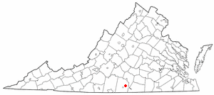
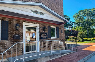
Phenix is a town in Charlotte County, Virginia, United States. The population was 226 at the 2010 census.

<span class="mw-page-title-main">Glen Lyn, Virginia</span> Town in Virginia, United States

Glen Lyn is a town in Giles County, Virginia, United States, at the confluence of the East and New rivers. The population was 115 at the 2010 census, down from 151 at the 2000 census. It is part of the Blacksburg–Christiansburg Metropolitan Statistical Area.

<span class="mw-page-title-main">Halifax, Virginia</span> Town in Virginia, United States

Halifax is a town in Halifax County, Virginia, United States, along the Banister River. The population was 1,309 at the 2010 census. It is the county seat of Halifax County.

<span class="mw-page-title-main">Scottsburg, Virginia</span> Town in Virginia, United States

Scottsburg is a town in Halifax County, Virginia, United States. The population was 119 at the 2010 census, down from 145 at the 2000 census.

<span class="mw-page-title-main">Virgilina, Virginia</span> Town in Virginia, United States

Virgilina is a town in Halifax County, Virginia, United States. The population was 154 at the 2010 census. Virgilina was once a copper mining town. It was a stop on the Atlantic and Danville Railway as recently as the 1950s. It is named "Virgilina" because it is located on the Virginia and North Carolina border.

<span class="mw-page-title-main">Ridgeway, Virginia</span> Town in Virginia, United States

Ridgeway is a town in Henry County, Virginia, United States. The population was 742 at the 2010 census. It is part of the Martinsville Micropolitan Statistical Area. Martinsville Speedway, a NASCAR racetrack, is located between Ridgeway and the Martinsville city limits.

<span class="mw-page-title-main">Kenbridge, Virginia</span> Town in Virginia, United States

Kenbridge is a town in Lunenburg County, Virginia, United States. The population was 1,257 at the 2010 census. It is in a tobacco farming area. The area is home to noted folk artist Eldridge Bagley. The town is home to the Lunenburg Girls’ Softball league, Lunenburg Lightning Football and Cheerleading league and the United Futbol Soccer league. There are many quaint shops and boutiques and many family owned businesses. Home to Kenbridge Elementary School. Visit www.kenbridgeva.net for information.

<span class="mw-page-title-main">La Crosse, Virginia</span> Town in Virginia, United States

La Crosse is a town in Mecklenburg County, Virginia, United States. Its name is derived from the fact that it was a place where railroads once crossed, and there is still a caboose in the center of the town. La Crosse is adjacent to the neighboring town South Hill.

<span class="mw-page-title-main">Broadway, Virginia</span> Town in Virginia, United States

Broadway is a town in Rockingham County, Virginia, United States. The population was 3,691 at the 2010 census. It is included in the Harrisonburg Metropolitan Statistical Area.

<span class="mw-page-title-main">Capon Bridge, West Virginia</span> Town in West Virginia, United States

Capon Bridge is a town in eastern Hampshire County, West Virginia, United States, along the Northwestern Turnpike, approximately 20 miles (32 km) west of Winchester, Virginia. The population was 418 at the 2020 census. Originally known as "Glencoe", Capon Bridge was incorporated in 1902 by the Hampshire County Circuit Court. It is named because of the construction of the bridge over the Cacapon River at that place, the name of the river being derived from the Shawnee Cape-cape-de-hon, meaning "river of medicine water".

<span class="mw-page-title-main">Carpendale, West Virginia</span> Town in West Virginia, United States

Carpendale is a town in Mineral County, West Virginia, United States, and part of the Cumberland, MD-WV Metropolitan Statistical Area'. The population was 861 at the 2020 census. Carpendale was incorporated on January 2, 1990, by the Circuit Court. The town is a combination of three subdivisions of which its name reflects: Carpenters Addition, Millerdale I, and Millerdale II. There are no stores in Carpendale and there is only one road in and out of the town.

<span class="mw-page-title-main">Grottoes, Virginia</span> Town in Virginia, United States

Grottoes is an incorporated town in Augusta and Rockingham counties in the U.S. state of Virginia. The population was 2,668 at the 2010 census.

<span class="mw-page-title-main">Brodnax, Virginia</span> Town in Virginia, United States

Brodnax is a town in Brunswick and Mecklenburg counties in the U.S. state of Virginia. The population was 298 at the 2010 census.

References

  1. "2019 U.S. Gazetteer Files". United States Census Bureau. Retrieved August 7, 2020.
  2. 1 2 "Population and Housing Unit Estimates". United States Census Bureau. May 24, 2020. Retrieved May 27, 2020.
  3. 1 2 "U.S. Census website". United States Census Bureau . Retrieved 2008-01-31.
  4. "US Board on Geographic Names". United States Geological Survey. 2007-10-25. Retrieved 2008-01-31.
  5. 1 2 "Geographic Identifiers: 2010 Demographic Profile Data (G001): Drakes Branch town, Virginia". U.S. Census Bureau, American Factfinder. Retrieved August 25, 2015.[ dead link ]
  6. "US Gazetteer files: 2010, 2000, and 1990". United States Census Bureau. 2011-02-12. Retrieved 2011-04-23.
  7. "Census of Population and Housing". Census.gov. Retrieved June 4, 2015.