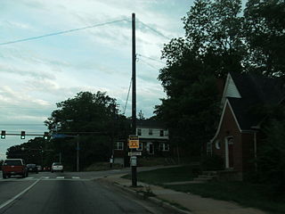
Groveton is a census-designated place (CDP) in Fairfax County, Virginia, United States. The population was 14,598 at the 2010 census, down from 21,296 in 2000 due to a reduction in area. Located south of the city of Alexandria, it encompasses numerous neighborhoods including Groveton, Bucknell Manor, Stoneybrooke, and portions of Hollin Hills. Huntley Meadows Park, Fairfax County's largest park, is located in the southwest part of the CDP.

Lincolnia is a census-designated place (CDP) in Fairfax County, Virginia, United States. The population was 22,828 at the 2010 census, an increase of over 44% from 2000.

Wolf Trap is a census-designated place (CDP) in Fairfax County, Virginia, United States. The population was 16,131 at the 2010 census. Wolf Trap National Park for the Performing Arts is located in the CDP.

Mechanicsville is an unincorporated community and census-designated place (CDP) in Hanover County, Virginia, United States. The population was 39,482 during the 2020 census, up from 36,348 in the 2010 census.
Short Pump is a census-designated place (CDP) in Henrico County, Virginia, United States. It is a suburb of Richmond, Virginia. The population was 30,626 at the 2020 census.

Marshall is a census-designated place (CDP) in northwestern Fauquier County, Virginia, in the United States. The population as of the 2010 census was 1,480.
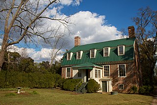
Belmont is a census-designated place (CDP) in Loudoun County, Virginia, United States. The population as of the 2010 United States Census was 5,966. It is 5 miles (8 km) southeast of Leesburg, the Loudoun county seat, and 31 miles (50 km) northwest of Washington, D.C. The Belmont Manor House, built between 1799 and 1802 by a son of Richard Henry Lee, is in the northeast part of the CDP and is now the clubhouse for a gated golf community.
Allenport is an unincorporated community and census-designated place (CDP) in Huntingdon County, Pennsylvania, United States. It lies southeast of Mount Union on the Juniata River in Shirley Township. The population was 648 as of the 2010 census.

Broadlands is a census-designated place (CDP) in Loudoun County, Virginia, United States. It is a 1,500-acre (610 ha) master-planned community started and developed by Van Metre Homes in the 1990s. It is built on wetlands and is certified as a Community Wildlife Habitat by the National Wildlife Federation.

Hanover is an unincorporated community and census-designated place (CDP) in Hanover County, Virginia, United States. It is the county seat and is located at the junction of U.S. Route 301 and State Route 54 south of the Pamunkey River. While historically known as Hanover Courthouse, the U.S. Geological Survey, Census Bureau, Postal Service and residents refer to it as "Hanover". The population as of the 2010 census was 252.

King William is a census-designated place (CDP) in and the county seat of King William County, Virginia, United States. The population as of the 2010 census was 252. Located in King William is the oldest courthouse in continuous use in the United States, built in 1725. The community is also known as King William Courthouse or, by an alternative spelling, King William Court House.

Bowmansville is an unincorporated community and census-designated place (CDP) in Brecknock Township, Lancaster County, Pennsylvania, United States. Bowmansville is home to the Pennsylvania Turnpike's Bowmansville Service Plaza. The population was 2,077 as of the 2010 census.
Central Garage is a census-designated place (CDP) in King William County, Virginia, United States. The population as of the 2010 census was 1,318.
Stollings is an unincorporated community and census-designated place (CDP) in central Logan County, West Virginia, United States. As of the 2010 census, it had a population of 316.
University Center is a census-designated place (CDP) in Loudoun County, Virginia, United States. The population as of the 2010 United States Census was 3,586. Mailing addresses in the community are for Ashburn.
Blue Ridge Shores is a census-designated place (CDP) in Louisa County, Virginia, United States. The population as of the 2010 census was 813. It was built beginning in 1960 as a resort community around Lake Louisa.

Fair Oaks is a census-designated place in Fairfax County, Virginia, United States. The population at the 2020 census was 34,052. It encompasses a large area west of the city of Fairfax, centered on Fair Oaks Mall. Suburban neighborhoods and office parks occupy most of Fair Oaks, largely developed since the 1980s.
Henry Fork is an unincorporated community and census-designated place (CDP) in Franklin County, Virginia, United States, just south of Rocky Mount. The population as of the 2010 census was 1,234.

Newington Forest is a census-designated place in Fairfax County, Virginia, United States. The population as of the 2010 census was 12,442. It is part of the Washington metropolitan area. It includes the Newington Forest subdivision and several nearby neighborhoods of southern Springfield and northern Lorton.

Pottery Addition is a census-designated place (CDP) in Jefferson County, Ohio, United States. Its population was 258 as of the 2020 census. The community is located along the Ohio River and is served by Ohio State Route 7.


