Coleman Falls, Virginia | |
|---|---|
Unincorporated community | |
 | |
 Coleman Falls, Virginia  Coleman Falls, Virginia | |
| Coordinates: 37°30′06″N79°18′13″W / 37.50167°N 79.30361°W | |
| Country | United States |
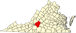
| State | Virginia |
| County | Bedford |
| Elevation | 682 ft (208 m) |
| Time zone | UTC-5 (Eastern (EST)) |
| • Summer (DST) | UTC-4 (EDT) |
| ZIP Code | |
| Area code | 434 |
| GNIS feature ID | 1492790 [1] |
Coleman Falls is an unincorporated community in northern Bedford County, Virginia, United States. The community is located along the James River and U.S. Route 501, between Big Island and Boonsboro. It is part of the Lynchburg Metropolitan Statistical Area.