Pre-colonial
The region encompassing modern KwaNojoli was inhabited by Khoisan hunter-gatherers for millennia before the arrival of Bantu-speaking peoples, including the Xhosa people, around the 15th century. The area's fertile valleys and proximity to the Great Fish River made it a vital corridor for migration and trade. Xhosa oral histories, documented in works such as J.H. Soga's "The South-Eastern Bantu" [9] (1930), describe the land as part of the broader AmaXhosa territory, with clans like the Ngqika utilizing the Boschberg slopes for grazing and spiritual practices. European explorers, including Swedish botanist Anders Sparrman in the late 1770s, noted the region's abundant wildlife, diverse flora, and established indigenous communities in their journals, highlighting a landscape teeming with antelope, birds, and endemic plants.
The Boschberg (today colloquially known as Bosberg) area, encountered by Dutch explorers as early as 1711 and named for its dense bush vegetation (Dutch: "Boschberg", meaning "bush or forested mountain"), served as a natural boundary and resource hub for local Xhosa groups. Conflicts over land use foreshadowed later colonial tensions, as Trekboers began encroaching from the west in the mid-18th century.
The Cape under British rule
The early 19th century brought intensified British influence following the Cape's second occupation in 1806. The 1811–1812 Zuurveld clearances, also known as the Fourth Frontier War or Fourth Xhosa War, marked a brutal escalation in the Cape Colony's expansionist policies against the Xhosa people. This conflict, the first major engagement under direct British rule after their 1806 occupation of the Cape, resulted in the forcible expulsion of approximately 20 000 Xhosa and allied Khoekhoe from the Zuurveld (Suurveld)—a fertile neutral buffer zone between the Sundays River and the Great Fish River, spanning modern-day Eastern Cape districts like Albany and Bathurst. By mid-1812, the Zuurveld was "cleared" and fortified with blockhouses and a military line along the Fish River, renamed the "Cape Eastern Frontier." This paved the way for the 1820 British Settler influx, who occupied the depopulated lands as a buffer against future Xhosa incursions.
Lord Charles Somerset, Governor of the Cape Colony from 1824 to 1826, envisioned frontier settlements to secure the border against Xhosa incursions and support military logistics. In 1815, Somerset established an experimental farm at Boschberg, selected by American botanist Dr. Joseph Mackrill from sites including the Gamtoos and Swartkops Valleys, to breed superior livestock, cultivate export crops like tobacco, and supply troops with grain and fodder. Subsidized infrastructure, including soldiers' barracks and a water mill, was constructed, transforming the site into a semi-military outpost.
The farm was established in 1815, for the purpose of improving stockbreeding in the Cape Colony and providing produce for the soldiers at the Frontier. It was named "Somerset Farm". Under manager Robert Hart from 1817, the farm prospered as a refreshment station, procuring local produce for distribution. However, the project faltered due to administrative shifts. In January 1825, the Sub-Drostdy of Cradock was dissolved, and a new Drostdy (magistrate's district) named Somerset was proclaimed, stretching from the Orange River north to the Zuurberg south, and from the Sundays River west to the Koonap east. William Mackay was appointed the first magistrate on 31 January 1825, formalizing the town's layout along the Little Fish River. The "East" suffix was added around 1855 to distinguish it from Somerset West in the Western Cape.
This era was marred by the Slachter's Nek Rebellion of 1815–1816, a pivotal frontier uprising. Led by Hendrik Prinsloo (a relative of Willem), dispossessed Boers protested land seizures and stock thefts amid Xhosa-British skirmishes. Five rebels were executed by hanging from a beam (now displayed in the local museum) after a botched gallows collapse—symbolizing colonial overreach and fueling Afrikaner grievances. The event, occurring in the district, strained relations between settlers, authorities, and indigenous groups.
The mid-19th century saw Somerset East emerge as a bustling frontier hub, fueled by the wool boom and the arrival of the 1820 Settlers. Positioned on routes to the interior, it became a vital stopover for wagons bound for Graaff-Reinet and beyond. Industries flourished: wool trading dominated, supplemented by tanning, wagon-making, brickworks, and milling. Farms like Glen Avon, established by Robert Hart (dubbed the "Father of the 1820 Settlers"), introduced advanced irrigation and hosted one of South Africa's highest private waterfalls.
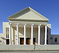
The town expanded with civic institutions. The Dutch Reformed Church congregation, the Eastern Cape's fourth oldest, was formalized in the 1830s, while the Old Wesleyan Chapel (1821), Anglican Church (1836) and British Officers' Mess (now the Walter Battiss Art Museum) reflected dual Anglo-Dutch influences. The first government school in the town was opened in 1842, and many of the early teachers and trustees were 1820 descendants. A municipality was established in 1884, overseeing growth amid the Anglo-Boer tensions.
The Frontier Wars (1779–1879), particularly the Sixth (1834–1836) and Eighth (1850–1853), directly impacted the district. Xhosa resistance to land dispossession led to raids and reprisals, with Somerset East serving as a British supply depot. Post-war, the area stabilized, but at the cost of Xhosa displacement, exacerbating racial divides.
The early 20th century brought infrastructural advances. The railway reached Somerset East in 1877, linking it to Port Elizabeth and enhancing wool exports. The town served as a conservative electoral constituency in the Union of South Africa (1910–1981), consistently returning Afrikaans-speaking National Party members, reflecting its rural, white-dominated polity.
Culturally, the town nurtured talents like artist Walter Battiss (1906–1982), born locally, whose modernist works drew on Xhosa motifs and rock art. Institutions like the Somerset East Museum (housed in the old parsonage) preserved frontier artifacts, including Slagtersnek relics, fostering a narrative centered on white settler heritage.
Renaming Somerset East to KwaNojoli
In March 2023, the town was officially renamed KwaNojoli, honoring Xhosa etymology and the area's pre-colonial significance, particularly the legacy of Nojoli. Oral histories as documented in the Jakes Gerwel Foundation's 2024 publication [11] , depict Nojoli as a real 18th-century Thembu princess (daughter of Nkosi Ndungwana), who married Xhosa chief Rharhabe and became his inkosikazi enkulu (great wife). The publication asserts she lived at Rharhabe's Great Kraal (iDlelo) "under the foot of Boschberg," with the mountain itself named Intaba kaNojoli ("Nojoli's Mountain") after her. This ties the area's "spiritual and communal ties" to her legacy.
The change, approved by the South African Geographical Names Council, sparked debate: proponents viewed it as restorative justice, while critics decried erasure of colonial history. Community dialogues, facilitated by groups like the Jakes Gerwel Foundation, highlighted racial tensions but fostered cohesion. Abel Boyce Piki's advocacy was instrumental, with his efforts culminating in the name's revival just before his passing in 2024.
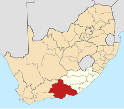
KwaNojoli challenges
In the post-apartheid era, KwaNojoli within the Blue Crane Route Local Municipality has grappled with chronic service delivery failures, including prolonged water outages and electricity disruptions that have sparked resident protests. In January 2022, locals burned tires outside the municipal offices after enduring 38 days without piped water since December 2021, highlighting infrastructural neglect and inadequate maintenance. By October 2025, households faced over three weeks of dry taps, dependent on sporadic water truck deliveries amid reports of sabotaged infrastructure and mismanagement. These issues reflect broader causal shortcomings in local governance, such as poor financial oversight and failure to sustain basic utilities, exacerbating resource strains from informal population growth without corresponding capacity expansion.
Local economic interventions via the Blue Crane Development Agency (BCDA) have aimed to counter peripheral decline through project facilitation, including tourism promotion and small-scale infrastructure upgrades, though outcomes remain limited by high national failure rates - 70% to 90% of land reform projects collapse due to insufficient post-transfer support, skills gaps, and elite capture rather than market dynamics alone. Assets like the Somerset East Aerodrome [12] , completed in 2016 for R53 million, exemplify implementation shortfalls, was reduced to a hazardous grazing area after fencing theft [13] went unaddressed.
Today, KwaNojoli's population of around 20,000 blends agricultural roots with eco-tourism. Challenges include rural depopulation and inequality, but its preserved architecture, oak-lined streets, Victorian homes and cultural sites position it as a gateway to Eastern Cape heritage.