Sookholme

Last updated

Sookholme
Sookholme Church - geograph.org.uk - 12652.jpg
St Augustine's Church, Sookholme
Nottinghamshire UK location map.svg
Red pog.svg
Sookholme
Location within Nottinghamshire
OS grid reference SK 54832 66931
Civil parish
District
Shire county
Region
Country England
Sovereign state United Kingdom
Post town MANSFIELD
Postcode district NG19
Dialling code 01623
Police Nottinghamshire
Fire Nottinghamshire
Ambulance East Midlands
UK Parliament
List of places
UK
England
Nottinghamshire
53°11′46″N1°10′48″W / 53.196°N 1.180°W / 53.196; -1.180
Sookholme
Map

Sookholme is a village and former civil parish, now in the parish of Warsop in the Mansfield district of western Nottinghamshire, England. It is 120 miles (190 km) north west of London, 16+34 miles (27.0 km) north of the county town and city of Nottingham, and 3+12 miles (5.6 km) north of the town of Mansfield. It retains an agricultural character, having been largely unaffected by the Industrial Revolution, which had a transformative impact on the settlement pattern and built form of numerous other settlements situated within the North Midlands coalfields. Whilst relatively close to the built up areas of Mansfield and Shirebrook, Sookholme is remote and rural. In 1931 the parish had a population of 210. [1]

Contents

Toponymy

Sookholme was not recorded in the Domesday Book of 1086. It first appeared in 1189 public records as Sulcholm, and centuries later, Sokeholme.

It lies in the Meden river valley, the Old English translation for this early spelling form is 'marshy land in the valley,'

An alternative interpretation is the use of the Anglo-Saxon words soc or soke, a privilege or jurisdiction, and holme, an island, or the rich land by a stream. So that Sokeholme originally meant the rich land by a stream. [2]

Geography

Sookholme is surrounded by the following local Nottinghamshire areas:

This area lies in the north west of the district and west of Nottinghamshire county, as well as being directly adjacent to the Derbyshire boundary. The core of the hamlet is accessed from the B6407 Mansfield-Shirebrook road. Surrounding the settlement is predominantly a farming area, interspersed by farms, occasional residential dwellings and some forested areas to the west, separating Sookholme from Shirebrook. Sookholme stands on the north bank of the River Meden, while there is a spring south west of the area which feeds a basin called Sookholme Bath, and which then drains through the heart of the village via Sookholme Brook into the Meden.

The wider area is low-lying, at a land elevation of 65–85 metres (213–279 ft), with higher peaks in Shirebrook and Spring Woods west of the village of 105–110 metres (344–361 ft).

Governance

The area is within Warsop parish, and is governed along with other local settlements at the first tier of public administration by Warsop Parish Council.

Mansfield District Council manage the middle level of public duties in the settlements.

Nottinghamshire County Council provides the highest strategic services locally.

Sookholme was formerly a township in Warsop parish, [3] from 1866 Sookholme was a civil parish in its own right until it was abolished on 1 April 1935 and merged with Warsop. [4]

History

Roman period

Numerous examples of Roman tile fragments have been found on several occasions in the field to the south of the pond known locally as the Sookholme Bath. These were first found in the 1930s and excavations throughout later decades were done but no kiln structures were found. Due to the overgrown surrounding areas of the pond and the waters, little follow up was done. The archives of Major Hayman Rooke contains sketches which displays Roman baths observed beneath the existing pond which possibly is what the tiles were used to create, and take advantage of the reputed healing waters of the nearby spring. The excavation report, drawings and tile samples are held in the Mansfield Museum's archaeology repository. [5]

Priory

Before the Reformation the manor belonged to the Priory of St. Oswald, at Nostell, in Yorkshire, and was likely served by a branch establishment of the priory in Sookholme. While no record of that remains, there is a field near Longster Lane leading to Shirebrook containing a number of yew trees planted in the form of a square—the kind that would be planted near an Anglican place of religion in the past. [6] In the reign of Edward III during the 14th century, the prior of St. Oswald claimed all sorts of privileges in the manor of Sookholme, but it could not be proven that he or his predecessors ever had those specific rights. [2]

Sookholme Hall

Also referred to as Sokeholme Hall, this was previously on the site of Eyre's farm-house, also known as present-day Hall Farm. At the beginning of the 19th century, part of the old hall still existed, and one of the upper rooms went by the name of " Lukin's Garret," and was said to be haunted by the ghost of a certain member of the Lukin family, who, according to tradition, committed suicide there. A brass tablet to the memory of Henry Lukin, of Sookholme Hall, is held in Warsop church, which states he was born at Great Baddow, Essex, in 1586, and died at Sookholme in 1630. The Foster family preceded Lukin at the Hall [7] and so infers the building was in place over some hundreds of years until around the year 1745, when Hall Farm was constructed at the location. [8]

Nettleworth Manor

Located to the south of Sookholme, Nettleworth Hall was the centrepiece of the manor and was built in 1566 by William Wylde. The hall was rebuilt following a fire in 1785. [9] It was sold by the Wylde family to Sir Henry Gally Knight, and it later passed to Sir Henry Fitzherbert, of the FitzHerbert baronets. [10] When Rev. Richard Fitzherbert inherited the baroncy in 1896 he resigned as rector of Warsop and moved from the rectory to Nettleworth Manor. The nearby Nettleworth farm was also part of the holdings. The hall by 1939-40 was in the ownership of the Neville family, who then dismantled it to prevent the military taking possession of it for war purposes. The service wing was left standing on site which has since been converted into residential quarters. [11]

Post Reformation

After the English Reformation, Sookholme was granted to the Leek family, and from them it descended to the Cavendishes, one of whom was the Duke of Newcastle. The manor later passed to the Dukes of Portland, and, through them, by an exchange of land, to Henry Gally Knight, and on to the FitzHerbert family as part of their wider Warsop holdings. [12] In the 1700s there was a public house and a mill recorded in the area. [7] Sookholme was a civil parish from 1866 until 1935, when it was merged into Warsop parish. [13] The barn and adjoining farm buildings at Hall Farm were converted into a number of homes in the early 2010s. [14]

Landmarks

Sookholme Lane over Hammerwater Bridge by the River Meden Hammerwater Bridge, Warsop - geograph.org.uk - 12646.jpg
Sookholme Lane over Hammerwater Bridge by the River Meden

Sookholme Bath

Sookholme Bath is the site of a natural spring forming the source of Sookholme Brook. There is evidence that the spring was used as an ancient healing spa, as nearby fragments of Roman bricks and tiles have been found, suggesting it was the site of a possible Roman tile kiln. [15]

Sookholme Brook SSSI

A former limestone quarry stretches the whole length of Sookholme Brook and is a Site of Special Scientific Interest together with the Hills and Holes area where the brook joins the River Meden. It also encompasses Sookholme Moor at its northern extremity. This area contains notable wildlife and holds some of the finest remaining limestone flora in Nottinghamshire. [16]

Shirebrook Wood

This is alternatively known as Three Lakes Country Park, and is managed by Forestry England. Despite the name, the wood has a sizable portion within Nottinghamshire, adjacent to Sookholme and visitors access is primarily by means of Longster Lane. The woods contain a mixture of mature broadleaf woodland, newly planted trees, large open meadows and a scenic wetland valley. It also provides home to a variety of wildlife including songbirds, small mammals and butterflies. The Millennium hedge was planted to celebrate the millennium and runs along the border between Nottinghamshire and Derbyshire. [17] Spring Wood, a subsection of the wider park, is to the south of Bath Lane, but is wholly within Derbyshire.

Listed buildings

Five buildings of local architectural interest are registered as listed, mainly aligned along the historic portion of the village by Sookholme Lane.

The buildings are mainly Grade II, including:

Religious sites

St Augustine's Church

The small chapel, consisting of nave and chancel, was built in the reign of Henry II in the 12th century. Its plan is almost two squares, with the larger square for the nave and the smaller the chancel, with door at the west end. This front was taken down and rebuilt further east, removing about a third of its old length from the nave. If this third had remained, Sookholme would be one of those small chapels with square-ended sanctuaries, commonly built in Saxon and Norman times. There is no tower or spire. [2]

Sport

The John Fretwell Sporting Complex lies along the B6407 road between Sookholme and Mansfield. Primarily for cricket, other facilities include football and bowls.

Transport

The Robin Hood Line passes between Sookholme and Shirebrook. The High Marnham test track run by Network Rail passes to the north of the village. It reuses the former LNER railway line that ran between Chesterfield, Shirebrook and onwards to Lincoln. The nearest public accessible stop is to the west of Sookholme at Shirebrook railway station.

Related Research Articles

<span class="mw-page-title-main">Pleasley</span> Human settlement in England

Pleasley is a village and civil parish with parts in both Derbyshire and Nottinghamshire. It lies between Chesterfield and Mansfield, 5 miles (8 km) south east of Bolsover, Derbyshire, England and 2.5 miles (4 km) north west of Mansfield, Nottinghamshire. The River Meden, which forms the county boundary in this area, runs through the village.

<span class="mw-page-title-main">River Meden</span> River in Nottinghamshire, England

The River Meden is a river in Nottinghamshire, England. Its source lies just north of Huthwaite, near the Derbyshire border, and from there it flows north east through Pleasley and Warsop before merging temporarily with the River Maun near Bothamsall. The rivers divide after a short distance and go on separately to a point near Markham Moor where they once more combine to form the River Idle.

<span class="mw-page-title-main">Shirebrook</span> Human settlement in England

Shirebrook is a town in the Bolsover district in Derbyshire, England. Close to the boundaries with the districts of Mansfield and Bassetlaw of Nottinghamshire, it had a population of 13,300 in 2001, reducing to 9,760 at the 2011 Census. It is on the B6407, and close to the A632 road, between Mansfield and Bolsover.

<span class="mw-page-title-main">Mansfield (UK Parliament constituency)</span> Parliamentary constituency in the United Kingdom, 1885 onwards

Mansfield is a constituency created in 1885 represented in the House of Commons of the UK Parliament since 2017 by Ben Bradley of the Conservative Party, who gained the seat at the 2017 general election, from the Labour Party. This is the first time the seat has been represented by a Conservative since its creation in 1885.

<span class="mw-page-title-main">Shirebrook railway station</span> Railway station in Derbyshire, England

Shirebrook railway station serves the town of Shirebrook in Derbyshire, England. The station is on the Robin Hood Line, 21½ miles (35 km) north of Nottingham towards Worksop.

<span class="mw-page-title-main">A617 road</span> Road in England

The A617 road runs through the northern East Midlands, England, between Newark-on-Trent and Chesterfield.

<span class="mw-page-title-main">Skegby</span> Human settlement in England

Skegby is a village and former civil parish in the Ashfield district of Nottinghamshire, England. It is located two miles west of Mansfield and one mile north of Sutton-in-Ashfield, close to Stanton Hill and lies on the B6014 road. Skegby sits on both sides of a deep valley near the source of the River Meden.

<span class="mw-page-title-main">Langwith, Derbyshire</span> Collection of villages in Derbyshire, England

Langwith is a close group of six villages crossing the Derbyshire-Nottinghamshire border, on the River Poulter about 2 miles (3.2 km) from Warsop, and about 4 miles (6.4 km) from Bolsover on the A632 road, south of Whaley Thorns. The population is listed under the Nottinghamshire civil parish of Nether Langwith.

<span class="mw-page-title-main">Warsop railway station</span> Former railway station in Nottinghamshire, England

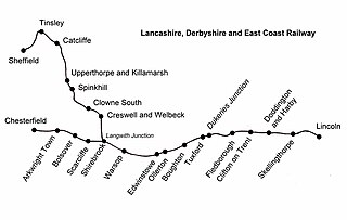
Warsop railway station is a former railway station in Market Warsop, Nottinghamshire, England.

<span class="mw-page-title-main">Warsop</span> Human settlement in England

Warsop is a town and civil parish in Mansfield District, Nottinghamshire, England, on the outskirts of the remnants of Sherwood Forest. At the 2001 census it had a population of 12,365, reducing to 11,999 at the 2011 Census including Church Warsop, Meden Vale, Sookholme and Spion Kop.

Perlethorpe cum Budby is a civil parish in the Newark and Sherwood district, within the county of Nottinghamshire, England. The overall area had a population of 183 at the 2011 census. The parish lies in the north west of the county and district. It is 125 mi (201 km) north of London, 8 mi (13 km) north east of Mansfield and 20 mi (32 km) north of the city of Nottingham. The parish and wider area is at the heart of Sherwood Forest, which is associated with the Robin Hood legend. Thoresby Hall, which is a notable ducal country house and estate is also within the boundaries of the parish.

<span class="mw-page-title-main">Marnham, Nottinghamshire</span> Civil parish in Nottinghamshire, England

Marnham is a civil parish in the Bassetlaw district, in the county of Nottinghamshire, England. The parish includes the village of Low Marnham and the hamlets of High Marnham and Skegby. In 2011 the parish had a population of 117. The parish lies in the north east of the county, and south east within the district. It is 122 miles north of London, 23 miles north east of the city of Nottingham, and 17 miles north east of the market town of Mansfield. The parish touches Fledborough, Normanton on Trent, South Clifton, Tuxford and Weston. Marnham shares a parish council with Normanton on Trent. There are 7 listed buildings in Marnham.

<span class="mw-page-title-main">Norton and Cuckney</span> Civil parish in Bassetlaw, England

Norton and Cuckney is a former civil parish, now in the parish of Norton, Cuckney, Holbeck and Welbeck, in the Bassetlaw district, within the county of Nottinghamshire, England. The overall area had a population of 351 at the 2011 census. The parish lay in the north west of the county, and south west within the district. The parish lies close to the county border with Derbyshire. It is 125 miles north west of London, 20 miles north of the city of Nottingham, and 5 miles north of the market town of Mansfield. The area was bordering Sherwood Forest and has associations with mining interests and the Welbeck Estate.

<span class="mw-page-title-main">Skegby, Bassetlaw</span> Settlement in Nottinghamshire, England

Skegby is a hamlet within the Marnham civil parish in Bassetlaw district, of the county of Nottinghamshire, England. It lies in the north east of the county, south east within the district and centre south of the parish. It is 122 miles (196 km) north of London, 23 mi (37 km) north east of the city of Nottingham, and 17 mi (27 km) north east of the market town of Mansfield. There are two listed buildings in the area.

<span class="mw-page-title-main">Scofton</span> Hamlet in Nottinghamshire, England

Scofton is a hamlet in the Bassetlaw district of northern Nottinghamshire, England. It is 130 miles (210 km) north west of London, 25 miles (40 km) north of the county town and city of Nottingham, and 3 miles (4.8 km) east of the nearest town Worksop. Having a shared modern history with nearby Osberton Hall, it is sometimes referred to as Scofton-with-Osberton. Other close neighbours are Bilby and Rayton which also have historical associations.

<span class="mw-page-title-main">Warsop Vale</span> Village in Nottinghamshire, England

Warsop Vale is a village in the Mansfield district of western Nottinghamshire, England. It is 18 miles (29 km) north of Nottingham, and 5 miles (8.0 km) north of Mansfield. It is in the civil parish of Warsop. Warsop Vale's heritage is primarily as a former mining village. It lies in the very picturesque area known as the Dukeries and is easily accessible to Clumber Park, Thoresby Park and hall, Rufford Park and the Earl of Portland estate of Welbeck, together all part of Sherwood Forest.

<span class="mw-page-title-main">Offcote and Underwood</span> Civil parish in Derbyshire, England

Offcote and Underwood is a civil parish within the Derbyshire Dales district, in the county of Derbyshire, England. Largely rural, in 2011 the parish had a population of 526. It is 125 miles (201 km) north west of London, 13 miles (21 km) north west of the county city of Derby, and 1 mile north east of the market town of Ashbourne. Offcote and Underwood borders the Peak District, and touches the parishes of Ashbourne, Bradley, Clifton and Compton, Fenny Bentley, Kniveton, Mapleton and Okeover. There are 12 listed buildings in Offcote and Underwood.

<span class="mw-page-title-main">Eaton and Alsop</span> Civil parish in Derbyshire Dales, England

Eaton and Alsop is a civil parish within the Derbyshire Dales district, in the county of Derbyshire, England. Largely rural, Along with the adjacent Newton Grange parish, in 2011 Eaton and Alsop had a population of 155. It is 130 miles (210 km) north west of London, 17 miles (27 km) north west of the county city of Derby, and 6 miles (9.7 km) north of the market town of Ashbourne. Eaton and Alsop is wholly within the Peak District national park, and touches the parishes of Alstonefield, Hartington Nether Quarter, Newton Grange and Parwich. There are five listed buildings in Eaton and Alsop.

<span class="mw-page-title-main">Holymoorside and Walton</span> Civil parish in Derbyshire, England

Holymoorside and Walton is a civil parish within the North East Derbyshire district, which is in the county of Derbyshire, England. Named for its main settlements, with a mix of a number of villages and hamlets amongst a large rural area, it had a population of 2,223 residents in 2011. The parish is 130 miles (210 km) north west of London, 20 miles (32 km) north of the county city of Derby, and 2 miles (3.2 km) south west of the nearest market town of Chesterfield. It is adjacent with the Peak District national park to the west, and shares a border with the district of Chesterfield, along with the parishes of Ashover, Beeley, Brampton as well as Wingerworth. The parish paradoxically does not include the majority of the nearby built-up suburb of Walton, Chesterfield which is now within an adjacent unparished area of the borough.

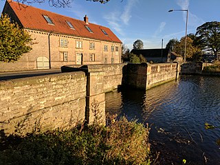
Warsop is a civil parish in the Mansfield District of Nottinghamshire, England. The parish contains 28 listed buildings that are recorded in the National Heritage List for England. Of these, two are listed at Grade I, the highest of the three grades, one is at Grade II*, the middle grade, and the others are at Grade II, the lowest grade. The parish contains the town of Warsop, the settlements of Church Warsop and Sookholme, and the surrounding countryside. Most of the listed buildings are houses, cottages and associated structures, farmhouses and farm buildings. The other listed buildings include two churches with associated structures, a parish centre converted from an old courtyard house, a public house, a bridge and a weir, a watermill, a windmill, and a war memorial.

References

  1. "Population statistics Sookholme Tn/CP through time". A Vision of Britain through Time . Retrieved 16 January 2022.
  2. 1 2 3 "Nottinghamshire history > H Walkerdine and A S Buxton, Old churches of the Mansfield Deanery (1907)". www.nottshistory.org.uk. Retrieved 20 February 2021.
  3. "History of Sookholme, in Mansfield and Nottinghamshire". A Vision of Britain through Time. Retrieved 16 January 2022.
  4. "Relationships and changes Sookholme Tn/CP through time". A Vision of Britain through Time. Retrieved 16 January 2022.
  5. "Sookholm Kiln 1995 - Sherwood Archaeology Society". www.sherwood-archaeology.co.uk. Retrieved 20 February 2021.
  6. "Warsop Parish Church | St Augustine, Sookholme" . Retrieved 20 February 2021.
  7. 1 2 Richard J. King (1884). Warsop Parish Registers, with Notes and Illustrations. Oxford University. Printed by William Gouk.
  8. 1 2 Stuff, Good. "Hall Farmhouse, Warsop, Nottinghamshire". britishlistedbuildings.co.uk. Retrieved 20 February 2021.
  9. "Nettleworth | British History Online". www.british-history.ac.uk. Retrieved 21 February 2021.
  10. GENUKI. "Genuki: White's Directory of Nottinghamshire, 1853, Nottinghamshire". www.genuki.org.uk. Retrieved 21 February 2021.
  11. "Mansfield district - heritage assets report".
  12. GENUKI. "Genuki: Warsop, Nottinghamshire". www.genuki.org.uk. Retrieved 20 February 2021.
  13. "GB Historical GIS / University of Portsmouth, Sookholme Tn/CP through time | Census tables with data for the Parish-level Unit, A Vision of Britain through Time".
  14. "Hall Farm Barns, Sookholme". Swallow Hill Homes. 14 January 2021. Retrieved 20 February 2021.
  15. "Mansfield District Council, tourism guide to Local Nature Reserves & Parks in Mansfield District" (PDF).
  16. "Hills & Holes & Sookholme Brook, Warsop". Walk & Fork. Retrieved 21 February 2021.
  17. "Shirebrook Wood". Forestry England. Retrieved 21 February 2021.
  18. Stuff, Good. "Barn and Adjoining Farm Buildings at Hall Farm, Warsop, Nottinghamshire". britishlistedbuildings.co.uk. Retrieved 20 February 2021.
  19. Stuff, Good. "Mill Farmhouse and Adjoining Farm Buildings and Boundary Wall, Warsop, Nottinghamshire". britishlistedbuildings.co.uk. Retrieved 20 February 2021.