
Tamaulipas, officially the Free and Sovereign State of Tamaulipas, is a state in Mexico; one of the 31 states which, along with Mexico City, comprise the 32 Federal Entities of Mexico. It is divided into 43 municipalities.

Ciudad Victoria is the seat of the Municipality of Victoria, and the capital of the Mexican state of Tamaulipas. It is located in the northeast of Mexico at the foot of the Sierra Madre Oriental. It borders the municipality of Güémez to the north, Llera to the south, Casas Municipality to the east, and the municipality of Jaumave to the west. The city is located 246 km (153 mi) from Monterrey and 319 km (198 mi) from the US - Mexico border. Ciudad Victoria is named after the first president of Mexico, Guadalupe Victoria.
Laguna Madre is a coastal lagoon in Northeastern Mexico. It extends along the coast of Tamaulipas for over 200 km, from the Río Bravo Delta on the north to the mouth of the Soto la Marina River near La Pesca in the south. Laguna Madre is separated from the Gulf of Mexico on the east by a number of barrier islands, including Barra Los Americanos, Barra Jesús María, and Barra Soto la Marina, and is bounded on the west by the Tamaulipan mainland. It is located in the municipalities of Matamoros, San Fernando, and Soto la Marina.

Aldama is a municipality of the northeastern Mexican state of Tamaulipas. According to the census of 2010, the municipality had an area of 3,672 square kilometres (1,418 sq mi) and a population of 29,470, including the town of Aldama with a population of 13,661.

The Municipality of Pachuca de Soto, or Municipality of Pachuca, is one of the Municipalities of the state of Hidalgo, located in east-central Mexico.

The Tamaulipan mezquital, also known as the Brush Country, is a deserts and xeric shrublands ecoregion in the Southern United States and northeastern Mexico. It covers an area of 141,500 km2 (54,600 sq mi), encompassing a portion of the Gulf Coastal Plain in southern Texas, northern Tamaulipas, northeastern Coahuila, and part of Nuevo León.
La Pesca is a small town in the Mexican state of Tamaulipas. It is located on the Gulf of Mexico, at the mouth of the Río Soto La Marina, between the Laguna Madre to the north and the Laguna Morales to the south. It stands due east of state capital Ciudad Victoria, in the municipality of Soto la Marina.
Casas is a municipality located in the Mexican state of Tamaulipas.
Jiménez Municipality is a municipality located in the Mexican state of Tamaulipas. Its municipal capital is the town of Santander Jiménez.

Mainero is a municipality located in the Mexican state of Tamaulipas. Its capital is called Villa Mainero and had 338 inhabitants during a 2020 INEGI census. The municipality as a whole had 2 048 inhabitants. Other localities include José Guadalupe Mainero, Guadalupe Mainero and Guadalupe Mainero. All named after Guadalupe Mainero (1856–1901), a Mexican journalist, teacher and governor of Tamaulipas between May 4, 1896 and July 31, 1901.

Padilla Municipality is a municipality in the Mexican state of Tamaulipas. After the flood at the Vicente Guerrero Dam in 1970, the seat was moved from Padilla to the town of Nuevo Padilla.

Soto la Marina is a town in Soto la Marina Municipality located in the Mexican state of Tamaulipas. It was directly hit by Hurricane Alex in 2010. It is located on the banks of the Soto la Marina river, just up river from the small ocean port of La Pesca, and downriver from Ciudad Victoria, the capital of the State of Tamaulipas. 180 miles South of Brownsville, Texas, it is accessible from there via a highway in approximately 3 hours driving time.

The Soto La Marina River or Soto la Marina is a river of northeastern Mexico.

Río Bravo Municipality is one of the municipalities in the Mexican state of Tamaulipas. The seat is at Río Bravo, Tamaulipas.

General Zaragoza is a municipality and town of the northeastern Mexican state of Nuevo León. It is located in the south-eastern part of the state. The town is at 23°58′25″N99°46′23″W. The municipality has a total area of 508 square miles (1,315 km2) and had a population of 5,942 in 2010. Most of the population lives in the town of Zaragoza. The elevation of Zaragoza is 4,520 feet (1,379 m). Zaragoza is bordered by Aramberri, on the south and east by Hidalgo, Tamaulipas, and on the west by Doctor Arroyo.
Federal Highway 107 is a Federal Highway of Mexico. The highway travels from Mexican Federal Highway 101 at Jiménez, Tamaulipas in the north to Mexican Federal Highway 180 north of Soto la Marina, Tamaulipas in the south. Federal Highway 107 is co-signed with Tamaulipas Highway 38.

Nuevo Padilla, Tamaulipas is a Mexican town in the state of Tamaulipas and the seat of the municipality of Padilla. It was established in 1970 after the flood of the town of Padilla, Tamaulipas, the place where the historical figures of Agustín de Iturbide and Manuel de Mier y Terán died.
The Sierra de Tamaulipas is an isolated, semi-tropical mountain range in the Mexican state of Tamaulipas. Its highest point is 1,260 m (4,130 ft). There are no cities or towns in the Sierra and the small population is largely agricultural. The higher elevations of the Sierra have forests of oak and pine, contrasting with the semi-arid brush that dominates at lower altitudes. Several archaeological sites establish that the Sierra de Tamaulipas was the northern outpost of the agricultural Mesoamerican peoples of eastern Mexico.
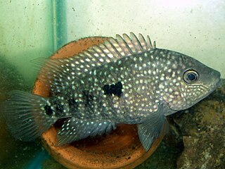
Herichthys teporatus, also known as the Soto la Marina cichlid, is a species of cichlid fish endemic to Mexico where it occurs in the Soto La Marina River drainage in the state of Tamaulipas.
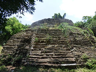
El Sabinito is a Pre-Columbian ruin associated with the Huastec civilization. Located in the Mexican state of Tamaulipas, El Sabinito is approximately 25 kilometers southwest and 96 kilometers east of the modern-day cities Soto la Marina and Ciudad Victoria. Alongside the Balcon de Montezuma, El Sabinito marks the northernmost boundary of Mesoamerican civilization.

