South Dayton, New York

Last updated

South Dayton, New York
South Dayton Station - June 2015.jpg
The former Buffalo and South Western Railroad station in South Dayton.
USA New York location map.svg
Red pog.svg
South Dayton
Location within the state of New York
Coordinates: 42°21′46″N79°3′6″W / 42.36278°N 79.05167°W / 42.36278; -79.05167
CountryUnited States
State New York
County Cattaraugus
Town Dayton
Area
[1]
  Total1.01 sq mi (2.60 km2)
  Land1.01 sq mi (2.60 km2)
  Water0.00 sq mi (0.00 km2)
Elevation
1,306 ft (398 m)
Population
 (2020)
  Total541
  Density537.77/sq mi (207.69/km2)
Time zone UTC-5 (Eastern (EST))
  Summer (DST) UTC-4 (EDT)
ZIP code
14138
Area code 716
FIPS code 36-68891
GNIS feature ID0965735
Website www.southdaytonny.org

South Dayton is a village in Cattaraugus County, New York, United States. The population was 564 at the 2020 census. [2] The village lies within the town of Dayton by the southwest corner of the town and less than a mile from the border of Chautauqua County.

Contents

History

The community was also known as "Pine Valley"; the name Pine Valley was later used for the name of the local school district (shared with neighboring Cherry Creek), the campus of which is situated southwest of the village. The arrival of the railroad in 1875 promoted the growth of the village, which incorporated in 1915.

Possibly the most famous event to occur in South Dayton is that a revelation is reported to have been received by the Mormon prophet, Joseph Smith, in the home of Freeman Nickerson on October 12, 1833, known as Section 100 of the Doctrine and Covenants. At the time the settlement was within the town of Perrysburg. [3] [4]

South Dayton was used as a filming location for the 1987 comedy road film, Planes, Trains and Automobiles . It was also featured in the classic film, The Natural , which starred Robert Redford.

Geography

South Dayton is located at 42°21′46″N79°3′6″W / 42.36278°N 79.05167°W / 42.36278; -79.05167 (42.362796, -79.051715). [5] The western boundary of the village follows the Chautauqua County line.

According to the United States Census Bureau, the village has a total area of 1.0 square mile (2.6 km2), all land. [6]

County Road 2 (Main Street in the village) and NY-322 pass through the village. The New York and Lake Erie Railroad serves the village with freight and occasional passenger rail service.

Skunks Corners is a crossroads in the southwestern part of the village.

Demographics

Historical population
CensusPop.Note
1880 318
1920 655
1930 570−13.0%
1940 64312.8%
1950 72713.1%
1960 696−4.3%
1970 688−1.1%
1980 661−3.9%
1990 601−9.1%
2000 66210.1%
2010 620−6.3%
2020 564−9.0%
2021 (est.)558 [2] −1.1%
U.S. Decennial Census [7]

As of the census [8] of 2000, there were 662 people, 248 households, and 163 families residing in the village. The population density was 658.2 inhabitants per square mile (254.1/km2). There were 268 housing units at an average density of 266.5 per square mile (102.9/km2). The racial makeup of the village was 97.73% White, 0.30% African American, 0.30% Native American, 0.45% from other races, and 1.21% from two or more races. Hispanic or Latino of any race were 1.51% of the population.

There were 248 households, out of which 35.5% had children under the age of 18 living with them, 44.0% were married couples living together, 16.1% had a female householder with no husband present, and 33.9% were non-families. 25.8% of all households were made up of individuals, and 10.9% had someone living alone who was 65 years of age or older. The average household size was 2.67 and the average family size was 3.20.

In the village, the population was spread out, with 33.7% under the age of 18, 7.1% from 18 to 24, 26.6% from 25 to 44, 21.0% from 45 to 64, and 11.6% who were 65 years of age or older. The median age was 33 years. For every 100 females, there were 87.0 males. For every 100 females age 18 and over, there were 88.4 males.

The median income for a household in the village was $29,375, and the median income for a family was $32,917. Males had a median income of $25,833 versus $22,404 for females. The per capita income for the village was $13,187. About 15.4% of families and 17.3% of the population were below the poverty line, including 20.0% of those under age 18 and 6.2% of those age 65 or over.

Notable people

Related Research Articles

<span class="mw-page-title-main">Montgomery County, Ohio</span> County in Ohio, United States

Montgomery County is in the southwestern part of the U.S. state of Ohio. At the 2020 census, the population was 537,309, making it the fifth-most populous county in Ohio. The county seat is Dayton. The county was named in honor of Richard Montgomery, an American Revolutionary War general, who was killed in 1775 while attempting to capture Quebec City, Canada. Montgomery County is part of the Dayton, Ohio, Metropolitan Statistical Area.

<span class="mw-page-title-main">Franklin County, Idaho</span> County in Idaho, United States

Franklin County is a county located in the U.S. state of Idaho. As of the 2020 Census the county had a population of 14,194. The county seat and largest city is Preston. The county was established in 1913 and named after Franklin D. Richards, an Apostle of the Church of Jesus Christ of Latter-day Saints. It is the only Franklin County in the United States that is not named after Benjamin Franklin. Franklin County is part of the Logan, UT-ID Metropolitan Statistical Area.

<span class="mw-page-title-main">Dayton, Idaho</span> City in Idaho, United States

Dayton is a city in Franklin County, Idaho, United States. The population was 463 at the 2010 census. It is part of the Logan, Utah-Idaho Metropolitan Statistical Area.

<span class="mw-page-title-main">Preston, Idaho</span> City in Idaho, United States

Preston is a city in Franklin County, Idaho, United States. The population was 5,591 at the 2020 census, up from 5,204 at the 2010 census. The city is the county seat of Franklin County. It is part of the Logan, Utah-Idaho Metropolitan Statistical Area.

Conewango is a town in Cattaraugus County, New York, United States. The population was 1,794 at the 2020 census. The town is named after a creek which flows through the town.

<span class="mw-page-title-main">Dayton, New York</span> Town in New York, United States

Dayton is a town in Cattaraugus County, New York, United States. The population was 1,689 at the 2020 census. The town is on the western border of Cattaraugus County.

Leon is a town in Cattaraugus County, New York. The population was 1,253 at the 2020 census. The name is derived from the former Kingdom of León in Spain, though it is pronounced like the American first name, "LEE-un". The town is on the western border of the county, northwest of the city of Salamanca.

<span class="mw-page-title-main">Busti, New York</span> Town in New York, United States

Busti is a town in Chautauqua County, New York, United States. The population was 7,521 at the 2020 census. The town is named after Paul Busti, an official of the Holland Land Company, but its pronunciation uses a long i sound at the end, a frequent alteration in the names of several upstate New York towns. It has frequently been noted on lists of unusual place names.

<span class="mw-page-title-main">Celoron, New York</span> Village in New York, United States

Celoron is a village in Chautauqua County, New York, United States. It is part of the town of Ellicott and sits on the west boundary of the city of Jamestown. The population of Celoron was 1,082 at the 2020 census.

<span class="mw-page-title-main">Chautauqua, New York</span> Town in New York, United States

Chautauqua is a town and lake resort community in Chautauqua County, New York. The population was 4,009 at the 2020 census. The town is named after Chautauqua Lake. It is the home of the Chautauqua Institution and the birthplace of the Chautauqua movement.

<span class="mw-page-title-main">Ellicott, New York</span> Town in New York, United States

Ellicott is a town in Chautauqua County, New York, United States. The population was 8,771 at the 2020 census. The town is named after Joseph Ellicott, an agent of the Holland Land Company.

<span class="mw-page-title-main">Falconer, New York</span> Village in New York, United States

Falconer is a village in Chautauqua County, New York, United States. The population was 2,284 at the 2020 census. Falconer is within the town of Ellicott and is on the eastern edge of the city of Jamestown.

<span class="mw-page-title-main">Kiantone, New York</span> Town in New York, United States

Kiantone is a town in Chautauqua County, New York, United States. As of the 2020 census, the town had a population of 1,388. The town is immediately south of Jamestown and is at the south border of the county.

<span class="mw-page-title-main">Sinclairville, New York</span> Village in New York, United States

Sinclairville is a village in Chautauqua County, New York, United States. The population was 578 at the 2020 census. The village is named after Major Samuel Sinclear, its founder. Sinclairville is north of Jamestown and is on the border of the towns of Charlotte and Gerry.

<span class="mw-page-title-main">Harmony Township, Susquehanna County, Pennsylvania</span> Township in Pennsylvania, United States

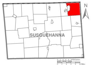
Harmony Township is a township in Susquehanna County, Pennsylvania, United States. The population was 512 at the 2020 census.

<span class="mw-page-title-main">Scipio, Utah</span> Town in the state of Utah, United States

Scipio is a town on the eastern edge of Millard County, Utah, United States. The population was 290 at the 2000 census.

<span class="mw-page-title-main">Gretna, Virginia</span> Town in Virginia, United States

Gretna is a town in Pittsylvania County, Virginia, United States. The population was 1,267 at the 2010 census. It is part of the Danville Micropolitan Statistical Area.

Perrysburg is a town in Cattaraugus County, New York, United States. The population was 1,515 at the 2020 census. The town is named after Commodore Oliver Hazard Perry and is located in the northwest corner of the county. The town contains the census-designated place also named Perrysburg, formerly an incorporated village.

Lakewood is a village in Chautauqua County, New York, United States. The population was 2,993 at the 2020 census. The village is in the northern part of the town of Busti.

Maple Valley Township is a civil township of Montcalm County in the U.S. state of Michigan. The population was 1,908 at the 2020 census.

References

  1. "ArcGIS REST Services Directory". United States Census Bureau. Retrieved September 20, 2022.
  2. 1 2 Bureau, US Census. "City and Town Population Totals: 2020-2021". Census.gov. US Census Bureau. Retrieved July 5, 2022.
  3. The Church of Jesus Christ of Latter-Day Saints: Doctrine and covenants revelation sites, The Church of Jesus Christ of Latter-Day Saints, Steve Mortensen, p. 66, 2005, Retrieved November 22, 2013.
  4. The Church of Jesus Christ of Latter-Day Saints: The Doctrine and covenants: Scriptures: Section 100, The Church of Jesus Christ of Latter-Day Saints, 2013, Retrieved November 22, 2013.
  5. "US Gazetteer files: 2010, 2000, and 1990". United States Census Bureau. February 12, 2011. Retrieved April 23, 2011.
  6. "Geographic Identifiers: 2010 Demographic Profile Data (G001): South Dayton village, New York". U.S. Census Bureau, American Factfinder. Archived from the original on February 12, 2020. Retrieved October 29, 2014.
  7. "Census of Population and Housing". Census.gov. Retrieved June 4, 2016.
  8. "U.S. Census website". United States Census Bureau . Retrieved January 31, 2008.
  9. "Bill Bergey". databaseFootball.com. Archived from the original on April 8, 2013. Retrieved June 5, 2013.
  10. "RECORD BOOKS". New York State Public High School Athletic Association. Archived from the original on June 19, 2021.
  11. "Unofficial Minutes of the February 16, 2012 Board of Education meeting" (PDF). Pine Valley Central School District. February 16, 2012.
  12. "Pine Valley's Nobles to be Inducted into Section VI HOF".
  13. "Clarence Bee".