Portville (village), New York

Last updated
Portville, New York
Portville Post Office Apr 10.JPG
U.S. Post Office, Portville, NY, April 2010
USA New York location map.svg
Red pog.svg
Portville
Location within the state of New York
Coordinates: 42°2′14″N78°20′12″W / 42.03722°N 78.33667°W / 42.03722; -78.33667 Coordinates: 42°2′14″N78°20′12″W / 42.03722°N 78.33667°W / 42.03722; -78.33667
Country United States
State New York
County Cattaraugus
Town Portville
Area
[1]
  Total0.80 sq mi (2.08 km2)
  Land0.80 sq mi (2.08 km2)
  Water0.00 sq mi (0.00 km2)
Elevation
1,430 ft (436 m)
Population
 (2020)
  Total892
  Density1,112.22/sq mi (429.40/km2)
Time zone UTC-5 (Eastern (EST))
  Summer (DST) UTC-4 (EDT)
ZIP code
14770
Area code 716
FIPS code 36-59498
GNIS feature ID0961005
Website www.portvilleny.net

Portville is a village in Cattaraugus County, New York, United States. It is in the southern part of the town of Portville and southeast of Olean. The village population was 916 at the 2020 census, [2] out of a population of 3,730 in the entire town of Portville.

Contents

History

The community, located along the Allegheny River, was first settled in 1813, with the village of Portville being incorporated in 1895. [3] The former Genesee Valley Canal reached its southern terminus at Portville. A fire destroyed most of the business district in 1875. The village was incorporated in 1895. Portville Free Library and William E. Wheeler House are listed on the National Register of Historic Places. [4]

Notable people

Geography

According to the United States Census Bureau, the village has a total area of 0.81 square miles (2.1 km2), all land. The village is on the east side of the Allegheny River and is split by Dodge Creek, which flows into the river. [5]

New York State Route 305 and New York State Route 417 pass through the village.

Demographics

Historical population
CensusPop.
1870 450
1880 68351.8%
1900 748
1910 7581.3%
1920 606−20.1%
1930 96959.9%
1940 1,0185.1%
1950 1,15113.1%
1960 1,33616.1%
1970 1,304−2.4%
1980 1,136−12.9%
1990 1,040−8.5%
2000 1,024−1.5%
2010 1,014−1.0%
2020 892−12.0%
2021 (est.)907 [2] 1.7%
U.S. Decennial Census [6]

As of the census [7] of 2000, there were 1,024 people, 416 households, and 270 families residing in the village. The population density was 1,261.8 people per square mile (488.1/km2). There were 454 housing units at an average density of 559.4 per square mile (216.4/km2). The racial makeup of the village was 98.54% White, 0.59% Black or African American, 0.20% Native American, 0.29% from other races, and 0.39% from two or more races. Hispanic or Latino people of any race were 0.39% of the population.

There were 416 households, out of which 35.8% had children under the age of 18 living with them, 48.6% were married couples living together, 13.5% had a female householder with no husband present, and 34.9% were non-families. 32.2% of all households were made up of individuals, and 20.0% had someone living alone who was 65 years of age or older. The average household size was 2.46 and the average family size was 3.11.

In the village, the population was spread out, with 29.7% under the age of 18, 7.1% from 18 to 24, 25.1% from 25 to 44, 20.0% from 45 to 64, and 18.1% who were 65 years of age or older. The median age was 37 years. For every 100 females, there were 80.0 males. For every 100 females age 18 and over, there were 79.6 males.

The median income for a household in the village was $31,210, and the median income for a family was $40,060. Males had a median income of $30,885 versus $21,563 for females. The per capita income for the village was $16,166. About 11.1% of families and 14.8% of the population were below the poverty line, including 21.8% of those under age 18 and 13.3% of those age 65 or over.

Related Research Articles

<span class="mw-page-title-main">Clarksville, Allegany County, New York</span> Town in New York, United States

Clarksville is a town located in Allegany County, New York, United States. As of the 2010 census, the town had a total population of 1,161. The town is named after S.N. Clark, an agent of the Holland Land Company.

<span class="mw-page-title-main">Hinsdale, New York</span> Town in New York, United States

Hinsdale is a town in Cattaraugus County, New York, United States. The population was 2,119 at the 2020 census. The town was named after Hinsdale in New Hampshire.

Weston Mills is a hamlet in the towns of Portville and Olean in Cattaraugus County, New York, United States. It is counted as a census-designated place by the U.S. Census Bureau, which recorded a population of 1,472 at the 2010 census.

Brocton is a village in Chautauqua County, New York, United States. The name was derived by combining the names "Brockway" and "Minton", two prominent local families. The population was 1,335 at the 2020 census. Brocton is within the town of Portland.

<span class="mw-page-title-main">French Creek, New York</span> Town in New York, United States

French Creek is a town in Chautauqua County, New York, United States. The population was 997 at the 2020 census. The town is named after the stream flowing through it, which ultimately flows to the Allegheny River in Pennsylvania. The town of French Creek is located in the far southwestern corner of the state.

Munsons Corners is a hamlet and census-designated place (CDP) in Cortland County, New York, United States. The population was 2,728 at the 2010 census.

Harpersfield is a town in Delaware County, New York, United States. The population was 1,577 at the 2010 census. The town is on the northern border of the county.

<span class="mw-page-title-main">Village of the Branch, New York</span> Village in New York, United States

Village of the Branch is a village in the Town of Smithtown in Suffolk County, New York, United States. The population was 1,807 at the 2010 census. The village incorporated in 1927.

<span class="mw-page-title-main">Haysville, Pennsylvania</span> Borough in Pennsylvania, United States

Haysville is a borough in Allegheny County, Pennsylvania, U.S., along the Ohio River. The population was 70 according to the 2010 census, making it the least-populated municipality in Allegheny County.

<span class="mw-page-title-main">Allegany Township, Potter County, Pennsylvania</span> Township in Pennsylvania, United States

Allegany Township is a township in Potter County, Pennsylvania, United States. The population was 397 at the 2020 census.

<span class="mw-page-title-main">Watson Township, Warren County, Pennsylvania</span> Township in Pennsylvania, United States

Watson Township is a township in Warren County, Pennsylvania, United States. The population was 231 at the 2020 census, down from 274 at the 2010 census.

<span class="mw-page-title-main">Bruceton Mills, West Virginia</span> Town in West Virginia, United States

Bruceton Mills is a town in Preston County, West Virginia, United States along Big Sandy Creek. The population was 64 at the 2020 census. The Penitentiary for Federal Prisoners-Hazelton is located in Bruceton Mills.

<span class="mw-page-title-main">Newburg, West Virginia</span> Town in West Virginia, United States

Newburg is a town in Preston County, West Virginia, United States. The population was 275 at the 2020 census.

<span class="mw-page-title-main">Rockdale, Wisconsin</span> Village in Wisconsin, United States

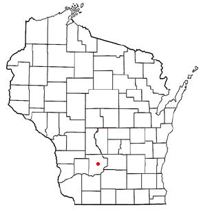
Rockdale is a village in Dane County, Wisconsin, United States. The population was 214 at the 2010 census. The village is split in half by the Koshkonong Creek. It is part of the Madison Metropolitan Statistical Area.

<span class="mw-page-title-main">Freedom, Sauk County, Wisconsin</span> Town in Wisconsin, United States

Freedom is a town in Sauk County, Wisconsin, United States. The population was 416 at the 2000 census. The unincorporated community of La Rue is located within the town. The town was named from the American ideal of freedom.

Allegany is a village in Cattaraugus County, New York, United States. The population was 1,596 at the 2020 census. The village is in the eastern part of the town of Allegany, west of the city of Olean.

Olean is a town in Cattaraugus County, New York, United States. The population was 1,890 at the 2020 census. The name is derived from the Latin word "oleum" due to the discovery of crude oil in nearby Ischua.

<span class="mw-page-title-main">Portville, New York</span> Town in New York, United States

Portville is a town in Cattaraugus County, New York, United States. The population was 3,504 at the 2020 census. The name is derived from the town's early role in shipping lumber and other items down the Allegheny River. It was formed in 1837 from the town of Olean.

<span class="mw-page-title-main">Hannibal (village), New York</span> Village in New York, United States

Hannibal is a village in Oswego County, New York, United States. The population was 555 at the 2010 census. The village is named after Hannibal, the hero of ancient Carthage.

<span class="mw-page-title-main">Milltown, Wisconsin</span> Village in Wisconsin, United States

Milltown is a village in Polk County, Wisconsin, United States. The population was 917 at the 2010 census. The village is located within the Town of Milltown.

References

  1. "ArcGIS REST Services Directory". United States Census Bureau. Retrieved September 20, 2022.
  2. 1 2 Bureau, US Census. "City and Town Population Totals: 2020-2021". Census.gov. US Census Bureau. Retrieved 5 July 2022.
  3. "Home". www.portvilleny.net. Retrieved 2018-10-23.
  4. "National Register Information System". National Register of Historic Places . National Park Service. March 13, 2009.
  5. "Geographic Identifiers: 2010 Demographic Profile Data (G001): Portville village, New York". U.S. Census Bureau, American Factfinder. Archived from the original on February 12, 2020. Retrieved October 29, 2014.
  6. "Census of Population and Housing". Census.gov. Retrieved June 4, 2016.
  7. "U.S. Census website". United States Census Bureau . Retrieved 2008-01-31.