South Trenton, New Jersey

Last updated

South Trenton
2016-02-23 13 40 54 View south along Second Street near Cliff Street in the South Trenton section of Trenton, New Jersey.jpg
Second Street in South Trenton
Location map of Mercer County, New Jersey.svg
Red pog.svg
South Trenton
Location of South Trenton in Mercer County Inset: Location of county within the state of New Jersey
USA New Jersey location map.svg
Red pog.svg
South Trenton
South Trenton (New Jersey)
Usa edcp location map.svg
Red pog.svg
South Trenton
South Trenton (the United States)
Coordinates: 40°11′59″N74°45′20″W / 40.19972°N 74.75556°W / 40.19972; -74.75556
Country Flag of the United States.svg  United States
State Flag of New Jersey.svg  New Jersey
County Mercer
City Trenton

South Trenton is a neighborhood located within the city of Trenton in Mercer County, in the U.S. state of New Jersey. [1] [2] It is home to Italian Americans, Latin Americans, Irish Americans and their descendants. South Trenton borders Hamilton Township to the southeast and the Delaware River to the west. It had a brief existence as an independent municipality from 1840 to 1851.

Contents

South Trenton was incorporated as a borough by an act of the New Jersey Legislature on February 28, 1840, from portions of Nottingham Township. The borough was annexed by Trenton on April 14, 1851. [3] [4]

South Trenton is home to Trenton's Chambersburg neighborhood also known as The 'Burg'. [5] Its population includes a large immigrant community from Poland, Slovakia, Ireland, Hungary, Ukraine, and Germany, though eventually mostly Italian immigrants and their offspring came to dominate the neighborhood, and it has since been known for its Italian-American population. It is also known for being the Restaurant District of Trenton with many of the restaurants in the neighborhood specializing in Italian cuisine. Chambersburg also hosts the annual Italian celebration called the Feast of Madonna or the Feast of Lights, further reflecting its cultural and religious roots. In recent years, South Trenton has been experiencing a sharp rise in residents from Latin America, especially Puerto Rico. There are still large concentrations of Puerto Ricans in South Trenton. More recently, Guatemalan, Costa Rican, and Ecuadorian immigrants have come to the neighborhood. Many have set up new stores and businesses alongside Italian-Americans. Today, South Broad St. in South Trenton is home to Trenton's largest population of Latinos.

Landmarks

A sign for the Italian Peoples Bakery on Butler Street, a neighborhood landmark Italian People's Bakery.jpg
A sign for the Italian Peoples Bakery on Butler Street, a neighborhood landmark
Arm & Hammer Park Mercer County Waterfront Park.jpg
Arm & Hammer Park

Landmarks in South Trenton include the First Baptist Church of Trenton located at the corner of Centre and Bridge Street which was founded in 1805. The Sun National Bank Center was completed in 1999 and hosts hundreds of events per year from hockey games to musical concerts to job fairs as well as the very popular PrimeTime Shootout showcasing some of the nation's best talent in high school basketball. The 2003 PrimeTime Shootout was the site of the highest-scoring game of LeBron James' high school career. It is located at the corner of South Broad St. and Hamilton Ave. The Trenton Thunder's stadium, Arm & Hammer Park, is located at the end of Cass Street (nicknamed "Thunder Road"). It is the Class AA-affiliate of the New York Yankees (formerly the Detroit Tigers and the Boston Red Sox) and counts Tony Clark, Carl Pavano, Trot Nixon, Nomar Garciaparra, David Eckstein, Dioner Navarro, Chen Ming-Wing, Phil Hughes, Robinson Cano, Melky Cabrera, Joba Chamberlain, Ian Kennedy, Bret Saberhagen, Derek Jeter, Bernie Williams, and Roger Clemens (the latter four as injury rehabs). There were two other Trenton minor league teams: the Trenton Senators and the Trenton Giants. The Trenton Giants once had Willie Mays (see Say Hey: The Autobiography of Willie Mays, by Willie Mays with Lou Sahadi, copyright 1988, starting at p. 46) among its former players. The New Jersey State Prison (NJSP) is also located in South Trenton mainly along 2nd St. and has a mural dedicated to the Trenton Thunder along its side that faces Thunder Road.

Another very famous landmark of South Trenton and Chambersburg is the famed and renowned Italian Peoples Bakery. Known as the "Pride of Chambersburg", it has served the neighborhood bread and Italian baked goods for over 80 years. It is still owned and operated by descendants of the same family that started the business in 1936. They now have several locations in New Jersey and Pennsylvania, but their main location is in the Heart of Chambersburg at 61-63 Butler Street, near the Italian Banquet Hall Roman Hall, and near St Joachims Catholic Church and many other Chambersburg businesses. [6] [7]

History

Roebling Machine Shop, oldest building in the Roebling complex, now a museum space Roebling Shop side.JPG
Roebling Machine Shop, oldest building in the Roebling complex, now a museum space

In April 1828, all South Trenton from the Assunpink southward was included in Nottingham Township. Trenton was considered the section north of the creek. Nottingham was divided, however, on April 11, 1842, the territory set off being thenceforth known as Hamilton Township.

In 1831, John A. Roebling migrated from Germany, moving to Trenton in about 1848, when he purchased some acres of land on South Broad Street where his new wire plant would be located.

In 1851, South Trenton was annexed as part of Trenton. This also included the areas of Mill Hill and Bloomsbury. 5 years later, the part of Hamilton known as Lamberton was annexed as well. Mill Hill was the sight of some of the earliest known industrial development in Trenton. Residents were mostly working and middle class: industrial workers, clerks, shopkeepers, teachers and government workers. Mill Hill grew rapidly in the second half of the nineteenth century, with some decline toward the end of the century. An analysis of households based on city directories of this period charts the composition of the neighborhood.

Many people consider Chambersburg part of South Trenton and call the area of the Streets of Lamberton, Cass, and Centre as "The Bottom" because of its urban area and the rise in crime along these streets.

Related Research Articles

<span class="mw-page-title-main">Trenton, New Jersey</span> Capital city of New Jersey, United States

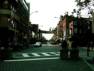
Trenton is the capital city of the U.S. state of New Jersey and the seat of Mercer County. It was the capital of the United States from November 1 until December 24, 1784. Trenton and Princeton are the two principal cities of the Trenton–Princeton metropolitan statistical area, which encompasses those cities and all of Mercer County for statistical purposes and constitutes part of the New York combined statistical area by the U.S. Census Bureau. However, Trenton directly borders the Philadelphia metropolitan area to its west, and the city was part of the Philadelphia combined statistical area from 1990 until 2000.

<span class="mw-page-title-main">Mercer County, New Jersey</span> County in New Jersey, United States

Mercer County is a county located in the U.S. state of New Jersey. Its county seat is Trenton, also the state capital, prompting its nickname The Capital County. Mercer County alone constitutes the Trenton–Princeton metropolitan statistical area and is considered part of the New York combined statistical area by the U.S. Census Bureau, but also directly borders the Philadelphia metropolitan area and is included within the Federal Communications Commission's Philadelphia Designated Media Market Area. The county is part of the Central Jersey region of the state.

<span class="mw-page-title-main">New Jersey Route 29</span> Highway in New Jersey

Route 29 is a state highway in the U.S. state of New Jersey. Signed north-south, it runs 34.76 mi (55.94 km) from an interchange with Interstate 295 (I-295) in Hamilton Township in Mercer County, where the road continues east as I-195, northwest to Route 12 in Frenchtown, Hunterdon County. Between the southern terminus and I-295 in Ewing Township, the route is a mix of freeway and expressway that runs along the Delaware River through Trenton. This section includes a truck-restricted tunnel that was built along the river near historic houses and Riverview Cemetery. North of I-295, Route 29 turns into a scenic and mostly two-lane highway. North of the South Trenton Tunnel, it is designated the Delaware River Scenic Byway, a New Jersey Scenic Byway and National Scenic Byway, that follows the Delaware River in mostly rural sections of Mercer County and Hunterdon County. The obsolete Delaware & Raritan Canal usually stands between the river and the highway. Most sections of this portion of Route 29 are completely shaded due to the tree canopy. Route 29 also has a spur, Route 129, which connects Route 29 to U.S. Route 1 (US 1) in Trenton.

<span class="mw-page-title-main">New Jersey Route 129</span> State highway in New Jersey, US

Route 129 is a major arterial boulevard state highway in the capital city of Trenton, New Jersey. The highway runs along Canal Boulevard, a four-lane arterial through portions of Trenton, serving as an alternative highway to its parent, Route 29. The route begins at an intersection with Lamberton Road in Hamilton Township, heads northward along NJ Transit's River Line until terminating at an interchange with U.S. Route 1.

<span class="mw-page-title-main">Overbrook Park, Philadelphia</span> Neighborhood of Philadelphia in Pennsylvania, United States

Overbrook Park is a neighborhood in the West Philadelphia section of Philadelphia, Pennsylvania, United States. It was founded in the 1940s on the site of a former farm known as Supio's farm, offering new housing for returning GIs and their families. Overbrook Park is a largely middle-class African-American and historically Jewish-American neighborhood.

<span class="mw-page-title-main">North Trenton, New Jersey</span> Populated place in Mercer County, New Jersey, US

North Trenton is a neighborhood located within the city of Trenton in Mercer County, in the U.S. state of New Jersey.

<span class="mw-page-title-main">Tacony, Philadelphia</span> Neighborhood of Philadelphia in Philadelphia County, Pennsylvania, United States

Tacony is a historic neighborhood in Northeast Philadelphia, United States, approximately 8 miles (13 km) from downtown Philadelphia. It is bounded by the east side of Frankford Avenue on the northwest, the south side of Cottman Avenue on the northeast, the north side of Robbins Street on the southwest, and the Delaware River and Interstate 95 on the southeast.

<span class="mw-page-title-main">Lamberton, New Jersey</span> Populated place in Camden County, New Jersey, US

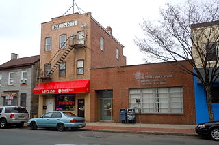
Lamberton was the name of a port community on the Delaware River in Mercer County, in the U.S. state of New Jersey. It was annexed by the city of Trenton as part of South Trenton in 1856. It is now known simply as Waterfront.

<span class="mw-page-title-main">Lamington, New Jersey</span> Populated place in Somerset County, New Jersey, US

Lamington is an unincorporated community and census-designated place (CDP) located within Bedminster Township in Somerset County, in the U.S. state of New Jersey. It contains the Lamington Presbyterian Church Cemetery and the Lamington Black Cemetery.

<span class="mw-page-title-main">East Trenton, New Jersey</span> Populated place in Mercer County, New Jersey, US

East Trenton is a neighborhood located within the city of Trenton in Mercer County, in the U.S. state of New Jersey. It borders Hamilton Township and is home to a sizable African-American community, besides having small pockets of Latinos and Italians.

Nottingham Township was a township that existed for almost 168 years in New Jersey, from 1688 until it was dissolved in 1856.

<span class="mw-page-title-main">Chambersburg, Trenton, New Jersey</span> Populated place in Mercer County, New Jersey, US

Chambersburg is a neighborhood located within the city of Trenton in Mercer County, in the U.S. state of New Jersey. It is considered part of South Trenton. Chambersburg was an independent municipality from 1872 to 1888.

<span class="mw-page-title-main">Elijah C. Hutchinson</span> American politician (1855–1932)

Elijah Cubberley Hutchinson was an American Republican Party politician who represented New Jersey's 4th congressional district from 1915 to 1923.

<span class="mw-page-title-main">Mill Hill, Trenton, New Jersey</span> Populated place in Mercer County, New Jersey, US

Mill Hill is a historic neighborhood located within the city of Trenton in Mercer County, in the U.S. state of New Jersey. It is considered to be part of Downtown Trenton. The Mill Hill Historic District was added to the National Register of Historic Places in 1977.

<span class="mw-page-title-main">Harsimus</span> Populated place in Hudson County, New Jersey, US

Harsimus is a neighborhood within Downtown Jersey City, Hudson County, in the U.S. state of New Jersey. The neighborhood stretches from the Harsimus Stem Embankment on the north to Christopher Columbus Drive on the south between Coles Street and Grove Street or more broadly, to Marin Boulevard. It borders the neighborhoods of Hamilton Park to the north, Van Vorst Park to the south, the Village to the west, and the Powerhouse Arts District to the east. Newark Avenue has traditionally been its main street. The name is from the Lenape, used by the Hackensack Indians who inhabited the region and could be translated as Crow’s Marsh. From many years, the neighborhood was part of the "Horseshoe", a political delineation created by its position between the converging rail lines and political gerrymandering.

<span class="mw-page-title-main">Van Vorst Park</span> Populated place in Essex County, New Jersey, US

Van Vorst Park is a neighborhood in the Historic Downtown of Jersey City, Hudson County, New Jersey, centered on a park sharing the same name. The neighborhood is located west of Paulus Hook and Marin Boulevard, north of Grand Street, east of the Turnpike Extension, and south of The Village and Christopher Columbus Drive. Much of it is included in the Van Vorst Park Historical District.

<span class="mw-page-title-main">Italian Peoples Bakery</span> Bakeries of the United States

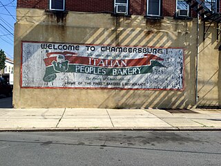
Italian Peoples Bakery is a bakery and delicatessen founded in 1936 and located in the Chambersburg neighborhood of Trenton, New Jersey. The bakery expanded to wholesale distribution of products and now serves parts of Pennsylvania and New Jersey.

<span class="mw-page-title-main">Duck Island, New Jersey</span> Populated place in Mercer County, New Jersey, US

Duck Island is an unincorporated community located along the border of Hamilton Township and the city of Trenton in Mercer County, in the U.S. state of New Jersey. The community takes its name from Duck Island, which extends southeastward from the community. The city of Trenton provides public docks for fishing in Duck Island.

<span class="mw-page-title-main">Top Road, Trenton, New Jersey</span> Populated place in Mercer County, New Jersey, US

Top Road is a neighborhood located within the city of Trenton in Mercer County, in the U.S. state of New Jersey. Much of Top Road was once part of Lawrence Township and then was added to the now-defunct Millham Township before being annexed by Trenton in 1888.

<span class="mw-page-title-main">John A. Roebling's Sons Company, Trenton N.J., Block 3</span> United States historic place

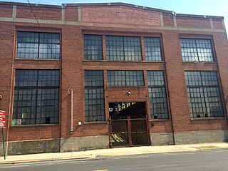
John A. Roebling's Sons Company, Trenton N.J., Block 3 is the northern portion of the former Roebling manufacturing complex in Trenton, New Jersey. The buildings date from 1908–1929 and the site was added to the National Register of Historic Places on August 22, 2012.

References

  1. Google (January 10, 2015). "South Trenton, New Jersey" (Map). Google Maps . Google. Retrieved January 10, 2015.
  2. "City Profile Report: Trenton 250: 1792-2042: A City Master Plan Document" (PDF). City of Trenton. Archived from the original (PDF) on January 21, 2015. Retrieved January 20, 2015.
  3. "The Story of New Jersey's Civil Boundaries: 1606-1968", John P. Snyder, Bureau of Geology and Topography; Trenton, New Jersey; 1969. p. 164.
  4. Chronology of Important Events. Accessed March 25, 2007.
  5. Fessler, Pam. "Stephanie Plum: Trenton's Scrappy Bounty Hunter", NPR, August 9, 2010. Accessed December 25, 2022. "The Italian Peoples Bakery has been around for four generations in the city's Italian section -- Chambersburg, better known as the 'Burg.'"
  6. Italian Peoples Bakery
  7. "Look Who's Talking: Carmen Guagliardo, president and GM of Italian Peoples Bakery". The Trentonian . Archived from the original on February 17, 2012. Retrieved July 5, 2023.