South Yuba City, California

Last updated

South Yuba City, California
Sutter County California Incorporated and Unincorporated areas South Yuba City Highlighted.svg
Location in Sutter County and the state of California
Coordinates: 39°6′44″N121°38′20″W / 39.11222°N 121.63889°W / 39.11222; -121.63889
Country United States
State California
County Sutter
Area
  Total3.2 sq mi (8.4 km2)
  Land3.2 sq mi (8.4 km2)
  Water0 sq mi (0 km2)
Elevation
52 ft (16 m)
Population
 (2000)
  Total12,651
  Density3,953.4/sq mi (1,506.1/km2)
Time zone UTC-8 (Pacific (PST))
  Summer (DST) UTC-7 (PDT)
ZIP code
95991
Area code 530
FIPS code 06-73472
GNIS feature ID1867060

South Yuba City is an unincorporated community and former census-designated place (CDP) in Sutter County, California, United States. [1] It is part of the Yuba City Metropolitan Statistical Area within the Greater Sacramento CSA. The population was 12,651 at the 2000 census.

Contents

Geography

South Yuba City is located at 39°6′44″N121°38′20″W / 39.11222°N 121.63889°W / 39.11222; -121.63889 (39.112192, -121.638976). [2]

According to the United States Census Bureau, the CDP has a total area of 3.2 square miles (8.3 km2), all of it land.

Demographics

As of the census [3] of 2000, there were 12,651 people, 4,026 households, and 3,345 families residing in the CDP. The population density was 3,908.7 inhabitants per square mile (1,509.2/km2). There were 4,144 housing units at an average density of 1,280.3 per square mile (494.3/km2). The racial makeup of the CDP was 63.95% White, 1.68% African American, 0.91% Native American, 22.95% Asian, 0.23% Pacific Islander, 6.15% from other races, and 4.13% from two or more races. Hispanic or Latino of any race were 11.86% of the population.

There were 4,026 households, out of which 42.1% had children under the age of 18 living with them, 70.6% were married couples living together, 8.4% had a female householder with no husband present, and 16.9% were non-families. 13.3% of all households were made up of individuals, and 5.0% had someone living alone who was 65 years of age or older. The average household size was 3.13 and the average family size was 3.45.

In the CDP, the population was spread out, with 29.7% under the age of 18, 7.1% from 18 to 24, 28.7% from 25 to 44, 23.8% from 45 to 64, and 10.8% who were 65 years of age or older. The median age was 35 years. For every 100 females, there were 96.9 males. For every 100 females age 18 and over, there were 93.5 males.

The median income for a household in the CDP was $54,518, and the median income for a family was $59,886. Males had a median income of $40,574 versus $31,265 for females. The per capita income for the CDP was $21,423. About 4.9% of families and 5.8% of the population were below the poverty line, including 7.5% of those under age 18 and 6.4% of those age 65 or over.

Media

MySYtv.com provides television coverage of local events in the area.

Politics

In the state legislature, South Yuba City is in the 4th Senate District, represented by Republican Doug LaMalfa, and in the 2nd Assembly District, represented by Republican Jim Nielsen.

Federally, South Yuba City is in California's 3rd congressional district , represented by Republican Kevin Kiley. [4]

Related Research Articles

<span class="mw-page-title-main">Sutter County, California</span> County in California, United States

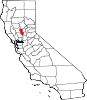
Sutter County is a county located in the U.S. state of California. As of the 2020 census, the population was 99,633. The county seat is Yuba City. Sutter County is included in the Yuba City, CA Metropolitan Statistical Area as well as the Sacramento-Roseville, CA Combined Statistical Area. The county is located along the Sacramento River in the Sacramento Valley.

<span class="mw-page-title-main">Yuba County, California</span> County in California, United States

Yuba County is located in north-central Central Valley, California, United States. As of the 2020 U.S. Census, its population was 81,575. Yuba County is included in the Yuba City metropolitan statistical area, which is also included in the Sacramento–Roseville combined statistical area. The county is in the Central Valley region along the Feather River; the county seat is Marysville.

<span class="mw-page-title-main">Penn Valley, California</span> Census-designated place in California, United States

Penn Valley is a census-designated place (CDP) in Nevada County, California. The population was 1,621 at the 2010 census, up from 1,387 at the 2000 census. The large Lake Wildwood master-planned community, although a separate CDP, has a Penn Valley postal address, and is sometimes considered part of the general Penn Valley community.

<span class="mw-page-title-main">Clio, California</span> Census-designated place in California, United States

Clio is a census-designated place in Plumas County, California, United States. Clio is located 23 miles (37.0 km) southeast of Quincy. The population was 66 at the 2010 census, down from 90 at the 2000 census.

<span class="mw-page-title-main">Lake Almanor Country Club, California</span> Census-designated place in California, United States

Lake Almanor Country Club is a census-designated place (CDP) in Plumas County, California, United States. The population was 419 at the 2010 census, down from 847 at the 2000 census. The ZIP code for the CDP is 96137.

<span class="mw-page-title-main">Meadow Valley, California</span> Census-designated place in California, United States

Meadow Valley is a census-designated place (CDP) in Plumas County, California, United States. The population was 453 at the 2020 census, down from 464 at the 2010 census.

<span class="mw-page-title-main">Tobin, California</span> Census-designated place in California, United States

Tobin is a census-designated place (CDP) in Plumas County, California, United States. The population was 12 at the 2010 census, up from 11 at the 2000 census.

<span class="mw-page-title-main">La Riviera, California</span> Census-designated place in California, United States

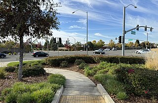
La Riviera is a census-designated place (CDP) in Sacramento County, California, United States. It is part of the Sacramento–Arden-Arcade–Roseville Metropolitan Statistical Area. The population was 10,802 at the 2010 census, up from 10,273 at the 2000 census. La Riviera is a primarily residential neighborhood located between the American River on the North side and Highway 50 on the southern border.

<span class="mw-page-title-main">Parkway–South Sacramento, California</span> Unincorporated community in California, United States

Parkway–South Sacramento is a former census-designated place (CDP) in Sacramento County, California, United States. It is part of the Sacramento–Arden-Arcade–Roseville Metropolitan Statistical Area. The area shares three boundaries with the City of Sacramento. The population was 36,468 at the 2000 census.

<span class="mw-page-title-main">Live Oak, Sutter County, California</span> City in California, United States

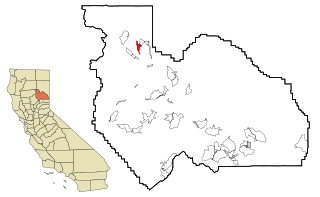
Live Oak is an incorporated city in Sutter County, California, United States. It is part of the Yuba City Metropolitan Statistical Area within the Greater Sacramento CSA, and includes a hamlet historically named Stafford. The population was 9,106 at the 2020 census, up from 8,392 at the 2010 census.

<span class="mw-page-title-main">Sutter, California</span> Census-designated place in California, United States

Sutter, formerly South Butte and Sutter City, is a census-designated place (CDP) in Sutter County, California, United States. It is part of the Yuba City Metropolitan Statistical Area within the Greater Sacramento CSA. The population as of the 2010 census was 2,904, up from 2,885 at the 2000 census.

<span class="mw-page-title-main">Tierra Buena, California</span> Unincorporated community in California, United States

Tierra Buena was a census-designated place (CDP) in Sutter County, California, United States. It was part of the Yuba City Metropolitan Statistical Area within the Greater Sacramento CSA. The population was 4,587 at the 2000 census, and the CDP has a total area of 3.4 square miles (8.8 km2), all of it land.

<span class="mw-page-title-main">Yuba City, California</span> City in California, United States

Yuba City is a city in Northern California and the county seat of Sutter County, California, United States. The population was 70,117 at the 2020 census. Yuba City is the principal city of the Yuba City Metropolitan Statistical Area which encompasses all of Sutter County and Yuba County. The metro area's population is 164,138. It is the 21st largest metropolitan area in California, ranked behind Redding and Chico. Its metropolitan statistical area is part of the Greater Sacramento CSA.

<span class="mw-page-title-main">Linda, California</span> Census-designated place in California, United States

Linda is a census-designated place (CDP) in Yuba County, California, United States. The population was 17,773 at the 2010 census, up from 13,474 at the 2000 census. Linda is located 2 miles (3.2 km) north-northwest of Olivehurst.

<span class="mw-page-title-main">Loma Rica, California</span> Census-designated place in California, United States

Loma Rica is a census-designated place (CDP) in Yuba County, California, United States. The population was 2,368 at the 2010 census, up from 2,075 at the 2000 census. Loma Rica is located 15 miles (24 km) northeast of Marysville.

<span class="mw-page-title-main">Olivehurst, California</span> CDP in California, United States

Olivehurst is a census-designated place (CDP) in Yuba County, California, United States. The population was 13,656 at the 2010 census, up from 11,061 at the 2000 census. Olivehurst is located 4 miles (6.4 km) south-southeast of Marysville.

<span class="mw-page-title-main">Wheatland, California</span> City in California, United States

Wheatland is the second-largest city by population in Yuba County, California, United States. The population was 3,456 at the 2010 census, up from 2,275 at the 2000 census. Wheatland is located 12.5 miles (20 km) southeast of Marysville.

<span class="mw-page-title-main">Montgomery Creek, California</span> Census-designated place in California, United States

Montgomery Creek is a census-designated place in Shasta County, California, United States. Its population is 176 as of the 2020 census, up from 163 from the 2010 census. The town and associated creek were named after Zachariah Montgomery.

<span class="mw-page-title-main">Challenge–Brownsville, California</span> Census-designated place in California, United States

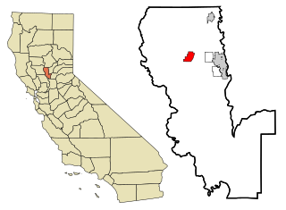
Challenge–Brownsville is a census-designated place (CDP) in Yuba County, California, United States. The population was 1,161 according to the 2020 Census.

<span class="mw-page-title-main">Plumas Lake, California</span> Census-designated place in California, United States

Plumas Lake is a master-planned exurb and census-designated place in Yuba County, California. It is located 30 miles (48 km) north of Sacramento and 10 miles (16 km) south of Marysville off California State Route 70. Its population was 8,126 at the 2020 census.

References

  1. U.S. Geological Survey Geographic Names Information System: South Yuba City, California
  2. "US Gazetteer files: 2010, 2000, and 1990". United States Census Bureau. February 12, 2011. Retrieved April 23, 2011.
  3. "U.S. Census website". United States Census Bureau . Retrieved January 31, 2008.
  4. "California's 3rd Congressional District - Representatives & District Map". Civic Impulse, LLC. Retrieved March 1, 2013.