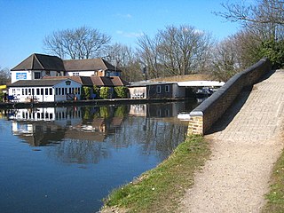
Cowley is a village contiguous with the town of Uxbridge in the London Borough of Hillingdon. A largely suburban village with 16 listed buildings, Cowley is 15.4 miles (24.8 km) west of Charing Cross, bordered to the west by Uxbridge Moor in the Green Belt and the River Colne, forming the border with Buckinghamshire. Cowley was an ancient parish in the historic county of Middlesex.

Uxbridge is a suburban town in west London and the administrative headquarters of the London Borough of Hillingdon. Situated 15.4 miles (24.8 km) west-northwest of Charing Cross, it is one of the major metropolitan centres identified in the London Plan. Uxbridge formed part of the parish of Hillingdon in the county of Middlesex, and was a significant local commercial centre from an early time. As part of the suburban growth of London in the 20th century it expanded and increased in population, becoming a municipal borough in 1955, and has formed part of Greater London since 1965.

Yiewsley is a large suburban village in the London Borough of Hillingdon, England, 2 miles (3 km) south of Uxbridge, the borough's commercial and administrative centre. Yiewsley was a chapelry in the ancient parish of Hillingdon, Middlesex. The population of the ward was 12,979 at the 2011 Census.
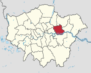
The London Borough of Hillingdon is the largest and westernmost borough in West London, England. It was formed in 1965 from the districts of Hayes and Harlington, Ruislip-Northwood, Uxbridge, and Yiewsley and West Drayton in the ceremonial county of Middlesex. Today, Hillingdon is home to Heathrow Airport and Brunel University, and is the second largest of the 32 London boroughs by area.
The London Borough of Newham is a London borough created in 1965 by the London Government Act 1963. It covers an area previously administered by the Essex county boroughs of West Ham and East Ham, authorities that were both abolished by the same act. The name Newham reflects its creation and combines the compass points of the old borough names. Situated in the Inner London part of East London, Newham has a population of 387,576, which is the fourth highest of the London boroughs and also makes it the 26th most populous district in England. The local authority is Newham London Borough Council.
Ealing is a district in West London, England, 7.5 miles (12.1 km) west of Charing Cross in the London Borough of Ealing. It is the administrative centre of the borough and is identified as a major metropolitan centre in the London Plan.

Daventry is a market town and civil parish in the West Northamptonshire unitary authority area of Northamptonshire, England, close to the border with Warwickshire. At the 2021 Census, Daventry had a population of 28,123, making it the sixth-largest town in Northamptonshire.

Market Drayton is a market town and civil parish on the banks of the River Tern in Shropshire, England. It is close to the Cheshire and Staffordshire borders. It is located between the towns of Whitchurch, Wem, Nantwich, Newcastle-under-Lyme, Newport and the city of Stoke on Trent. The town is on the Shropshire Union Canal and bypassed by the A53 road.

Iver is a civil parish in Buckinghamshire, England. In addition to the central clustered village, the parish includes the residential neighbourhoods of Iver Heath and Richings Park and the hamlets of Shreding Green and Thorney.

Harrow is a large town in Greater London, England, and serves as the principal settlement of the London Borough of Harrow. Lying about 9.5 miles (15.3 km) north-west of Charing Cross and 5.4 miles (8.7 km) south of Watford, the entire town including its localities had a population of 149,246 at the 2011 census, whereas the wider borough had a population of 250,149.

Uxbridge Vine Street station opened on 8 September 1856 as Uxbridge Station and was the earliest of three railway stations in Uxbridge, London.

West Drayton is a suburban town in the London Borough of Hillingdon. It was an ancient parish in the county of Middlesex and from 1929 was part of the Yiewsley and West Drayton Urban District, which became part of Greater London in 1965. The settlement is near the Colne Valley Regional Park and its centre lies 1.9 miles (3 km) north of Heathrow Airport.

RAF West Drayton was a non-flying Royal Air Force station in West Drayton, within the London Borough of Hillingdon, which served as the main centre for military air traffic control in the United Kingdom. It was co-located with the civilian London Air Traffic Control Centre to provide a vital link between civil and military flying and airspace requirements. Following the departure of the remaining civil and military air traffic control systems by 2008, the site was closed and demolished for a new residential development.

Hillingdon Borough Football Club is a semi-professional football club based in Ruislip, in the London Borough of Hillingdon. The club is affiliated to the Middlesex County Football Association. Its name was revived in 1990 from the original club, which had been based in Yiewsley. They currently play in the Combined Counties League Division One.
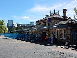
West Drayton railway station serves West Drayton and Yiewsley, western suburbs of London. It is served and managed by the Elizabeth line. It is 13 miles 71 chains (22.3 km) down the line from London Paddington and is situated between Hayes & Harlington to the east and Iver to the west.
Yiewsley and West Drayton was a local government district in Middlesex, England from 1929 to 1965. Its area became the south-west of the London Borough of Hillingdon.
The Uxbridge branch line was a railway line to Uxbridge in the historical English county of Middlesex, from the Great Western Railway main line at West Drayton. It opened in 1856 as a broad gauge single line, 2+1⁄2 miles (4 km) long. It was converted to standard gauge in 1871. Two other branch lines were later built to Uxbridge, but without making a connection.

Stockley Park is a business estate and public country park located between Hayes, Yiewsley and West Drayton in the London Borough of Hillingdon. In August 2020 it was listed in the Register of Historic Parks and Gardens of Special Historic Interest in England as Grade II.
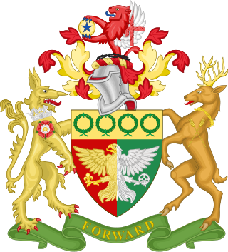
The coat of arms of the London Borough of Hillingdon is the official symbol of the London Borough of Hillingdon. They use elements from the coats of arms of the four previous districts. It is described as:
Arms: Per pale Gules and Vert an Eagle displayed per pale Or and Argent in the dexter claw a Fleur-de-lis Or and in the sinister claw a Cog-Wheel Argent on a Chief Or four Civic Crowns Vert.
Crest: On a Wreath of the Colours issuant from a Circlet of Brushwood Sable a demi-Lion Gules with wings Argent the underside of each wing charged with a Cross Gules and holding between the paws a Bezant thereon a Mullet Azure.
Supporters: On the dexter side an Heraldic Tiger Or gorged with an Astral Crown Azure and charged on the shoulder with a Rose Gules charged with another Argent barbed and seeded proper and on the sinister side a Stag proper attired and gorged with a Circlet of Brushwood and charged on the shoulder with two Ears of Rye slipped in saltire Or.
Motto: Forward.


