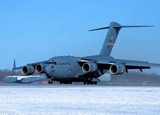
Grand Forks Air Force Base (AFB) (IATA: RDR, ICAO: KRDR, FAA LID: RDR) is a United States Air Force installation in northeastern North Dakota, located north of Emerado and 16 miles (26 km) west of Grand Forks.

Wright-Patterson Air Force Base (WPAFB) is a United States Air Force base and census-designated place just east of Dayton, Ohio, in Greene and Montgomery counties. It includes both Wright and Patterson Fields, which were originally Wilbur Wright Field and Fairfield Aviation General Supply Depot. Patterson Field is approximately 16 kilometres (10 mi) northeast of Dayton; Wright Field is approximately 8.0 kilometres (5 mi) northeast of Dayton.

PAVE PAWS is a complex Cold War early warning radar and computer system developed in 1980 to "detect and characterize a sea-launched ballistic missile attack against the United States". The first solid-state phased array deployed used a pair of Raytheon AN/FPS-115 phased array radar sets at each site to cover an azimuth angle of 240 degrees. Two sites were deployed in 1980 at the periphery of the contiguous United States, then two more in 1987–95 as part of the United States Space Surveillance Network. One system was sold to Taiwan and is still in service.

White Sands Missile Range (WSMR) is a United States Army military testing area and firing range located in the US state of New Mexico. The range was originally established in 1941 as the Alamogordo Bombing and Gunnery Range, where the Trinity test site lay at the northern end of the Range, in Socorro County near the towns of Carrizozo and San Antonio. It then became the White Sands Proving Ground on 9 July 1945.

The Safeguard Program was a U.S. Army anti-ballistic missile (ABM) system designed to protect the U.S. Air Force's Minuteman ICBM silos from attack, thus preserving the US's nuclear deterrent fleet. It was intended primarily to protect against the very small Chinese ICBM fleet, limited Soviet attacks and various other limited-launch scenarios. A full-scale attack by the Soviets would easily overwhelm it. It was designed to allow gradual upgrades to provide similar lightweight coverage over the entire United States over time.

Selfridge Air National Guard Base or Selfridge ANGB is an Air National Guard installation located in Harrison Township, Michigan, near Mount Clemens. Selfridge Field was one of thirty-two Air Service training camps established after the United States entry into World War I in April 1917.

Cavalier Space Force Station, North Dakota, is a United States Space Force installation, where the 10th Space Warning Squadron, Space Delta 4, United States Space Force monitors and tracks potential missile launches against North America with the GE AN/FPQ-16 Enhanced Perimeter Acquisition Radar Attack Characterization System (PARCS). The PARCS also monitors and tracks over half of all earth-orbiting objects to enable space situation awareness and space control. In addition to contractors, NORAD has US and Canadian military members assigned to the facility.

Space Launch Complex 3 (SLC-3) is a launch site at Vandenberg Space Force Base that consists of two separate launch pads. SLC-3E (East) was used by the Atlas V launch vehicle before it was decommissioned in August 2021 with the final launch taking place on November 10,2022 at 09:49, while SLC-3W (West) has been demolished.

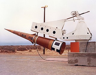
The Sprint was a two-stage, solid-fuel anti-ballistic missile (ABM), armed with a W66 enhanced-radiation thermonuclear warhead used by the United States Army during 1975–76. It was designed to intercept incoming reentry vehicles (RV) after they had descended below an altitude of about 60 kilometres (37 mi), where the thickening air stripped away any decoys or radar reflectors and exposed the RV to observation by radar. As the RV would be traveling at about 5 miles per second, Sprint needed to have phenomenal performance to achieve an interception in the few seconds before the RV reached its target.

The White Alice Communications System was a United States Air Force telecommunication network with 80 radio stations constructed in Alaska during the Cold War. It used tropospheric scatter for over-the-horizon links and microwave relay for shorter line-of-sight links. Sites were characterized by large parabolic, tropospheric scatter antennas as well as smaller microwave dishes for point-to-point links.

White Sands Space Harbor (WSSH) is a spaceport in New Mexico that was formerly used as a Space Shuttle runway, a test site for rocket research, and the primary training area used by NASA for Space Shuttle pilots practicing approaches and landings in the Shuttle Training Aircraft and T-38 Talon aircraft. With its runways, navigational aids, runway lighting, and control facilities, it also served as a backup Shuttle landing site. WSSH is a part of the White Sands Test Facility, and is located approximately 30 miles west of Alamogordo, New Mexico, within the boundaries of the White Sands Missile Range.

Space Launch Complex 10, or Missile Launch Complex 10, is located on Vandenberg Space Force Base in Lompoc, California. It was built in 1958 to test ballistic missiles and developed into a space launching facility in 1963. Prior to 1966 Space Launch Complex 10 West was known as Vandenberg AFB Pad 75-2-6. It remains a rare pristine look at the electronics and facilities created in that era that helped the United States grow its space capabilities.

Cape Cod Space Force Station is a United States Space Force station located in the northwest corner of Joint Base Cape Cod, United States, on Flatrock Hill in Bourne, Massachusetts. Cape Cod Space Force Station began construction in 1976 as Cape Cod Missile Early Warning Station and was renamed Cape Cod Air Force Station in 1982, before assuming its current name in 2021.
Columbia Falls Air Force Station is a closed United States Air Force radar station in Washington County, Maine. Located 16.0 miles (25.7 km) northwest of Machias, Maine and 10.0 miles (16.1 km) north of Columbia Falls, it went operational in 1990 but was closed in 1997 and placed in "warm storage" with minimal maintenance. It was deactivated and placed in "cold storage" in 2002.
Moscow Air Force Station is a closed United States Air Force radar station in Somerset County, Maine. Located 6.0 miles (9.7 km) northeast of Moscow, Maine, it went operational in 1990 but was closed in 1997 and placed in "warm storage" with minimal maintenance. It was deactivated and placed in "cold storage" in 2002.

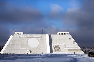
The Don-2N radar is a large missile defense and early warning active electronically scanned array radar outside Moscow, and a key part of the Russian A-135 anti-ballistic missile system designed for the defense of the capital against ballistic missiles. Located near Sofrino in Pushkinsky District of Moscow Oblast, it is a quadrangular frustum 33 m (108 ft) tall with sides 130 m (427 ft) long at the bottom, and 90 m (295 ft) long at the top. Each of its four faces has an 18 m (59 ft) diameter Super high frequency band radar giving 360 degree coverage. To the right of each circular search and track array, separated by a vertical structure for shielding, is a square antenna array for guiding the interceptor missile by data link. The system is run by an Elbrus-2 supercomputer.

The Oscar-Zero Missile Alert Facility near Cooperstown, North Dakota, US was listed on the National Register of Historic Places in 2008. Also known as Oscar-Zero MAF and as O-0 MAF, it exemplifies Utilitarian architecture. The NRHP listing included 2 contributing buildings, 9 contributing structures, and one contributing object.
Air Force Plant Peter J. Kiewit and Sons is a Formerly Used Defense Site (CO7570090038) at the Colorado Front Range and used during the Cold War (1957-1968) to provide "rocket assembly, engine testing, and research and development") for the Titan missile complexes southeast of Denver. The 464 acres (188 ha) of former "Martin Missile Test Site 1" was "deeded" to the USAF in 1957, was subsequently operated by the builder, was listed on the EPA's National Priorities List on November 21, 1989; and remained USAF property until transferred to Lockheed Martin in February 2001. The site is used by, and entirely within, the secure Lockheed Martin/United Launch Alliance Waterton Canyon facility of 5,200 acres (2,100 ha) that produces Titan IV launch vehicles and the GPS III space vehicles. Entirely within the East Fork Brush Creek watershed, the former USAF firearms ranges used by PJKS military police remains along the creek, is managed by the Skyline Hunting and Fishing Club, and is used for periodic Jefferson County police and local Boy Scout training.

The AN/FPQ-16 Perimeter Acquisition Radar Attack Characterization System is a powerful United States Space Force phased-array radar system located in North Dakota. It is the second most powerful phased array radar system in the US Space Force's fleet of missile warning and space surveillance systems, behind the more modern PAVE PAWS phased array radar.

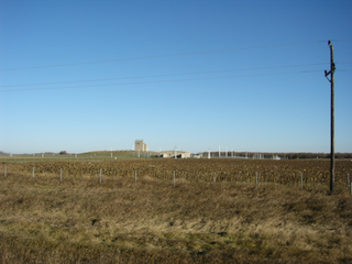
RSL-3, is a Remote Sprint Launch facility in Cavalier County, North Dakota near Concrete. It was listed on the National Register of Historic Places in 2018.


