Stanleytown, Virginia

Last updated

Stanleytown, Virginia
CDP
VAMap-doton-Stanleytown.PNG
Location of Stanleytown, Virginia
Coordinates: 36°45′6″N79°56′55″W / 36.75167°N 79.94861°W / 36.75167; -79.94861
CountryUnited States
State Virginia
County Henry
Area
  Total2.7 sq mi (7.0 km2)
  Land2.7 sq mi (7.0 km2)
  Water0.0 sq mi (0.0 km2)
Elevation
781 ft (238 m)
Population
 (2010)
  Total1,422
  Density530/sq mi (200/km2)
Time zone UTC−5 (Eastern (EST))
  Summer (DST) UTC−4 (EDT)
ZIP code
24168
Area code 276
FIPS code 51-75040 [1]
GNIS feature ID1496253 [2]

Stanleytown is a census-designated place (CDP) in Henry County, Virginia, United States. The population was 1,422 at the 2010 census. It is part of the Martinsville Micropolitan Statistical Area.

Contents

History

Edgewood and Stoneleigh houses are listed on the National Register of Historic Places. [3]

Geography

Stanleytown is located at 36°45′6″N79°56′55″W / 36.75167°N 79.94861°W / 36.75167; -79.94861 (36.751657, 79.948714). [4]

According to the United States Census Bureau, the CDP has a total area of 2.7 square miles (6.9 km2), all of it land.

Demographics

As of the census [1] of 2000, there were 1,515 people, 662 households, and 442 families residing in the CDP. The population density was 564.3 people per square mile (218.3/km2). There were 723 housing units at an average density of 269.3/sq mi (104.2/km2). The racial makeup of the CDP was 88.32% White, 2.57% African American, 0.13% Native American, 0.13% Pacific Islander, 7.46% from other races, and 1.39% from two or more races. Hispanic or Latino of any race were 11.49% of the population.

There were 662 households, out of which 22.7% had children under the age of 18 living with them, 52.0% were married couples living together, 9.4% had a female householder with no husband present, and 33.1% were non-families. 27.9% of all households were made up of individuals, and 14.0% had someone living alone who was 65 years of age or older. The average household size was 2.29 and the average family size was 2.73.

In the CDP, the population was spread out, with 17.8% under the age of 18, 8.8% from 18 to 24, 27.1% from 25 to 44, 25.6% from 45 to 64, and 20.7% who were 65 years of age or older. The median age was 42 years. For every 100 females, there were 105.8 males. For every 100 females age 18 and over, there were 103.9 males.

The median income for a household in the CDP was $32,386, and the median income for a family was $36,927. Males had a median income of $26,164 versus $17,063 for females. The per capita income for the CDP was $18,959. About 12.4% of families and 14.4% of the population were below the poverty line, including 14.7% of those under age 18 and 19.6% of those age 65 or over.

Related Research Articles

<span class="mw-page-title-main">Tara Hills, California</span> Census-designated place in California, United States

Tara Hills is a census-designated place (CDP) in Contra Costa County, California, United States. The population was 5,126 at the 2010 census.

Forest Lake is an unincorporated community and census-designated place (CDP) in Ela Township of Lake County, Illinois, United States. It is about 35 miles (56 km) northwest of downtown Chicago. Per the 2020 census, the population was 1,784. The community was founded in 1935 as a vacation community for Chicago residents.

<span class="mw-page-title-main">West Wareham, Massachusetts</span> Census-designated place in Massachusetts, United States

West Wareham is a census-designated place (CDP) in the town of Wareham in Plymouth County, Massachusetts, United States. The population was 2,064 at the 2010 census.

<span class="mw-page-title-main">Ballantine, Montana</span> CDP in Montana, United States

Ballantine is a census-designated place (CDP) in Yellowstone County, Montana, United States. It lies approximately nine miles (14 km) northeast of Billings on Interstate 94. The population was 346 at the 2000 census. Ballantine, along with the communities of Pompey's Pillar, Worden, and Huntley, is part of the Huntley Project, an irrigation district created by the United States Bureau of Reclamation. The majority of Ballantine's population lives on scattered farms and ranches surrounding the actual townsite.

<span class="mw-page-title-main">Ojo Amarillo, New Mexico</span> CDP in New Mexico, United States

Ojo Amarillo is a census-designated place (CDP) in San Juan County, New Mexico, United States. The population was 829 at the 2000 census. It is part of the Farmington Metropolitan Statistical Area.

<span class="mw-page-title-main">Angola on the Lake, New York</span> Census-designated place in New York, United States

Angola on the Lake is a hamlet and census-designated place (CDP) in Erie County, New York, United States. The population was 1,675 at the 2010 census. It is part of the Buffalo–Niagara Falls Metropolitan Statistical Area.

Elrod is a census-designated place (CDP) in Robeson County, North Carolina, United States. The population was 441 at the 2000 census.

Raemon is a census-designated place (CDP) in Robeson County, North Carolina, United States. The population was 212 at the 2000 census.

<span class="mw-page-title-main">Sequoyah, Oklahoma</span> CDP in Oklahoma, United States

Sequoyah is a census-designated place (CDP) in Rogers County, Oklahoma, United States. The population was 671 at the 2000 census.

<span class="mw-page-title-main">Curtisville, Pennsylvania</span> Census-designated place in Pennsylvania, United States

Curtisville is a census-designated place (CDP) in Allegheny County, Pennsylvania, United States. The population was 1,097 at the 2020 census.

<span class="mw-page-title-main">Orchard Hills, Pennsylvania</span> Census-designated place in Pennsylvania, United States

Orchard Hills is a census-designated place (CDP) in Armstrong County, Pennsylvania, United States. The population was 1,949 at the 2020 census.

<span class="mw-page-title-main">Thorndale, Pennsylvania</span> Census-designated place in Pennsylvania, United States

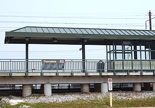
Thorndale is a census-designated place in Chester County, Pennsylvania, United States. The population was 3,407 at the 2010 census. Thorndale is the commercial and administrative center of Caln Township. The community's main street is U.S. Route 30 Business. Many of Thorndale's old houses fell into disrepair from the late 1990s to present and have been torn down and replaced with new businesses. Thorndale is historically notable for containing a summer house of US President James Buchanan, which still stands and has been incorporated into a golf course and turned into a restaurant. The community contains the Thorndale Fire Station and Caln Elementary School, part of the Coatesville Area School District. Thorndale sits along SEPTA's Paoli/Thorndale Line and is currently the last station stop on that line. It is also served by the SEPTA Route 135 bus.

Renningers is a census-designated place (CDP) in Schuylkill County, Pennsylvania, United States. The population was 380 at the 2000 census.

Hasson Heights is a census-designated place (CDP) in Venango County, Pennsylvania, United States. The population was 1,351 at the 2010 census.

<span class="mw-page-title-main">Sheffield, Pennsylvania</span> Census-designated place in Pennsylvania, United States

Sheffield is a census-designated place (CDP) within Sheffield Township in southeastern Warren County, Pennsylvania, United States. It is named after Sheffield, England. The population was 1,123 at the 2010 census.

<span class="mw-page-title-main">Harrison City, Pennsylvania</span> Census-designated place in Pennsylvania, United States

Harrison City is a census-designated place (CDP) in Westmoreland County, Pennsylvania, United States. The population was 174 at the 2020 census.

<span class="mw-page-title-main">Socastee, South Carolina</span> CDP in South Carolina, United States

Socastee is a census-designated place (CDP) in Horry County, South Carolina, United States. The population was 19,952 at the 2010 census.

<span class="mw-page-title-main">Horsepasture, Virginia</span> CDP in Virginia, United States

Horsepasture is a census-designated place (CDP) in Henry County, Virginia, United States. The population was 2,227 at the 2010 census. It is part of the Martinsville Micropolitan Statistical Area.

<span class="mw-page-title-main">Prairie Ridge, Washington</span> CDP in Washington, United States

Prairie Ridge is a census-designated place (CDP) in Pierce County, Washington, United States. The population was 12,288 at the 2020 census.

Lackland Air Force Base CDP is a census-designated place (CDP) covering the permanent residential population of the Lackland Air Force Base in Bexar County, Texas, United States. Per the 2020 census, the population was 9,467.

References

  1. 1 2 "U.S. Census website". United States Census Bureau . Retrieved January 31, 2008.
  2. "US Board on Geographic Names". United States Geological Survey. October 25, 2007. Retrieved January 31, 2008.
  3. "National Register Information System". National Register of Historic Places . National Park Service. July 9, 2010.
  4. "US Gazetteer files: 2010, 2000, and 1990". United States Census Bureau. February 12, 2011. Retrieved April 23, 2011.