Related Research Articles

Lane County is one of the 36 counties in the U.S. state of Oregon. As of the 2020 census, the population was 382,971, making it the fourth-most populous county in Oregon. The county seat is Eugene. It is named in honor of Joseph Lane, Oregon's first territorial governor.

Jackson County is one of the 36 counties in the U.S. state of Oregon. As of the 2020 census, the population was 223,259. The county seat is Medford. The county is named for Andrew Jackson, the seventh president of the United States.

Douglas County is one of the 36 counties in the U.S. state of Oregon. As of the 2020 census, the population was 111,201. The county seat is Roseburg. The county is named after Stephen A. Douglas, an American politician who supported Oregon statehood. Douglas County comprises the Roseburg, OR Micropolitan Statistical Area.

Reedsport is a city in Douglas County, Oregon, United States. As of the 2020 census, the population was 4,310.

Roseburg is a city in the U.S. state of Oregon. It is in the Umpqua River Valley in southern Oregon and is the county seat and most populous city of Douglas County. Founded in 1851, the population was 23,683 at the 2020 census, making it the principal city of the Roseburg, Oregon Micropolitan Statistical Area. The community developed along both sides of the South Umpqua River and is traversed by Interstate 5. Traditionally a lumber industry town, Roseburg was the original home of Roseburg Forest Products, which is now based in nearby Springfield.

The Umpqua River on the Pacific coast of Oregon in the United States is approximately 111 miles (179 km) long. One of the principal rivers of the Oregon Coast and known for bass and shad, the river drains an expansive network of valleys in the mountains west of the Cascade Range and south of the Willamette Valley, from which it is separated by the Calapooya Mountains. From its source northeast of Roseburg, the Umpqua flows northwest through the Oregon Coast Range and empties into the Pacific at Winchester Bay. The river and its tributaries flow almost entirely within Douglas County, which encompasses most of the watershed of the river from the Cascades to the coast. The "Hundred Valleys of the Umpqua" form the heart of the timber industry of southern Oregon, generally centered on Roseburg.

The Smith River is a 90-mile (140 km) tributary of the Umpqua River in the U.S. state of Oregon. It drains 352 square miles (910 km2) of the Central Oregon Coast Range between the watershed of the Umpqua to the south and the Siuslaw River to the north.
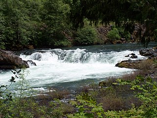
The North Umpqua River is a tributary of the Umpqua River, about 106 miles (171 km) long, in southwestern Oregon in the United States. It drains a scenic and rugged area of the Cascade Range southeast of Eugene, flowing through steep canyons and surrounded by large Douglas-fir forests. Renowned for its emerald green waters, it is considered one of the best fly fishing streams in the Pacific Northwest for anadromous fish.

Steamboat Creek is a short tributary of the North Umpqua River in southwestern Oregon in the United States. Approximately 35 kilometres (22 mi) long, the creek is located on a remote part of the upper North Umpqua in the Calapooia Mountains west of the Cascade Range. It rises in southeastern Lane County at 43.5601214°N 122.5519948°W and flows southwest to join the North Umpqua from the north at Steamboat.

The Calapooya Mountains are a mountain range in Lane and Douglas counties of southwestern Oregon in the United States. The range runs for approximately 60 miles (97 km) west from the Cascade Range between Eugene on the north and Roseburg on the south.
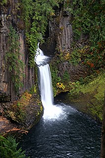
Toketee Falls is a waterfall in Douglas County, Oregon, United States, on the North Umpqua River at its confluence with the Clearwater River. It is located approximately 58 miles (93 km) east of Roseburg near Oregon Route 138.
Winchester is an unincorporated community in Douglas County, Oregon, United States. It is on the south bank of the North Umpqua River 4 miles (6.4 km) north of Roseburg on Interstate 5 and is included in the Roseburg North CDP for statistical purposes.
The Row River is a river, approximately 20 miles (32 km) long, in Lane County, Oregon, United States. It rises in the Cascade Range and flows into the Coast Fork Willamette River near Cottage Grove. The stream was originally known as the "East Fork Coast Fork", but was later renamed after a dispute between neighbors and brothers-in-law George Clark and Joseph Southwell over "trespassing" livestock. Clark was killed as a result of the row. The name rhymes with "cow" rather than with "slow". A post office named Row River operated from 1911 to 1914 a little north of the present site of Dorena at 43.740123°N 122.880347°W.

The history of steamboats on the Oregon Coast begins in the late 19th century. Before the development of modern road and rail networks, transportation on the coast of Oregon was largely water-borne. This article focuses on inland steamboats and similar craft operating in, from south to north on the coast: Rogue River, Coquille River, Coos Bay, Umpqua River, Siuslaw Bay, Yaquina Bay, Siletz River, and Tillamook Bay. The boats were all very small, nothing like the big sternwheelers and propeller boats that ran on the Columbia River or Puget Sound. There were many of them, however, and they came to be known as the "mosquito fleet."

Fort Umpqua was a trading post built by the Hudson's Bay Company in the company's Columbia District, in what is now the U.S. state of Oregon. It was first established in 1832 and moved and rebuilt in 1836.

Washington was an early steamboat operated in the states of California and Oregon. Washington was built in California and was initially operated on the Sacramento River. In 1851, the steamer was purchased and brought on a ship to the Oregon Territory, where it was operated on the Willamette River until the summer of 1853. Washington was sold again, and then transferred to the Oregon coast, where it operated on the Umpqua River, on the Coquille River and on Coos Bay. Washington was able to operate for shorter distances over the open ocean along the Oregon coast. The steamer was wrecked by a boiler explosion in December 1857, near Scottsburg, O.T., on the Umpqua river.
Clearwater is an unincorporated community in Douglas County, Oregon, United States. It is located north of Oregon Route 138 about 43 miles east of Glide, at the confluence of the North Umpqua and Clearwater rivers. It is within the Umpqua National Forest near Toketee Falls and Toketee Lake.
Whitehorse Falls is a 14-foot (4.3 m) waterfall on the Clearwater River, in Douglas County in the U.S. state of Oregon. It is located within the Whitehorse Falls Campground, about 4 miles east of Toketee Lake along Oregon Route 138.
Myrtle Creek is a short tributary of the South Umpqua River in Douglas County in the U.S. state of Oregon. Its main stem, formed by the confluence of two forks just south of the city of Myrtle Creek, is only about 1 mile (1.6 km) long. Its only named tributaries are the two forks, North Myrtle Creek and South Myrtle Creek, each of which is much longer than the main stem.

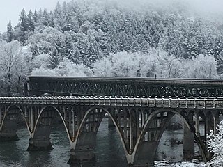
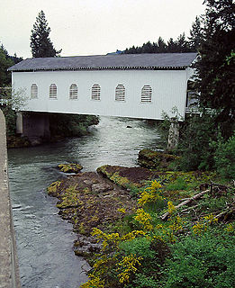
Mott Bridge is a historic timber braced spandrel arch bridge over the North Umpqua River in Douglas County, Oregon, United States. The bridge provides access from Oregon Route 138 to the Mott Trailhead on the North Umpqua Trail.
References
- ↑ "Steamboat". Geographic Names Information System . United States Geological Survey. November 28, 1980. Retrieved 2011-04-07.
- ↑ Oregon Atlas & Gazetteer (7th ed.). Yarmouth, Maine: DeLorme. 2008. p. 54. ISBN 0-89933-347-8.
- 1 2 Hoy, Mark. "A History of Steamboat Inn & the Fly-Fishing Tradition on the North Umpqua River". Steamboat Inn. Retrieved 2011-04-07.
Coordinates: 43°20′43″N122°44′08″W / 43.345398°N 122.735608°W
Municipalities and communities of Douglas County, Oregon, United States | ||
|---|---|---|
| Cities |  | |
| CDPs | ||
| Unincorporated communities | ||
| Indian reservations | ||
| Footnotes | ‡This populated place also has portions in an adjacent county or counties | |
| | This Douglas County, Oregon state location article is a stub. You can help Wikipedia by expanding it. |