Steep Rocky Creek Railway Bridge

Last updated

Steep Rocky Creek Railway Bridge
Steep Rocky Creek Railway Bridge (Ideraway).jpg
Steep Rocky Creek Railway Bridge
Location Mungar - Monto railway line, Ideraway, North Burnett Region, Queensland, Australia
Coordinates 25°35′36″S151°36′42″E / 25.5932°S 151.6118°E / -25.5932; 151.6118 Coordinates: 25°35′36″S151°36′42″E / 25.5932°S 151.6118°E / -25.5932; 151.6118
Design period1900 - 1914 (early 20th century)
Built1906 - 1907
Architect William Pagan
Official nameSteep Rocky Creek Railway Bridge (Ideraway)
Typestate heritage (built)
Designated21 October 1992
Reference no.600520
Significant period1900s (fabric)
Significant componentsabutments - railway bridge, pier/s (bridge)
Australia Queensland location map.svg
Red pog.svg
Location of Steep Rocky Creek Railway Bridge in Queensland
Australia location map.svg
Red pog.svg
Steep Rocky Creek Railway Bridge (Australia)

Steep Rocky Creek Railway Bridge is a heritage-listed railway bridge on the Mungar - Monto railway line at Ideraway in the North Burnett Region of Queensland, Australia. It was designed by William Pagan and built from 1906 to 1907. It was added to the Queensland Heritage Register on 21 October 1992. [1]

Contents

History

Construction of the section from Wetheron to Gayndah began in March 1906 using day labour. The Deep Creek crossing posed engineering difficulties. [2] Completion of the line was delayed building two bridges of special designs over gorges between Ideraway and Gayndah including Steep Rocky Creek (the other being Ideraway Creek Railway Bridge).

Drawings for the bridge were signed by Chief Engineer, William Pagan. It was designed to carry the heaviest locomotives in operation at the time. [2] On-site construction was overseen by Pagan. [2] Construction of the bridge was completed in 1907 and the extension was opened for traffic on 16 December 1907. [1]

Description

Steep Rocky Creek bridge includes one 26-foot (7.9 m) RSJ span of three joists, five 28-foot (8.5 m) concrete arches and a final 26-foot (7.9 m) RSJ span of three joists, supported on six concrete piers and two abutments. [1]

Heritage listing

Steep Rocky Creek Railway Bridge was listed on the Queensland Heritage Register on 21 October 1992 having satisfied the following criteria. [1]

The place is important in demonstrating the evolution or pattern of Queensland's history.

The bridge has an innovative design with reinforced discontinuous wall-type arches, the first of its type in Australia and the fifth concrete arch rail bridge in Australia. [1]

The place is important in demonstrating a high degree of creative or technical achievement at a particular period.

The bridge has an innovative design with reinforced discontinuous wall-type arches, the first of its type in Australia and the fifth concrete arch rail bridge in Australia. [1]

The place has a special association with the life or work of a particular person, group or organisation of importance in Queensland's history.

The bridge is associated with Chief Engineer William Pagan. [1]

The Official Register of Engineering Heritage Markers listed

Related Research Articles

<span class="mw-page-title-main">Mundubbera</span> Town in Queensland, Australia

Mundubbera is a town and a locality in the North Burnett Region, Queensland, Australia. In the 2016 census, Mundubbera had a population of 1261 people.

<span class="mw-page-title-main">Burnett River</span> River in Queensland, Australia

The Burnett River is a river located in the Wide Bay–Burnett and Central Queensland regions of Queensland, Australia.

<span class="mw-page-title-main">Burnett Highway</span> Highway in Queensland, Australia

The Burnett Highway is an inland rural highway located in Queensland, Australia. The highway runs between its junction with the Bruce Highway at Gracemere, just south of Rockhampton, and Nanango. Its length is approximately 542 kilometres. The highway takes its name from the Burnett River, which it crosses in Gayndah. The Burnett Highway provides the most direct link between the northern end of the New England Highway and Rockhampton. It is designated as a State Strategic Road by the Queensland Government.

<span class="mw-page-title-main">Shire of Monto</span> Local government area in Queensland, Australia

The Shire of Monto was a local government area in the northern catchment of the Burnett River, Queensland, Australia. The shire covered an area of 4,320.8 square kilometres (1,668.3 sq mi), and existed as a local government area from 1932 until 2008, when it amalgamated with several other shires to form the North Burnett Region.

<span class="mw-page-title-main">North Burnett Region</span> Local government area in Queensland, Australia

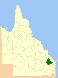
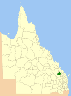
The North Burnett Region is a local government area in Queensland, Australia in the northern catchment of the Burnett River. Established in 2008, it was preceded by several previous local government areas with histories extending back to the early 1900s.

<span class="mw-page-title-main">Mungar Junction to Monto railway line</span> Former railway line in Queensland, Australia

The Mungar Junction to Monto railway line is a 267 kilometre railway in Queensland, Australia. Progressively opened in eleven stages between 1889 and 1928 the line branched from the North Coast line at Mungar Junction a short distance west of Maryborough and followed a westerly route towards Biggenden and Gayndah before turning north via Mundubbera and Eidsvold to Monto. It is also known as the Gayndah Monto Branch Railway.

Byellee to Monto Branch Railway was a branch railway that branched off the Boyne Valley west of Gladstone in Queensland, Australia.The Boyne Valley region was predominantly a dairying region and a railway had little justification. However a branch was justified in 1906 on the basis of large traffic in timber, fuel, limestone and flexing ores. Progressively opened between 1910 and 1931 the line branched from the North Coast line at Byellee a short distance west of Gladstone and struck a south-westerly route via Many Peaks and Mungungo to Monto.

<span class="mw-page-title-main">Degilbo</span> Town in Queensland, Australia

Degilbo is a rural town and locality in the North Burnett Region, Queensland, Australia. In the 2016 census, the locality of Degilbo had a population of 174 people.

<span class="mw-page-title-main">Ideraway</span> Town in Queensland, Australia

Ideraway is a rural town and locality in the North Burnett Region, Queensland, Australia. In the 2016 census, the locality of Ideraway had a population of 38 people.

<span class="mw-page-title-main">Lockyer Creek Railway Bridge (Lockyer)</span> Historic site in Queensland, Australia

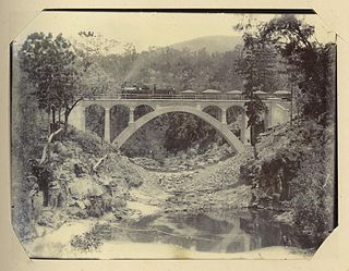
Lockyer Creek Railway Bridge (Lockyer) is a heritage-listed railway bridge on the Toowoomba - Helidon railway line over Lockyer Creek at Lockyer, Lockyer Valley Region, Queensland, Australia. It was designed by William Pagan and built from 1909 to 1910. It was added to the Queensland Heritage Register on 21 October 1992.

<span class="mw-page-title-main">Didcot, Queensland</span> Suburb of North Burnett Region, Queensland, Australia

Didcot is a rural locality in the North Burnett Region, Queensland, Australia. In the 2016 census Didcot had a population of 60 people.

<span class="mw-page-title-main">Deep Creek Railway Bridge</span> Historic site in Queensland, Australia

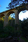
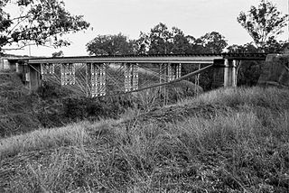
Deep Creek Railway Bridge is a heritage-listed railway bridge on the Mungar-Monto railway line in Didcot, North Burnett Region, Queensland, Australia. It was designed by William Pagan and built in 1905 by day labour. It was added to the Queensland Heritage Register on 21 October 1992.

<span class="mw-page-title-main">William Pagan (railway engineer)</span> Australian railway engineer

William Pagan (1849–1924) was a railway engineer in Queensland, Australia. He designed many railway bridges, some of which are now heritage-listed.

<span class="mw-page-title-main">Ideraway Creek Railway Bridge</span> Historic site in Queensland, Australia

Ideraway Creek Railway Bridge is a heritage-listed railway bridge at Mungar - Monto Line, Ideraway, North Burnett Region, Queensland, Australia. It was designed by William Pagan and built from 1906 to 1907 using day labour. It was added to the Queensland Heritage Register on 21 October 1992.

Humphery is a rural locality in the North Burnett Region, Queensland, Australia. In the 2016 census, Humphery had a population of 34 people.

<span class="mw-page-title-main">Humphery Railway Bridge</span> Historic site in Queensland, Australia

Humphery Railway Bridge is a heritage-listed railway bridge on the Mungar to Monto railway line at Humphery, North Burnett Region, Queensland, Australia. It was designed by William Pagan and built in 1913. It was added to the Queensland Heritage Register on 21 October 1992.

Reids Creek is a rural locality in the North Burnett Region, Queensland, Australia. In the 2016 census Reids Creek had a population of 54 people.

Dirnbir is a rural locality in the North Burnett Region, Queensland, Australia. In the 2016 census, Dirnbir had a population of 49 people.

Mount Lawless is a rural locality in the North Burnett Region, Queensland, Australia. In the 2016 census, Mount Lawless had a population of 12 people.

The Boyne Burnett Inland Rail Trail is a recreational route for walkers, cyclists and horse riders from Taragoola to Gayndah. It uses the closed Gladstone to Monto and Mungar Junction to Monto railway corridors in Queensland, Australia.

References

  1. 1 2 3 4 5 6 7 "Steep Rocky Creek Railway Bridge (Ideraway) (entry 600520)". Queensland Heritage Register . Queensland Heritage Council. Retrieved 1 August 2014.
  2. 1 2 3 "The Gayndah Railway". Maryborough Chronicle, Wide Bay and Burnett Advertiser . No. 10, 324. Queensland, Australia. 26 December 1905. p. 2. Retrieved 23 August 2016 via National Library of Australia.
  3. McLachlan, Mark (6 June 2018). "Degilbo to Mundubbera Railway Bridges, 1905 to 1914". Boyne Burnett Inland Rail Trail. Retrieved 25 September 2022.
  4. McGrath, PSM, B. L.; Churchward, Alan (October 2015). "Nomination of the Gayndah Rail Bridges, Queensland for ENGINEERING HERITAGE RECOGNITION under Engineering Heritage Australia's Engineering Heritage Recognition Program" (PDF). engineersaustralia.org.au/engineering-communities/engineering-heritage-australia. Retrieved 26 September 2022.

Attribution

CC-BY-icon-80x15.png This Wikipedia article was originally based on "The Queensland heritage register" published by the State of Queensland under CC-BY 3.0 AU licence (accessed on 7 July 2014, archived on 8 October 2014). The geo-coordinates were originally computed from the "Queensland heritage register boundaries" published by the State of Queensland under CC-BY 3.0 AU licence (accessed on 5 September 2014, archived on 15 October 2014).

Commons-logo.svg Media related to Steep Rocky Creek Railway Bridge at Wikimedia Commons