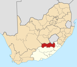
Steynsburg

Last updated

Steynsburg
Steynsburg dorpsbeeld.JPG
View of Steynsburg
South Africa Eastern Cape location map.svg
Red pog.svg
Steynsburg
South Africa adm location map.svg
Red pog.svg
Steynsburg
Coordinates: 31°17′47″S25°49′22″E / 31.29639°S 25.82278°E / -31.29639; 25.82278
Country South Africa
Province Eastern Cape
District Joe Gqabi
Municipality Walter Sisulu
Government
  TypeLocal Municipality
  Councillor(ANC)
Area
[1]
  Total17.4 km2 (6.7 sq mi)
Elevation
1,450 m (4,760 ft)
Population
 (2011) [1]
  Total7,212
  Density410/km2 (1,100/sq mi)
Racial makeup (2011)
[1]
   Black African 80.5%
   Coloured 14.7%
   Indian/Asian 0.2%
   White 3.9%
  Other0.6%
First languages (2011)
[1]
   Xhosa 74.4%
   Afrikaans 20.5%
   English 1.8%
   Sotho 1.0%
  Other2.4%
Time zone UTC+2 (SAST)
Postal code (street)
5920
PO box
5920
Area code 048
The ANC's parliamentary constituency office in Steynsburg ANC parliamentary constituency office in Steynsburg, EC.jpg
The ANC's parliamentary constituency office in Steynsburg

Steynsburg is a small town in the Walter Sisulu Local Municipality of the Joe Gqabi District Municipality, Eastern Cape province of South Africa. Steynsburg is located on the intersection of the R56 and R390.

Contents

The town lies 64 kilometres (40 mi) south-west of Burgersdorp and 48 kilometres (30 mi) north of Hofmeyr. It developed around the Reformed Church established in 1872 and has been administered by a village management board since 1874. Steynsburg is named after Douwe Gerbrandt Steyn, grandfather of President Paul Kruger. [2]

Steynsburg has a well-established Provincial hospital. [3]

Notable citizens

Related Research Articles

<span class="mw-page-title-main">Eastern Cape</span> Province in South Africa

The Eastern Cape is one of the nine provinces of South Africa. Its capital is Bhisho, but its two largest cities are East London and Gqeberha. Due to its climate and nineteenth century towns, it is a common location for tourists. It is also known for being home to many anti-apartheid activists, the most famous being Nelson Mandela hailing from the province.

<span class="mw-page-title-main">Stellenbosch</span> Town in Western Cape, South Africa

Stellenbosch is a town in the Western Cape province of South Africa, situated about 50 kilometres east of Cape Town, along the banks of the Eerste River at the foot of the Stellenbosch Mountain. The town became known as the City of Oaks or Eikestad in Afrikaans and Dutch due to the large number of oak trees that were planted by its founder, Simon van der Stel, to grace the streets and homesteads.

The Netherlands–South African Railway Company or NZASM was a railway company established in 1887. The company was based in Amsterdam and Pretoria, and operated in the South African Republic (ZAR) during the late 19th century. At the request of ZAR president Paul Kruger, the NZASM constructed a railway line between Pretoria and Lourenço Marques in Portuguese East Africa.

The following lists events that happened during 1894 in South Africa.

<span class="mw-page-title-main">R56 (South Africa)</span> Road in South Africa

The R56 is a provincial route in South Africa that connects Middelburg with Pietermaritzburg via Molteno, Maclear and Kokstad. It is co-signed with the N2 between Kokstad and Stafford's Post for 39 kilometres.

<span class="mw-page-title-main">Gansbaai</span> Place in Western Cape, South Africa

Gansbaai is a fishing town and popular tourist destination in the Overberg District Municipality, Western Cape, South Africa. It is known for its dense population of great white sharks and as a whale-watching location.

<span class="mw-page-title-main">Makhanda, South Africa</span> Town in Eastern Cape, South Africa

Makhanda, formerly known as Grahamstown, is a town of about 140,000 people in the Eastern Cape province of South Africa. It is situated about 110 kilometres (70 mi) northeast of Gqeberha and 130 kilometres (80 mi) southwest of East London. It is the largest town in the Makana Local Municipality, and the seat of the municipal council. It also hosts Rhodes University, the Eastern Cape Division of the High Court, the South African Library for the Blind (SALB), a diocese of the Anglican Church of Southern Africa, and 6 South African Infantry Battalion. Furthermore, located approximately 3 km south-east of the town lies the world renowned Waterloo Farm, the only estuarine fossil site in the world from 360 million years ago with exceptional soft-tissue preservation.

<span class="mw-page-title-main">Somerset West</span> Town in the Western Cape, South Africa

Somerset West is a town in the Western Cape, South Africa. Organisationally and administratively it is included in the City of Cape Town metropolitan municipality Eastern Suburbs zone . The vehicle registration code for Somerset West is CFM and the post code is 7130 for street addresses, and 7129 for post office boxes.

<span class="mw-page-title-main">Caledon, South Africa</span> Place in Western Cape, South Africa

Caledon, originally named Swartberg, is a town in the Overberg region in the Western Cape province of South Africa, located about 100 kilometres (62 mi) east of Cape Town next to mineral-rich hot springs. As of 2011 it had a population of 13,020. It is located in, and the seat of, the Theewaterskloof Local Municipality.

<span class="mw-page-title-main">Bredasdorp</span> Place in Western Cape, South Africa

Bredasdorp is a town in the Southern Overberg region of the Western Cape, South Africa, and the main economic and service hub of that region. It lies on the northern edge of the Agulhas Plain, about 160 kilometres (100 mi) south-east of Cape Town and 35 kilometres (22 mi) north of Cape Agulhas, the southernmost tip of Africa.

Whittlesea is a semi-rural town situated on the R67 road in the Hewu district, 37 km south of Komani, Eastern Cape Province, South Africa. The town is made up of the townships Ekuphumleni, Bhede, Ndlambe, Extension 4, Extension 5 and Sada. The town falls under the Enoch Mgijima Local Municipality which is under the Chris Hani District Municipality. Surrounding Whittlesea are 36 villages which make up the Hewu district.

<span class="mw-page-title-main">Cookhouse, South Africa</span> Place in Eastern Cape, South Africa

Cookhouse is a small village located in Eastern Cape province, South Africa, some 170 kilometres (110 mi) north of Port Elizabeth and 24 kilometres (15 mi) east of Somerset East, on the west bank of the Great Fish River.

<span class="mw-page-title-main">Burgersdorp</span> Place in Eastern Cape, South Africa

Burgersdorp is a medium-sized town in Walter Sisulu in the Joe Gqabi District Municipality of the Eastern Cape province of South Africa.

<span class="mw-page-title-main">Vanrhynsdorp</span> Place in Western Cape, South Africa

Vanrhynsdorp is a town located in the West Coast District Municipality of the Western Cape province in South Africa. Considered the oldest and most southern European-settled town in Namaqualand, Vanrhynsdorp serves as a gateway to the Succulent Karoo and Nama Karoo regions to the north and east.

Enon is a small town in the Eastern Cape in South Africa. It is named after the biblical place mentioned in John 3:23 It lies 13 kilometres (8.1 mi) east of Kirkwood and 60 kilometres (37 mi) north-east of Uitenhage.

<span class="mw-page-title-main">Pearston</span> Place in Eastern Cape, South Africa

Pearston is a small town in the eastern Karoo, in the Eastern Cape province of South Africa. It lies between Graaff-Reinet and Somerset East at the foot of the Coetzeesberge, about 160 kilometres (100 mi) north of Port Elizabeth. It falls within the Blue Crane Route Local Municipality and has a population of approximately 4,500 people.

<span class="mw-page-title-main">Sterkstroom</span> Place in Eastern Cape, South Africa

Sterkstroom is a settlement in Enoch Mgijima Local Municipality of the Chris Hani District in the Eastern Cape province of South Africa.

Steynsdorp, officially eMlondozi, is a settlement in Gert Sibande District Municipality in the Mpumalanga province of South Africa.

Komga is a town in Amatole District Municipality in the Eastern Cape province of South Africa.

References

  1. 1 2 3 4 Sum of the Main Places Khayamnandi and Steynsburg from Census 2011.
  2. "Dictionary of Southern African Place Names (Public Domain)". Human Science Research Council. p. 417.
  3. Eastern Cape Department of Health website

Commons-logo.svg Media related to Steynsburg at Wikimedia Commons