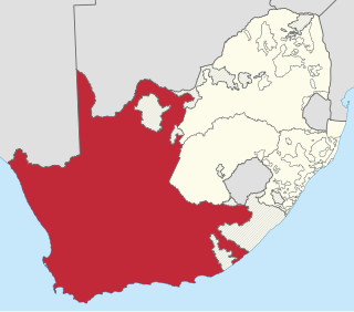
The Province of the Cape of Good Hope, commonly referred to as the Cape Province and colloquially as The Cape, was a province in the Union of South Africa and subsequently the Republic of South Africa. It encompassed the old Cape Colony, as well as Walvis Bay, and had Cape Town as its capital. In 1994, the Cape Province was divided into the new Eastern Cape, Northern Cape and Western Cape provinces, along with part of the North West.

Peterhead is a town in Aberdeenshire, Scotland. It is Aberdeenshire's biggest settlement, with a population of 18,537 at the 2011 Census. It is the biggest fishing port in the United Kingdom for total landings by UK vessels, according to a 2019 survey.

The River Ugie or Ugie Water is a river in North East Scotland; it flows into the North Sea on the east coast at Peterhead, north of Cruden Bay. There is considerable evidence of prehistoric settlement within the Ugie drainage basin, especially in the South Ugie Water catchment basin. For example, the Catto Long Barrow is found somewhat to the south of the Ugie Water mainstem.

Kalk Bay is a fishing village on the coast of False Bay, South Africa and is now a suburb of greater Cape Town. It lies between the ocean and sharply rising mountainous heights that are buttressed by crags of grey Table Mountain Sandstone. The railway from Cape Town to Simon's Town passes through Kalk Bay and in some places the line is only metres from the water's edge.
Ugie or UGIE may refer to:
The South Ugie Water is a tributary of the Ugie Water in northeastern Aberdeenshire, Scotland. To the south of the Ugie Water are a number of prehistoric monuments, evidencing the habitation of early man in the northeast of Scotland; for example, the Catto Long Barrow and a number of tumuli are situated in this locale.

Ladismith is a town and agricultural centre in the western Little Karoo region of South Africa's Western Cape province.

Prieska is a town on the south bank of the Orange River, in the province of the Northern Cape, in western South Africa. It is located on the southern bank of the Orange River, 130 km north-west of Britstown and 75 km south-east of Marydale.
Bothasig is a suburban area of the City of Cape Town in Western Cape, South Africa. It is located north of Edgemead and east of Milnerton. It is located approximately 15 km north-east of the Cape Town city centre.
Maclear is a small town situated in the Eastern Cape province of South Africa, near the Mooi River, 172 km (107 mi) north of East London and 80 km (50 mi) northeast of Elliot. It was founded in 1876 as a military camp, called Nqanqaru Drift and developed rapidly, reaching municipal status in 1916. It is named after Sir Thomas Maclear (1794-1879), a famous astronomer who laid the foundation for a trigonometrical survey of the Cape Colony.
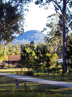
Glenugie Peak, also known as Mount Elaine or as Glen Ugie Peak, a mountain that is part of the ridge surrounding the Clarence Moreton Basin, is situated in the Northern Rivers region of New South Wales, Australia. At an elevation of 316 metres (1,037 ft) above sea level, the mountain is located near the Pacific Highway, south of the town of Grafton and approximately 6 kilometres (3.7 mi) west north-west of the locality of Calamia.

Utkalmani Gopabandhu Institute of Engineering (UGIE) is a State Governmental Diploma Engineering Institution in the western Zone of Odisha, which was established in 1962 under the Directorate of Technical Education and Training, Odisha also known as DTET.

Mamre is a small rural town in the Western Cape province of South Africa. It is situated on the northernmost border of the City of Cape Town Metropolitan Municipality. It is situated approximately 55 kilometres (30 mi) north of central Cape Town, and 5–6 km to the neighbouring industrial town of Atlantis.
The Tsitsa River is a river in the Eastern Cape Province, South Africa. It is a tributary of the Mzimvubu River and belongs to the Mzimvubu to Keiskamma Water Management Area.

Thamnocalamus tessellatus is a species of bamboo belonging to the family Poaceae, and native to the high mountains of South Africa, Lesotho and Eswatini, lying along the south-eastern part of South Africa. It is found in the Amatola Mountains, the Bamboesberg, which is named for it, and the Drakensberg. Its generic name means "bushy reed", while the specific name means "tiled", an allusion to the rectangular pattern of veins on the leaves. Its common names include Mountain Bamboo, and Bergbamboes and Wildebamboes in Afrikaans.

Strandfontein is a seaside resort 8 km east of Muizenberg and just west of Michells Plain, on the northern shore of False Bay in the City of Cape Town municipality in the Western Cape province of South Africa.

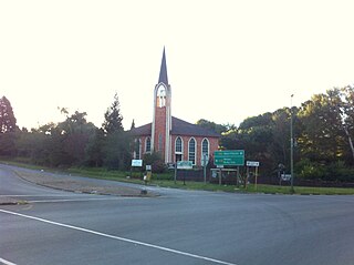
Prentjiesberg is an outlier mountain of the Drakensberg in the Eastern Cape Province of South Africa, at about 2000 m above sea level and some 10 km north-west of the town of Ugie, near the southern tip of the mountain kingdom of Lesotho. The mountain stands high above the surrounding countryside, has a small summit area, with steep slopes and a local relief of 300 m or more.

John Knox Bokwe was a South African journalist, Presbyterian minister and one of the most celebrated Xhosa hymn writers and musician. He is best known for his compositions Vuka Deborah, Plea for Africa, and Marriage Song.
Maj. Sir Henry George Elliot, was a Canadian-born soldier and administrator, and Chief Magistrate of the Tembuland territories in South Africa from 1891 to 1902. He was a son of Maj. J. F. Elliot.

Peterhead Golf Club, in Peterhead, Aberdeenshire, Scotland, was founded in 1841, making it, by its own claim, the 18th-oldest golf club in the world. Located on the River Ugie near its mouth with the North Sea, it began in its current Craigewan Links home, which is just over a mile northwest of Peterhead town centre, as a nine-hole course in 1892, designed by dual winner of The Open Championship Willie Park, Jr. Known colloquially as the "Old Course", it was extended to eighteen holes in 1908. A second eighteen-hole course was established in 1923; however, due to the intervention of World War II, it became neglected about twenty years later and today exists as the nine-hole "New Course".


