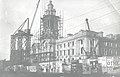
Stockport Town Hall

Last updated

Stockport Town Hall
Stockport Town Hall.jpg
Stockport Town Hall
Stockport Town Hall
General information
Architectural style English Baroque style
Classification
Listed Building – Grade II*
Designated10 March 1975
Reference no. 1067166
Town or city Stockport, Greater Manchester
CountryUnited Kingdom
Coordinates 53°24′21″N2°9′31″W / 53.40583°N 2.15861°W / 53.40583; -2.15861
Inaugurated1908
Owner Stockport Metropolitan Borough Council
Height40 m (130 ft)
Design and construction
Architect(s) Sir Alfred Brumwell Thomas

Stockport Town Hall is a building in Stockport, Greater Manchester, England, that houses the government and administrative functions of Stockport Metropolitan Borough Council. Stockport Town Hall is a Grade II* listed building. [1]

Contents

History

The building, which was designed by the architect Sir Alfred Brumwell Thomas in the English Baroque style, was opened by the then Prince and Princess of Wales on 7 July 1908. [1] To commemorate the Royal visit, part of Heaton Lane, a main shopping street in the town, was renamed Prince's Street. [2] [3] [4]

The ballroom in the town hall served as a hospital during the First World War and was used as a home for refugees from the Channel Islands during the Second World War. [5]

The town hall, which had served as the headquarters of the county borough of Stockport for much of the 20th century, continued to be the local seat of government after the enlarged Stockport Metropolitan Borough Council was formed in 1974. [6]

Description

The chamber is decorated with elaborate plasterwork, brass chandeliers and decorative carvings on oak benches. [7] The civic collection of silver, some of which dates from the 15th century, lines the wall of the corridor outside the chamber. [7]

An imposing Italian marble entrance leads to the Edwardian Ballroom, which former poet laureate Sir John Betjeman described as "magnificent". [8]

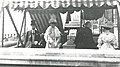
The ballroom has a Wurlitzer Publix One theatre organ with four manuals and 20 ranks of pipes, specified by Jesse Crawford. [9] It was originally installed in the Paramount Cinema on Oxford Road in Manchester in 1930; it had been planned to install one of these in each of the 50 Paramount theatres, however this was the only one to be installed, and the only one of that model to leave the United States. When the theatre was divided, the organ was acquired by the Lancastrian Theatre Organ Trust, loaned to the city of Manchester and relocated to the Free Trade Hall (a process taking four years); and was first used there in September 1977. When the Free Trade Hall closed, it was moved to Stockport Town Hall in 1999. [10] [11]

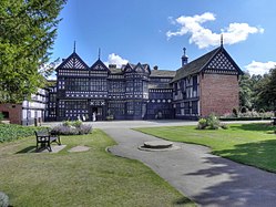
The town hall, which as the home of Stockport Symphony Orchestra, hosts classical concerts on a regular basis, [12] has been nicknamed "the wedding cake". [4]

See also

Related Research Articles

<span class="mw-page-title-main">Greater Manchester</span> County of England

Greater Manchester is a ceremonial county in North West England. It borders Lancashire to the north, Derbyshire and West Yorkshire to the east, Cheshire to the south, and Merseyside to the west. Its largest settlement is the city of Manchester.

<span class="mw-page-title-main">Tameside</span> Borough in Greater Manchester, England

Tameside is a metropolitan borough of Greater Manchester, England, named after the River Tame, which flows through it, and includes the towns of Ashton-under-Lyne, Audenshaw, Denton, Droylsden, Dukinfield, Hyde, Mossley and Stalybridge. Tameside is bordered by the metropolitan boroughs of Stockport to the south, Oldham to the north and northeast, Manchester to the west, and to the east by the Borough of High Peak in Derbyshire. As of 2021, the population of Tameside was 231,199, making it the 8th-most populous borough of Greater Manchester by population.

<span class="mw-page-title-main">Stockport</span> Town in Greater Manchester, England

Stockport is an industrial town in Greater Manchester, England, 7 miles (11 km) south-east of Manchester, 9 miles (14 km) south-west of Ashton-under-Lyne and 12 miles (19 km) north of Macclesfield. The River Goyt and Tame merge to create the River Mersey here. It is the main settlement of the wider Metropolitan Borough of Stockport.

<span class="mw-page-title-main">High Peak, Derbyshire</span> Local government district in Derbyshire, England

High Peak is a local government district with borough status in Derbyshire, England, covering a high moorland plateau in the Dark Peak area of the Peak District National Park. The district stretches from Holme Moss in the north to Sterndale Moor in the south, and from Hague Bar in the west to Bamford in the east. The population of the borough taken at the 2011 Census was 90,892. The borough is unusual in having two administrative centres for its council, High Peak Borough Council; the offices are in Buxton and Glossop. Other towns include Chapel-en-le-Frith, Hadfield, New Mills and Whaley Bridge.

<span class="mw-page-title-main">Free Trade Hall</span> Historic building in Manchester, England

The Free Trade Hall on Peter Street, Manchester, England, was constructed in 1853–56 on St Peter's Fields, the site of the Peterloo Massacre. It is now a Radisson hotel.

<span class="mw-page-title-main">Wilmslow Road</span> Major road in Manchester, England

Wilmslow Road is a major road in Manchester, England, running from Parrs Wood northwards to Rusholme. There it becomes Oxford Road and the name changes again to Oxford Street when it crosses the River Medlock and reaches the city centre.

<span class="mw-page-title-main">Bramhall</span> Human settlement in England

Bramhall is an area in the Metropolitan Borough of Stockport, Greater Manchester, England. Historically in Cheshire, it had a population of 17,436 at the 2011 Census.

<span class="mw-page-title-main">Cheadle Hulme</span> Suburb of Stockport, Greater Manchester, England

Cheadle Hulme is a suburb in the Metropolitan Borough of Stockport, Greater Manchester, England,. Historically in Cheshire, it is 2 miles (3.2 km) south-west of Stockport and 8 miles (12.9 km) south-east of Manchester. It lies in the Ladybrook Valley, on the Cheshire Plain, and the drift consists mostly of boulder clay, sands and gravels. In 2011, it had a population of 26,479.

<span class="mw-page-title-main">Marple, Greater Manchester</span> Town in Greater Manchester, England

Marple is a town in the Metropolitan Borough of Stockport, Greater Manchester, England. It is on the River Goyt, 9 miles (14 km) south-east of Manchester, 9 miles (14 km) north of Macclesfield and 4 miles (6 km) south-east of Stockport. In 2011, it had a population of 23,686.

<span class="mw-page-title-main">High Lane, Greater Manchester</span> Human settlement in England

High Lane is a village in the Metropolitan Borough of Stockport, Greater Manchester, England, on the Macclesfield Canal, 5 miles (8 km) from Stockport.

<span class="mw-page-title-main">Cheadle, Greater Manchester</span> Village in Greater Manchester, England

Cheadle is a village in the Metropolitan Borough of Stockport, Greater Manchester, England. Within the boundaries of the historic county of Cheshire, it borders Cheadle Hulme, Gatley, Heald Green and Cheadle Heath in Stockport, and East Didsbury in Manchester. In 2011, it had a population of 14,698.

<span class="mw-page-title-main">Metropolitan Borough of Stockport</span> Borough of Greater Manchester, England

The Metropolitan Borough of Stockport is a metropolitan borough of Greater Manchester in England. It is south-east of central Manchester and south of Tameside. As well as the towns of Stockport, Bredbury and Marple, it includes the outlying villages and suburbs of Hazel Grove, Bramhall, Cheadle, Cheadle Hulme, Gatley, Reddish, Woodley and Romiley. In 2021, it had a population of 295,243, making it the fourth-most populous borough of Greater Manchester.

<span class="mw-page-title-main">Marple Bridge</span> Human settlement in England

Marple Bridge is a district of Marple in the Metropolitan Borough of Stockport, Greater Manchester, England, on the River Goyt, which runs through the centre of the village.

<span class="mw-page-title-main">County Borough of Stockport</span> Former municipal borough in present-day town of Stockport

Stockport County Borough was a county-level local authority between 1889 and 1974.

<span class="mw-page-title-main">Staircase House</span> Medieval building and museum in Stockport, England

Staircase House, also known as Stockport Museum, is a Grade II* listed medieval building dating from around 1460 situated in Stockport, historically in Cheshire, now within Greater Manchester, England. The house is famous for its rare Jacobean cage newel staircase. An audio guide recounts the full history of the house.

<span class="mw-page-title-main">Abney Hall</span> Building in Greater Manchester, England

Abney Hall is a Victorian house surrounded by a park in Cheadle, Greater Manchester, England, built in 1847. It is a Grade II* listed building.

<span class="mw-page-title-main">St Thomas' Church, Stockport</span> Church in Greater Manchester, England

St Thomas' Church is in St Thomas's Place, Wellington Road South, Stockport, Greater Manchester, England. It is an active Church of England church in the parish of Stockport and Brinnington, in the deanery of Stockport, the archdeaconry of Macclesfield, and the diocese of Chester. The church is recorded in the National Heritage List for England as a designated Grade I listed building. It was a Commissioners' church, having received a grant towards its construction from the Church Building Commission.

<span class="mw-page-title-main">Underbank Hall</span> 16th-century town house in Stockport, England

Underbank Hall is a 16th-century town house in the centre of Stockport, Greater Manchester, England. The hall dates back to the 15th century and became a Grade II listed building on 20 July 1986. It was the home of a branch of the Arden family of Bredbury, who were related to William Shakespeare on his mother's side.

<span class="mw-page-title-main">Grade I listed buildings in Greater Manchester</span>

There are 48 Grade I listed buildings in Greater Manchester, England. In the United Kingdom, the term listed building refers to a building or other structure officially designated as being of special architectural, historical or cultural significance; Grade I structures are those considered to be "buildings of exceptional interest". In England, the authority for listing under the Planning Act 1990 rests with Historic England, a non-departmental public body sponsored by the Department for Culture, Media and Sport.

<span class="mw-page-title-main">Odeon Cinema, Manchester</span> Cinema in Manchester, England

The Odeon Cinema, Manchester was a former Odeon Cinema located on Oxford Street, Manchester, England. It was close to St. Peter's Square, within the Civic Quarter of Manchester city centre. It was demolished in April 2017, and replaced by Landmark, a 14-storey office building, as part of a major transformation of the area.

References

  1. 1 2 Historic England. "Town Hall (1067166)". National Heritage List for England . Retrieved 9 May 2016.
  2. Arrowsmith, Peter (1997). Stockport: a History. Stockport: Stockport Metropolitan Borough Council. p. 246. ISBN   0-905164-99-7.
  3. Pevsner, Nikolaus (1971). The Buildings of England: Cheshire. London: Penguin. p. 341. ISBN   0-14-071042-6.
  4. 1 2 "Town Hall (2005)". Stockport Metropolitan Borough Council. Archived from the original on 28 September 2011. Retrieved 14 April 2014.
  5. "Stockport Town Hall celebrates centenary". Cheshire Life. 14 January 2010. Retrieved 9 August 2020.
  6. Local Government Act 1972. 1972 c.70. The Stationery Office Ltd. 1997. ISBN   0-10-547072-4.
  7. 1 2 Littlechilds, Ian; Page, Phil (2017). Secret Stockport. Amberley Publishing. ISBN   978-1445651361.
  8. "Stockport Town Hall". Archiseek. Retrieved 11 April 2020.
  9. "Stockport Town Hall". Cinema Organs. Retrieved 9 August 2020.
  10. "Stockport". Lancastrian Theatre Organ Trust. Retrieved 9 August 2020.
  11. "About Lancastrian Theatre Organ Trust - Stockport". Organfx. Retrieved 11 April 2020.
  12. "Stockport Symphony Orchestra". Stockport Metropolitan Borough Council. Retrieved 11 April 2020.

53°24′21″N2°9′31″W / 53.40583°N 2.15861°W / 53.40583; -2.15861