Sleaford is a market town and civil parish in the North Kesteven district of Lincolnshire, England. Centred on the former parish of New Sleaford, the modern boundaries and urban area include Quarrington to the south-west, Holdingham to the north and Old Sleaford to the east. The town is on the edge of the fertile Fenlands, 11 miles north-east of Grantham, 16 mi (26 km) west of Boston, and 17 mi (27 km) south of Lincoln. Its population of 17,671 at the 2011 Census made it the largest settlement in the North Kesteven district; it is the district's administrative centre. Bypassed by the A17 and the A15, it is linked to Lincoln, Newark, Peterborough, Grantham and King's Lynn.
Lincolnshire, England derived from the merging of the territory of the ancient Kingdom of Lindsey with that controlled by the Danelaw borough Stamford. For some time the entire county was called 'Lindsey', and it is recorded as such in the Domesday Book. Later, Lindsey was applied to only the northern core, around Lincoln; it was defined as one of the three 'Parts of Lincolnshire', along with Holland in the south-east and Kesteven in the south west.

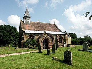
Nocton is a village and civil parish in the North Kesteven district of Lincolnshire, England. It is situated on the B1202 road, 7 miles (11 km) south-east from Lincoln city centre. The population of the civil parish at the 2011 census was 819. To the east of the village is Nocton Fen with its small settlement of Wasps Nest. To the west of the village, situated at the junction of Wellhead Lane and the B1188 road, is Nocton Top Cottages consisting of eight further dwellings. At the south of the village are the remains of Nocton Hall, and 1 mile (2 km) to the east the earthwork remains of Nocton Park Priory.

Stow is a village and civil parish within the West Lindsey district of Lincolnshire, England. It is 11 miles (18 km) north-west of the city of Lincoln and 6 miles (10 km) south-east of Gainsborough, and lies along the B1241 road. The total resident population was 355 at the 2001 census, increasing to 365 at the 2011 census.

Threekingham is a village in the North Kesteven district of Lincolnshire, England. The population of the civil parish at the 2011 census was 233. It is situated on the A52 Grantham to Boston road, 6 miles (10 km) south from Sleaford, and close to the A15 Threekingham Bar roundabout. Mareham Lane, the Roman Road aligned with King Street, crosses the A15 at Threekingham.
Dowsby is a village and civil parish in the South Kesteven district of Lincolnshire, England. It is situated on the western edge of The Fens at the junction of the east–west B1397 road and the north–south B1177. It is 1 mile (1.6 km) north-east from Rippingale and just south of Pointon. The civil parish includes the hamlet of Graby. Nearby to the east, along the B1397 at Dowsby Fen, is Car Dyke. The civil parish population taken at the 2011 census was 204.

Billingborough is a village and civil parish in the South Kesteven district of Lincolnshire, England. It is situated approximately 10 miles (16 km) north of Bourne and 10 miles south of Sleaford, and on the B1177 between Horbling and Pointon just south of the A52.
Brothertoft is a village in Lincolnshire, England, about 4 miles (6.4 km) northwest from the market town of Boston. It is part of the civil parish of Holland Fen with Brothertoft.
Heckington is a village and civil parish in the North Kesteven district of Lincolnshire, England. It is situated between Sleaford and Swineshead Bridge, and south of the A17 road. Heckington, with 1,491 households, is one of the largest villages in Lincolnshire.. The population of the civil parish including Boughton was 3,353 at the 2011 census.

Mareham le Fen is a village and civil parish about 6 miles (10 km) south from the town of Horncastle, Lincolnshire, England. The hamlet of Mareham Gate lies about 0.5 miles (0.8 km) south from the village, and it is believed that the deserted medieval village (DMV) of Birkwood is situated nearby.

Burton Pedwardine is a hamlet and civil parish in the district of North Kesteven, Lincolnshire, England. The population at the 2011 census was 187. The hamlet is situated approximately 4 miles (6 km) south-east from the market town of Sleaford and south-west of the village of Heckington.

Horbling is a village and civil parish in the South Kesteven district of Lincolnshire, England. It lies on the B1177, 7 miles (11 km) south-east of Sleaford, 14.5 miles (23 km) north-east of Grantham and 0.5 miles (0.8 km) north of Billingborough.

Folkingham is an English village and civil parish on the northern edge of the South Kesteven district of Lincolnshire. The civil and ecclesiastical parishes cover the same area. Folkingham lies on the A15 road 11 miles (18 km) north of Bourne and 10 miles (16 km) south of Sleaford. The 2001 Census gave a population of 729, rising to 796 at the 2011 census, and estimated at 795 in 1919.

Quarrington is a village and former civil parish, now part of the civil parish of Sleaford, in the North Kesteven district of Lincolnshire, a non-metropolitan county in the East Midlands of England. The old village and its church lie approximately 1.2 miles (2 km) south-west from the centre of Sleaford, the nearest market town, but suburban housing developments at New Quarrington and Quarrington Hill effectively link the two settlements. Bypassed by the A15, it is connected to Lincoln and Peterborough, as well as Newark and King's Lynn. At the 2011 census, Quarrington and Mareham ward, which incorporates most of the settlement, had an estimated population of 7,046.
Mareham Lane is an unclassified road between Graby and Sleaford in Lincolnshire, England. It is approximately 10.6 miles (17.1 km) long.
Claxby Pluckacre is a hamlet in the East Lindsey district of Lincolnshire, England. It is situated approximately 5 miles (8.0 km) south-east from the town of Horncastle. It is in the civil parish of Wood Enderby.
Hameringham is an extended village in the East Lindsey district of Lincolnshire, England. It is situated 4 miles (6.4 km) south-east from the town of Horncastle, and consists of High Hameringham and Low Hammeringham. It is in the civil parish of Lusby with Winceby.
Ewerby and Evedon is a civil Parish in North Kesteven, Lincolnshire, England. It includes the villages of Ewerby and Evedon, the hamlet of Haverholme, and is situated immediately west of Sleaford. The population of the civil parish at the 2011 census was 509.
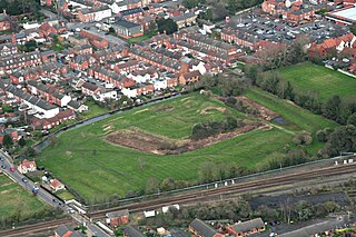
Mareham Pastures is an 11-hectare Local Nature Reserve in Sleaford, a market town and civil parish in the North Kesteven district of Lincolnshire. It is owned by Lincolnshire County Council and managed jointly by Lincolnshire County Council and the Friends of Mareham Pastures. The reserve consists of wildflower meadows, new woodland, hedges and open grassland, providing a good habitat for butterflies and potentially barn owls; it is located westwards off Mareham Lane and is bounded to the north and north-west by residential developments at Quarrington and by farmland to the south; it is adjacent to a disused recycling centre, situated to its east. The site can be accessed by the public on foot via Bullock Pastures Lane, which begins at Sleaford Cricket Ground off London Road; visitors travelling by car can park next to the former recycling centre off Mareham Lane and gain access that way.

