
Dartmouth is a town and civil parish in the English county of Devon. It is a tourist destination set on the western bank of the estuary of the River Dart, which is a long narrow tidal ria that runs inland as far as Totnes. It lies within the South Devon Area of Outstanding Natural Beauty and South Hams district, and had a population of 5,512 in 2001, reducing to 5,064 at the 2011 census. There are two electoral wards in the Dartmouth area. Their combined population at the above census was 6,822.

The London Borough of Bexley is a London borough in south-east London, forming part of Outer London. It has a population of 248,287. The main settlements are Sidcup, Erith, Bexleyheath, Crayford, Welling and Old Bexley. The London Borough of Bexley is within the Thames Gateway, an area designated as a national priority for urban regeneration. The local authority is Bexley London Borough Council.

North Toronto is a former town and informal district located in the northern part of the Old Toronto district in Toronto, Ontario, Canada. Currently occupying a geographically central location within the city of Toronto, the Town of North Toronto was incorporated in 1890, when much of the area was still farmland, and annexed by the old city of Toronto in 1912. The name is still used to refer to the area in general, although Yonge–Eglinton and Midtown Toronto are officially used.
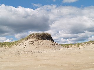
Plum Island is a barrier island located off the northeast coast of Massachusetts, north of Cape Ann, in the United States. It is approximately 11 miles (18 km) in length. The island is named for the wild beach plum shrubs that grow on its dunes, but is also famous for the purple sands at high tide, which get their color from tiny crystals of pink pyrope garnet. It is located in parts of four municipalities in Essex County. From north to south they are the city of Newburyport, and the towns of Newbury, Rowley, and Ipswich.

The Long Path is a 357-mile (575 km) long-distance hiking trail beginning in New York City, at the West 175th Street subway station near the George Washington Bridge and ending at Altamont, New York, in the Albany area. While not yet a continuous trail, relying on road walks in some areas, it nevertheless takes in many of the popular hiking attractions west of the Hudson River, such as the New Jersey Palisades, Harriman State Park, the Shawangunk Ridge and the Catskill Mountains. It offers hikers a diversity of environments to pass through, from suburbia and sea-level salt marshes along the Hudson to wilderness and boreal forest on Catskill summits 4,000 feet (1,220 m) in elevation.
The London Borough of Bexley owns and maintains over 100 parks and open spaces within its boundaries, with a total of 638 hectares. They include small gardens, river and woodland areas, and large parks with many sporting and other facilities.

The Southern Suburbs are a group of suburbs in Cape Town, Western Cape, South Africa. This group includes, among others, Observatory, Mowbray, Pinelands, Thornton, Rosebank, Rondebosch, Rondebosch East, Newlands, Claremont, Lansdowne, Kenilworth, Bishopscourt, Constantia, Wynberg, Ottery, Plumstead, Diep River, Bergvliet and Tokai.

Leagrave is a former village and now a suburb of Luton, in the Luton district, in the ceremonial county of Bedfordshire, England, in the northwest of the town. The area is roughly bounded by Vincent Road, Torquay Drive and High Street to the north, Roman Road and Stoneygate Road to the south, the M1 to the west, and Marsh Road and Leagrave Park to the east.

The Cape Cod Rail Trail (CCRT) is a 25.5-mile (41.0 km) paved rail trail located on Cape Cod in Massachusetts. The trail route passes through the towns of Yarmouth, Dennis, Harwich, Brewster, Orleans, Eastham, and Wellfleet. It connects to the 6-plus mile (10 km) Old Colony Rail Trail leading to Chatham, the 2 mile Yarmouth multi-use trail, and 8 miles (13 km) of trails within Nickerson State Park. Short side trips on roads lead to national seashore beaches including Coast Guard Beach at the end of the Nauset Bike Trail in Cape Cod National Seashore. The trail is part of the Claire Saltonstall Bikeway.
A street suffix is the part of a street or road name that describes what type of road it is. Examples include "street", "avenue", "lane", "highway", and "drive". As they are commonly repeated between roads, they are often abbreviated; for example, "St." instead of "Street". The way street suffixes are used varies around the world.

Mytoi is a small Japanese garden set within an open pine forest on Chappaquiddick Island, in Martha's Vineyard, Massachusetts. The Trustees of Reservations owns and maintains the property.

National Cycle Route 1 is a route of the National Cycle Network, running from Dover to Tain. The 1,022 km-long (635-mile) cycle-path is located in the United Kingdom.

The Lea Valley Walk is a 50-mile (80 km) long-distance path located between Leagrave, the source of the River Lea near Luton, and the Thames, at Limehouse Basin, Limehouse, east London. From its source much of the walk is rural. At Hertford the path follows the towpath of the River Lee Navigation, and it becomes increasingly urbanised as it approaches London. The walk was opened in 1993 and is waymarked throughout using a swan logo.

National Cycle Route 57 is part of the United Kingdom's National Cycle Network. When complete, it will run west to east from Farmington, Gloucestershire near Northleach to Welwyn Garden City in Hertfordshire.
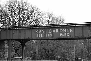
The Beltline Trail is a 9-kilometre (5.6 mi)-long cycling and walking rail trail in Toronto, Ontario, Canada. It consists of three sections, the York Beltline Trail west of Allen Road, the Kay Gardner Beltline Park from the Allen to Mount Pleasant Road, and the Ravine Beltline Trail south of Mount Pleasant Cemetery through the Moore Park Ravine. Built on the former right-of-way of the Toronto Belt Line Railway, the linear park passes through the neighbourhoods of Rosedale, Moore Park, Forest Hill, Chaplin Estates, and Fairbank.
