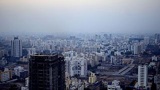
Pune, previously spelled in English as Poona, is a city in the state of Maharashtra in the Deccan plateau in Western India. It is the administrative headquarters of the Pune district, and of Pune division. According to the 2011 Census of India, Pune has 7.2 million residents in the metropolitan region, making it the seventh-most populous metropolitan area in India. The city of Pune is part of Pune Metropolitan Region. Pune is one of the largest IT hubs in India. It is also one of the most important automobile and manufacturing hubs of India. Pune is often referred to as the "Oxford of the East" because of its educational institutions. It has been ranked "the most liveable city in India" several times.

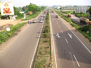
Lonavala-Khandala is a hill station and a Municipal Council in the Pune district, Maharashtra, India. It is about 64 km west of Pune and 96 km to the east of Mumbai. It is known for its production of the hard candy chikki and is also a major stop on the railway line connecting Mumbai and Pune. From the Pune suburbs, local trains are available from Pune Junction. The Mumbai-Pune Expressway and the Mumbai-Bengaluru highway both pass through Lonavala.

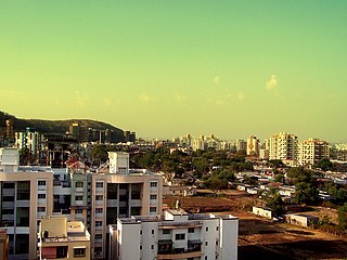
Pimpri-Chinchwad, also known as PCMC, is a city in the Indian state of Maharashtra. The city is about 15 km (9.3 mi) northwest of the historic city of Pune, at an altitude of 590 m (1,940 ft) above sea level. It is the fifth largest city in Maharashtra and the eighteenth largest city in India and the sixteenth largest satellite city in the world by population. The city is located 135 km (84 mi) southeast from the state's capital Mumbai. It is one of the most rapidly developing suburban areas in India and has emerged as the third fastest growing city in the country. It is well known for its automotive, IT and manufacturing industry.
Baramati ([Baramati]) is a city, a tehsil and a municipal council in Pune district in the state of Maharashtra, India. The city is about 100 km southeast of the city of Pune and about 250 km from Mumbai.

Kothrud is an upmarket residential neighborhood in the city of Pune.
Pashan is suburb of Pune, India. It is located off the Mumbai-Bangalore national highway, by-passing Pune city. Pashan road serves as the main approach road for Mumbai-Pune expressway. Pashan is bordered by Baner in north, Sus on west, Bavdhan in south and Pune University in east. It was majorly developed by the D R Kulhalli Company. Pashan is mostly a residential suburb of Pune and large portions are occupied by various governmental and educational institutions. In October 2019, Pashan received more rainfall than the wettest place on Earth.

Hinjawadi is a suburb in Pune, India. It houses the Rajiv Gandhi Infotech Park, a large tech and business park spread over 2,800 acres, which was built by the Maharashtra Industrial Development Corporation. The business park has offices of over 800 companies.

The Hope Foundation and Research Centre - International Institute of Information Technology, Pune (I2IT, pronounced as I Square IT, Pune), is a private institute located at Rajiv Gandhi Infotech Park, Hinjawadi, in Pune, Maharashtra, India. The institute is affiliated to Savitribai Phule Pune University formerly known as University of Pune and is approved by All India Council for Technical Education (AICTE), New Delhi, and is recognized by Directorate of Technical Education (DTE), Govt. of Maharashtra (Institute code – 6754). The institute offers four-year degree program in engineering in three domains: computer science, information technology, and electronics & telecommunication.

Shivajinagar is an inner suburb of the city of Pune, India.
Sarita Vihar is a residential colony situated in South East Delhi, National Capital Territory of Delhi, India. It is near the Kalindi Kunj- Noida Toll bridge or GD Birla Marg-Road 13A which connects the district to Noida.The area is situated close to Uttar pradesh border. It is believed that the site was primarily chosen as the construction site for the Games Village of the 1982 Asian Games, however on the insistence of the late Prime Minister Rajiv Gandhi, the plan was changed to convert it into an upscale residential housing locality. In 2013, it was awarded the "Greenest Colony in Delhi" tag by the then Chief Minister of Delhi Sheila Dikshit, credited to the efforts of its RWA members who have aggressively worked towards improving the state of parks and green spots in the locality.

Pimple Saudagar is a neighbourhood in the city of Pune under Pimpri-Chinchwad Municipal Corporation (PCMC), India. Situated 6 kilometres (3.7 mi) from Chinchwad and close to prominent suburbs of Baner, Wakad, and Aundh, the locality is a progressive residential area that attracts the newer population of the city.
Wakad is a neighbourhood in the city of Pimpri-Chinchwad, India. Given its close proximity to Rajiv Gandhi Infotech Park in Hinjawadi, Wakad has recently emerged to be a popular neighbourhood for techies and experts. It is very diverse and cosmopolitan.
Rahatani is a suburb of Pimpri-Chinchwad situated on the banks of the Pavana in Pune district. Rahatani is 7 kilometres (4.3 mi) from Hinjawadi and centered in between the suburbs of Pimple Saudagar and Kalewadi.
Blue Ridge is a township built under the new Township Act by Paranjape Schemes. Such townships are also known as Integrated Townships. It is located in Hinjawadi in Pimpri Chinchwad, Maharashtra, India. The township area is approximately 138 acres and was designed to be a self sufficient town with various amenities available inside the town. Citizens started occupying the houses since 2010, and continues to develop itself with newer mid- and high-rise residential towers.

Bhoirwadi is an area located in Hinjawadi Phase-3, Pune, in the state of Maharashtra, India. It is under the jurisdiction of Hinjawadi and Pune Metropolitan Region Development Authority (PMRDA). The Rajiv Gandhi Infotech Park Phase-3 and International Tech Park are located in this area. Bhoirwadi is well connected and near Balewadi, Baner, Aundh, Pune. Bhoirwadi used to be a village, but now it has been drastically transformed into an affluent, developed area with multinational companies and residential high-rises.
Marunji is a village in Mulshi taluka of Pune district in the state of Maharashtra, India.
Maan is a part of Pune district close to Pune city, in the state of Maharashtra, India. Parts of the Rajiv Gandhi Infotech Park Phase 2 & 3 are located in it, which makes it an important region. It is under the administrative control of Pune Metropolitan Region Development Authority (PMRDA). Maan was a rural area, but with the establishment of multinational companies and construction of residential high-rises since the noughties, it has developed into an urban center.


