Ticino, sometimes Tessin, officially the Republic and Canton of Ticino or less formally the Canton of Ticino, is one of the 26 cantons forming the Swiss Confederation. It is composed of eight districts and its capital city is Bellinzona. It is also traditionally divided into the Sopraceneri and the Sottoceneri, respectively north and south of Monte Ceneri. Red and blue are the colours of its flag.

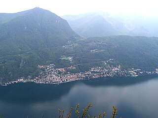
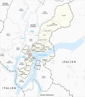
Lugano is a city and municipality in Switzerland, part of the Lugano District in the canton of Ticino. It is the largest city of both Ticino and the Italian-speaking southern Switzerland. Lugano has a population of 62,315, and an urban agglomeration of over 150,000. It is the ninth largest Swiss city.
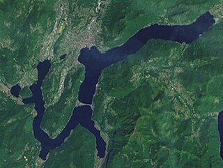
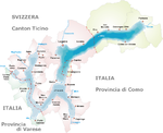
Lake Lugano is a glacial lake which is situated on the border between southern Switzerland and northern Italy. The lake, named after the city of Lugano, is situated between Lake Como and Lago Maggiore. It was cited for the first time by Gregory of Tours in 590 with the name Ceresio, a name which is said to have derived from the Latin word cerasus, meaning cherry, and refers to the abundance of cherry trees which at one time adorned the shores of the lake. The lake appears in documents in 804 under the name Laco Luanasco.

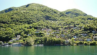
Gandria is both a quarter of the city of Lugano in the Swiss canton of Ticino, and a village on the northern shore of Lake Lugano, which forms the core of that quarter. Until 2004, the quarter of Gandria was an independent municipality, joining with Lugano in that year.
Campione d'Italia is a comune of the Province of Como in the Lombardy region of Italy and an exclave surrounded by the Swiss canton of Ticino. At its closest, the exclave is less than one kilometre (0.6 mi) from the rest of Italy, but the intervening mountainous terrain requires a journey by road of over 14 km (9 mi) to reach the nearest Italian town, Lanzo d'Intelvi, and over 28 km (17 mi) to reach the city of Como.

The Monte Generoso Railway or Ferrovia Monte Generoso (MG) is a mountain railway line in the Italian speaking canton of Ticino, in south-east Switzerland. The line runs from Capolago, on Lake Lugano, to a terminus near the summit of Monte Generoso. It is the highest railway in Ticino. The summit offers extensive views over the Lombardy Plain, part of the Po Valley, and towards the Alps.

Caslano is a municipality in the district of Lugano in the Swiss canton of Ticino, near to the Italian border.

Ponte Tresa is a former municipality in the district of Lugano in the canton of Ticino in Switzerland. On 18 April 2021 the municipalities of Croglio, Monteggio, Ponte Tresa and Sessa merged to form Tresa.

Capolago is a village situated at the south-eastern extremity of Lake Lugano, in the Swiss canton of Ticino. Originally a municipality in its own right, Capolago is now a quarter of the municipality of Mendrisio, itself part of the district of Mendrisio.

Paradiso is a municipality in the district of Lugano in the canton of Ticino in Switzerland. It lies on the shore of Lake Lugano and, although administratively independent of the city of Lugano, it is surrounded on all other sides by that city.
Caprino is a village on the southern shore of Lake Lugano in the Swiss canton of Ticino, to the east of the Italian exclave of Campione d'Italia and below the summit of Sighignola. Some 0.5 kilometres (0.31 mi) east of Caprino village is Cantine di Caprino, a smaller settlement. Politically both form part of the Castagnola-Cassarate quarter of the city of Lugano, although until 1972 Castagnola-Cassarate was an independent municipality under the name Castagnola.

The Comunità tariffale Ticino e Moesano, also known by its marketing name arcobaleno, is a Swiss tariff network covering the whole of the canton of Ticino, together with the Moesano district of the canton of Graubünden.

The Società Navigazione del Lago di Lugano or Lake Lugano Navigation Company (SNL) is a Swiss company operating passenger services on Lake Lugano. The company also operates bus routes in the same area, and is based at Cassarate in the city of Lugano. It was formerly known as the Società di Navigazione e Ferrovie per lago di Lugano and at one time also operated railways in the area.

Besso is a quarter of the city of Lugano, in the Swiss canton of Ticino. It forms the part of the city which is uphill of Lugano railway station, and is separated from the city centre by that station and its rail approaches. Besso was developed as a residential area in the late nineteenth century, driven by the opening of the railway in 1882. By 2011, it had a population of 4,993.

Castagnola-Cassarate is a quarter of the city of Lugano, in the Swiss canton of Ticino.
Loreto is a quarter of the city of Lugano, in the Swiss canton of Ticino. It forms the part of the city which surrounds the shrine of Our Lady of Loreto to the south of the city center, and includes the Lake Lugano waterfront south of the city centre but north of Paradiso. In 2011, it had a population of 3,221.

The Melide causeway crosses across Lake Lugano in the Swiss canton of Ticino, connecting the communities of Melide and Bissone, and provides the only domestic land connection between the southern section of Ticino, around Mendrisio and Chiasso, and the rest of Switzerland.

The Menaggio–Porlezza railway was a railway in the Italian province of Como. The line connected the town of Menaggio, on Lake Como, with Porlezza, on Lake Lugano, and was built as part of a multi-modal transport link between Menaggio and Luino, on Lake Maggiore.

Ponte Tresa railway station is a railway station in the municipality of Ponte Tresa in the Swiss canton of Ticino. The station is the terminus of the metre gauge Lugano–Ponte Tresa railway (FLP), from Lugano.
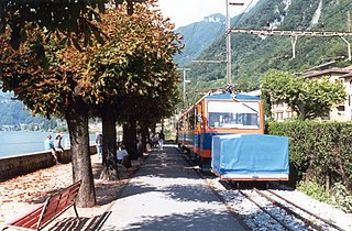
Capolago Lago is an infrequently served railway station on the Monte Generoso railway, a rack railway that connects Capolago with the summit of Monte Generoso in the Swiss canton of Ticino. The station is the lower terminus of the line, and provides interchange with ships of the Società Navigazione del Lago di Lugano at an immediately adjacent jetty on Lake Lugano.