Tabor, Iowa

Last updated
Tabor, Iowa
Tabor, IA.jpg
Fremont County Iowa Incorporated and Unincorporated areas Tabor Highlighted.svg
Location of Tabor, Iowa
Coordinates: 40°53′42″N95°40′25″W / 40.89500°N 95.67361°W / 40.89500; -95.67361
Country Flag of the United States.svg  United States
State Flag of Iowa.svg  Iowa
Counties Fremont, Mills
Area
[1]
  Total1.29 sq mi (3.35 km2)
  Land1.29 sq mi (3.35 km2)
  Water0.00 sq mi (0.00 km2)
Elevation
[2]
1,240 ft (380 m)
Population
 (2020)
  Total1,014
  Density784.83/sq mi (303.08/km2)
Time zone UTC-6 (Central (CST))
  Summer (DST) UTC-5 (CDT)
ZIP code
51653
Area code 712
FIPS code 19-76935
GNIS feature ID468776 [2]
Website www.taboriowa.us

Tabor is a city in Fremont County and extends northward into Mills County [3] in the U.S. state of Iowa. The population was 928 at the time of the 2020 census. [4]

Contents

Geography

According to the United States Census Bureau, the city has a total area of 1.29 square miles (3.34 km2), all land. [5]

History

Tabor College, ca. 1893 Tabor College in Iowa.JPG
Tabor College, ca. 1893

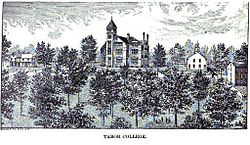
In 1852 the city of Tabor was founded by "a few families from Oberlin, Ohio, almost all of them Congregationalists," [6] "generous people, early settlers from New England and Ohio who had brought with them Puritan ideas of religion, and Sumner's and Phillips' and Garrison's ideas of freedom." [7] Among them were the Christian clergymen George Gaston, Samuel A. Adams, and Rev. John Todd, and their families. They chose to settle in what is now Tabor in order to found a Christian college, which eventually became Tabor College. The founders were impressed with this high location and mutually selected the name "Tabor" after the Biblical name of Mount Tabor, a mountain near Nazareth, the town of Jesus' childhood. [8]

The town was the home of many abolitionists; Rev. Todd, co-founder of Tabor College, was a "conductor" on the Underground Railroad. The residents of Tabor held monthly abolitionist prayer meetings, [9] :90 and helped runaway slaves whenever they could. [9] :111

During the Bleeding Kansas period (1854–1860), Tabor was on a route established to enable anti-slavery partisans to reach Kansas without needing to go through the slave state of Missouri. [6] A shipment of 200 Sharps rifles, sent from Boston for use in Kansas by free-state partisans, were stored there (in John Todd's barn). [6] In 1857–1858 abolitionist John Brown spent the winter in Tabor, assembling and training men for his raid on Harpers Ferry. [6]

Tabor College was located in the city from 1853 until 1927, when it closed for financial reasons. The college's buildings housed German Prisoners of War during World War II.

The Tabor & Northern Railway, a 9-mile line connecting with the Wabash Railroad at Malvern, operated from 1889 to 1934. [10] It was operated by the College. [11]

Demographics

Historical populations
YearPop.±%
1870 310    
1880 320+3.2%
1890 503+57.2%
1900 934+85.7%
1910 909−2.7%
1920 1,186+30.5%
1930 1,017−14.2%
1940 976−4.0%
1950 869−11.0%
1960 909+4.6%
1970 957+5.3%
1980 1,088+13.7%
1990 994−8.6%
2000 993−0.1%
2010 1,040+4.7%
2020 928−10.8%
Source: "U.S. Census website". United States Census Bureau . Retrieved 2020-03-29. and Iowa Data Center
Source:
U.S. Decennial Census [12] [4]

2010 census

At the 2010 census, [13] there were 1,040 people, 418 households and 272 families living in the city. The population density was 806.2 per square mile (311.3/km2). There were 451 housing units at an average density of 349.6 per square mile (135.0/km2). The racial makeup was 98.5% White, 0.7% African American, 0.3% Asian, 0.1% from other races, and 0.5% from two or more races. Hispanic or Latino of any race were 2.0% of the population.

There were 418 households, of which 29.9% had children under the age of 18 living with them, 50.2% were married couples living together, 10.0% had a female householder with no husband present, 4.8% had a male householder with no wife present, and 34.9% were non-families. 31.6% of all households were made up of individuals, and 15% had someone living alone who was 65 years of age or older. The average household size was 2.34 and the average family size was 2.95.

The median age was 44.3 years. 23.2% of residents were under the age of 18; 6.2% were between the ages of 18 and 24; 21.3% were from 25 to 44; 27.1% were from 45 to 64; and 22.2% were 65 years of age or older. The gender makeup of the city was 48.3% male and 51.7% female.

2000 census

At the 2000 census, [14] there were 993 people, 387 households and 267 families living in the city. The population density was 777.4 inhabitants per square mile (300.2/km2). There were 416 housing units at an average density of 325.7 per square mile (125.8/km2). The racial makeup was 99.60% White, 0.10% Asian, and 0.30% from two or more races. 0.81% of the population was Hispanic or Latino of any race.

There were 387 households, of which 30.5% had children under the age of 18 living with them, 55.6% were married couples living together, 11.6% had a female householder with no husband present, and 31.0% were non-families. 28.7% of all households were made up of individuals, and 20.2% had someone living alone who was 65 or older. The average household size was 2.38 and the average family size was 2.91.

24.1% of the population were under the age of 18, 5.2% from 18 to 24, 22.6% from 25 to 44, 23.0% from 45 to 64, and 25.2% who were 65 years of age or older. The median age was 44 years. For every 100 females, there were 84.6 males. For every 100 females age 18 and over, there were 74.1 males.

The median household income was $36,750 and the median family income was $50,000. Males had a median income of $31,042 and females $23,068The per capita income was $16,979. About 3.7% of families and 7.9% of the population were below the poverty line, including 11.5% of those under age 18 and 9.0% of those age 65 or over.

Education

Fremont–Mills Community School District operates public schools. [15]

National Historic Places and attractions

Cultural references

The town of Gilead, in Marilynne Robinson's Gilead , is a fictionalised version of Tabor. [16]

See also

Related Research Articles

<span class="mw-page-title-main">Fremont County, Iowa</span> County in Iowa, United States

Fremont County is a county located in the U.S. state of Iowa. As of the 2020 census the population was 6,605, making it the state's seventh-least populous county. The county seat is Sidney. The county was formed in 1847 and named for the military officer John C. Fremont.

<span class="mw-page-title-main">Waukon, Iowa</span> City in Iowa, United States

Waukon is a city in Makee Township, Allamakee County, Iowa, United States, and the county seat of Allamakee County. The population was 3,827 at the time of the 2020 census.

<span class="mw-page-title-main">Sheldahl, Iowa</span> City in Iowa, United States

Sheldahl is a city in Polk, Boone, and Story counties in the U.S. state of Iowa. The population was 297 at the time of the 2020 census.

<span class="mw-page-title-main">Manning, Iowa</span> City in Iowa, United States

Manning is a city in Carroll County, Iowa, United States, along Iowa Highway 141. The population was 1,455 at the time of the 2020 census. It is named for Orlando Harrison Manning, a Lieutenant Governor of Iowa.

<span class="mw-page-title-main">Waukee, Iowa</span> City in Iowa, United States

Waukee is a city in Dallas County, Iowa, United States. The population was 23,940 at the time of the 2020 U.S. Census. It is part of the Des Moines – West Des Moines Metropolitan Statistical Area.

<span class="mw-page-title-main">Farragut, Iowa</span> City in Iowa, United States

Farragut is a city in Fremont County, Iowa, United States. The population was 490 at the time of the 2020 census.

<span class="mw-page-title-main">Imogene, Iowa</span> City in Iowa, United States

Imogene is a city in Fremont County, Iowa, United States. The population was 39 at the time of the 2020 census.

<span class="mw-page-title-main">Randolph, Iowa</span> City in Iowa, United States

Randolph is a city in Fremont County, Iowa, United States. The population was 189 at the time of the 2020 census. It is the birthplace of Virginia Smith, Republican U.S. representative from the 3rd District of Nebraska from 1975 until 1991.

<span class="mw-page-title-main">Riverton, Iowa</span> City in Iowa, United States

Riverton is a city in Fremont County, Iowa, United States, along the East Nishnabotna River. The population was 245 at the time of the 2020 census.

<span class="mw-page-title-main">Sidney, Iowa</span> City in Iowa, United States

Sidney is a city in Fremont County, Iowa, United States. The population was 1,070 at the time of the 2020 census. It is the county seat of Fremont County and is one of the smallest county seats in the state.

<span class="mw-page-title-main">Thurman, Iowa</span> City in Iowa, United States

Thurman is a city in Fremont County, Iowa. As of the 2020 census, the city population was 167.

<span class="mw-page-title-main">Missouri Valley, Iowa</span> City in Iowa, United States

Missouri Valley is a city in Harrison County, Iowa, United States. The population was 2,678 at the time of the 2020 census.

<span class="mw-page-title-main">Earlham, Iowa</span> City in Iowa, United States

Earlham is a city in Madison County, Iowa, United States. The population was 1,410 at the time of the 2020 census. It is part of the Des Moines–West Des Moines Metropolitan Statistical Area.

<span class="mw-page-title-main">East Peru, Iowa</span> City in Iowa, United States

East Peru is a city in Madison County, Iowa, United States. The population was 115 at the time of the 2020 census. It is part of the Des Moines–West Des Moines Metropolitan Statistical Area.

<span class="mw-page-title-main">Fremont, Iowa</span> City in Iowa, United States

Fremont is a city in Mahaska County, Iowa, United States. The population was 708 at the time of the 2020 census.

<span class="mw-page-title-main">Malvern, Iowa</span> City in Iowa, United States

Malvern is a city in Mills County, Iowa, United States. The population was 1,046 at the time of the 2020 census. The Wabash Trace—a railroad converted to a bicycle trail—passes through Malvern. The Mills County Fair is held here, although Glenwood is the county seat. Malvern is the largest town in the eastern half of the county.

<span class="mw-page-title-main">Polk City, Iowa</span> City in Iowa, United States

Polk City is a city in Polk County, Iowa, United States. The population was 5543 in the 2020 census, an increase from 2,344 in 2000. It is part of the Des Moines–West Des Moines Metropolitan Statistical Area.

<span class="mw-page-title-main">Kirkville, Iowa</span> City in Iowa, United States

Kirkville is a city in Wapello County, Iowa, United States. The population was 157 at the time of the 2020 census.

<span class="mw-page-title-main">Shenandoah, Iowa</span> City in Iowa, United States

Shenandoah is a city in Page and Fremont counties in Iowa, United States. The population was 4,925 at the time of the 2020 U.S. Census. Once referred to as the "seed and nursery center of the world," Shenandoah is the home to Earl May Seed Company and the radio station KMA, founded by Earl E. May. The early live radio stations gave many performers their start, including The Everly Brothers and Charlie Haden.

<span class="mw-page-title-main">Carlisle, Iowa</span> City in Iowa, United States

Carlisle is a city in Warren and Polk counties in the U.S. state of Iowa. The population was 4,160 at the 2020 census. The city is part of the Des Moines–West Des Moines Metropolitan Statistical Area.

References

  1. "2020 U.S. Gazetteer Files". United States Census Bureau. Retrieved March 16, 2022.
  2. 1 2 U.S. Geological Survey Geographic Names Information System: Tabor, Iowa
  3. Mills County, Iowa historic map
  4. 1 2 "2020 Census State Redistricting Data". census.gov. United states Census Bureau. Retrieved 12 August 2021.
  5. "US Gazetteer files 2010". United States Census Bureau. Archived from the original on 2012-01-25. Retrieved 2012-05-11.
  6. 1 2 3 4 Richman, Irving B. (1894). "John Brown among the Quakers". John Brown among the Quakers, and other sketches. Des Moines, Iowa: Historical Department of Iowa. pp. 11–59, at pp. 14–16.
  7. Harris, Ransom Langdon (Oct 1894). "John Brown and his followers in Iowa". Midland Monthly Magazine . Vol. 2, no. 4. pp. 262–268.
  8. Tabor Historical Society (2011). "Tabor College". Archived from the original on July 26, 2019.
  9. 1 2 Soike, Lowell J. (2013). Necessary Courage: Iowa's Underground Railroad in the Struggle against Slavery. Iowa City, Iowa: University of Iowa Press. ISBN   978-1-60938-193-6 via Project MUSE.
  10. Grant, H. Roger (2000). Iowa Railroads: The Essays of Frank P. Donovan, Jr. Iowa City, Iowa: University of Iowa Press. p. 247. ISBN   0877457158 via Project MUSE.
  11. "'Flivver Engines' Are Motive Power for Iowa Railroad Owned in Tabor". Des Moines Register (Des Moines, Iowa). June 24, 1928. p. 2 via newspapers.com.
  12. "Census of Population and Housing". Census.gov. Retrieved June 4, 2015.
  13. "U.S. Census website". United States Census Bureau . Retrieved 2012-05-11.
  14. "U.S. Census website". United States Census Bureau . Retrieved 2008-01-31.
  15. "Fremont-Mills." Iowa Department of Education. Retrieved June 18, 2018.
  16. "Marilynne Robinson | The Writing University". www.writinguniversity.org. Archived from the original on 2012-02-29.