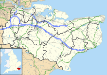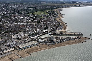
Whitstable is a town on the north coast of Kent, England, at the convergence of the Swale and the Greater Thames Estuary, five miles north of Canterbury and two miles west of Herne Bay.

The Swale is a tidal channel of the Thames estuary that separates the Isle of Sheppey from the rest of Kent. On its banks is a 6,509.4-hectare (16,085-acre) biological Site of Special Scientific Interest which stretches from Sittingbourne to Whitstable in Kent. It is also a Ramsar internationally important wetland site and a Special Protection Area under the European Union Directive on the Conservation of Wild Birds. Parts of it are a Nature Conservation Review site, Grade I, National Nature Reserves, a Kent Wildlife Trust nature reserve and a Local Nature Reserve.
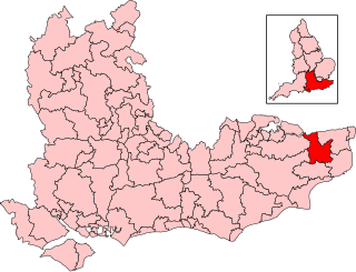
Canterbury is a constituency in Kent represented in the House of Commons of the UK Parliament since 2017 by Rosie Duffield formerly of the Labour Party and since September 2024 an Independent.

Beacon Hill is near the village of Burghclere and Watership Down, in north Hampshire. The hill's name is derived from the fact that it was one of many Beacon Hills in England and beyond. This hill was once the site of the most famous beacon in Hampshire. It is 261 metres high and has one of England's most well known hill forts on its slopes, visible from the main A34 road which passes close by. From there, outstanding views of the surrounding area and much of Hampshire may be obtained. The site is open to the public and managed by Hampshire County Council. It is an 80.7-hectare (199-acre) biological Site of Special Scientific Interest called Burghclere Beacon and a Nature Conservation Review site, Grade I.

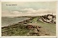
Tankerton is a suburb of Whitstable in Kent in south-east England. It was designed in the late 19th century as the train network brought holidaymakers to the sea. It gives its name to a ward of Canterbury City Council.

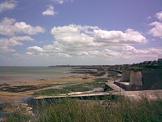
Swalecliffe is a part of the ribbon development of the north Kent coast between Whitstable and Herne Bay in Southeast England. It forms Swalecliffe ward of City of Canterbury Council.

Park Gate Down or Parkgate Down is a 7-hectare (17-acre) biological Site of Special Scientific Interest south-east of Stelling Minnis in Kent. It is also a Special Area of Conservation and is managed by the Kent Wildlife Trust,

The Kentish Flats Offshore Wind Farm is a wind farm located off the coast of Kent, England on a large, flat and shallow plateau just outside the main Thames shipping lanes. The wind farm is operated by Vattenfall.

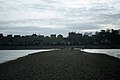
Seasalter is a village in the Canterbury district of Kent, England. Seasalter is on the north coast of Kent, between the towns of Whitstable and Faversham, facing the Isle of Sheppey across the estuary of the River Swale. The settlement of Yorkletts is included in the ward. It is approximately 6 miles (10 km) north of Canterbury.

Hampton-on-Sea is a drowned and abandoned village in what is now the Hampton area of Herne Bay, Kent. It grew from a tiny fishing hamlet in 1864 at the hands of an oyster fishery company, was developed from 1879 by land agents, abandoned in 1916 and finally drowned due to coastal erosion by 1921. All that now remains is the stub of the original pier, the Hampton Inn, and the rocky arc of Hampton-on-Sea's ruined coastal defence visible at low tide. The site is notable for sharing its history with the eccentric Edmund Reid. Reid was previously the Metropolitan Police head of CID who handled the Jack the Ripper case. In retirement he chose to champion the plight of the beleaguered residents of the settlement.

Hamford Water is a 2,185.8-hectare (5,401-acre) biological Site of Special Scientific Interest between Walton-on-the-Naze and Harwich in Essex. The site is a tidal inlet which has marsh grasslands, creeks, mud and sand flats, salt marshes, islands and beaches. It is described by Natural England as "of international importance for breeding little terns and wintering dark-bellied brent geese, wildfowl and waders, and of national importance for many other bird species." Rare plants include hog's fennel and slender hare's-ear. The main invertebrates are worms and thin-shelled molluscs. The largest island, Horsey Island, can be reached on foot at low tide across The Wade from Kirby-le-Soken.

Hog's Hole is a 23.7-hectare (59-acre) biological Site of Special Scientific Interest in the civil parish of Combe in the English county of Berkshire.

Lympne Escarpment is a 140.2-hectare (346-acre) biological Site of Special Scientific Interest west of Hythe in Kent. Part of it is the remains of a Saxon Shore fort now called Stutfall Castle, which is a Scheduled Monument.

Magpie Bottom is a 51.9-hectare (128-acre) biological Site of Special Scientific Interest north of Sevenoaks in Kent.

Sheppey Cliffs and Foreshore is a 303.6-hectare (750-acre) biological and geological Site of Special Scientific Interest which stretches between Minster and Leysdown-on-Sea in Kent, England. It includes five Geological Conservation Review sites. This site exposes Eocene London Clay with well-preserved fossil fauna and flora, which have been studied since the eighteenth century.
Thanet Coast is an 816.9-hectare (2,019-acre) biological and geological Site of Special Scientific Interest which stretches along the coast between Whitstable and Ramsgate in Kent. It is a Geological Conservation Review site, and overlaps two Special Area of Conservations. It is also part of a Ramsar Site and a Special Protection Area. Part of it is a Local Nature Reserve,
The 1989–90 Kent Football League season was the twenty-fourth in the history of the Kent Football League, a football competition featuring teams based in and around the county of Kent in England.
The 1981–82 Kent Football League season was the sixteenth in the history of the Kent Football League, a football competition featuring teams based in and around the county of Kent in England.
The 1979–80 Kent Football League season was the fourteenth in the history of the Kent Football League, a football competition featuring teams based in and around the county of Kent in England.