King is a township in York Region north of Toronto, within the Greater Toronto Area in Ontario, Canada.

Mount Forest is an unincorporated community located at the junction of Highway 6 and Highway 89 in the township of Wellington North, Ontario, Canada. As of the 2011 Canadian census the population of Mount Forest was 4,757.

Elizabethtown-Kitley is a township in eastern Ontario, Canada, in the United Counties of Leeds and Grenville. Its southern border lies along the St. Lawrence River and it extends north into many rural hamlets and villages. The township was created on January 1, 2001 by the amalgamation of the former Township of Elizabethtown and Township of Kitley.
King City is an unincorporated Canadian community in the township of King, Ontario, located 40 kilometres (25 mi) north of Toronto. It is the largest community in King township, with 2,730 dwellings and a population of 8,396 as of the 2021 Canadian census.

Bathurst Street is a main north–south thoroughfare in Toronto, Ontario, Canada. It begins at an intersection of the Queens Quay roadway, just north of the Lake Ontario shoreline. It continues north through Toronto to the Toronto boundary at Steeles Avenue. It is a four-lane thoroughfare throughout Toronto. The roadway continues north into York Region where it is known as York Regional Road 38.

Oak Ridges is an unincorporated community of Richmond Hill, Ontario, Canada, and has been part of the city since 1971. It forms the northern portion of the municipality's boundary, where it borders Aurora. Located about 20 km north of the northern border of Toronto and about 35 km from Downtown Toronto, it has a population of 18,520 (2016). The community developed around Lake Wilcox, the largest lake in the area, and has continued to expand slowly since its annexation by the Town of Richmond Hill. In the 1990s, Oak Ridges experienced moderate growth, which spurred environmental action by numerous organizations. Population has grown significantly as a result of development initiatives along Bayview Avenue. The Oak Ridges Community Center was built and completed in June 2012 to accommodate community demand.
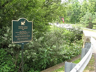
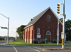
Kettleby is an unincorporated community in the northeastern part of King Township in Ontario, Canada. It is located about 1.5 kilometres (0.93 mi) east of Highway 400, 25 kilometres (16 mi) north of Toronto, about 40 kilometres (25 mi) south of Barrie, 6 kilometres (3.7 mi) west of Newmarket, and about 50 kilometres (31 mi) east of Orangeville.

The Randolph Theatre is a 518 seat theatre in Toronto, Ontario, that is housed in a former church. The Gothic revival building is located at 736 Bathurst Street at the intersection with Lennox Street. The theatre is in the former church sanctuary, while the 100-seat Annex Theatre is in an adjoining building at 730 Bathurst Street.

Edwardsburgh/Cardinal is a township in the United Counties of Leeds and Grenville of eastern Ontario, Canada. Edwardsburgh township was first surveyed in 1783, and incorporated in 1850. The township was part of the historical Grenville County before it merged with Leeds County to form the United Counties in the 19th century.

Augusta Township is a township in the United Counties of Leeds and Grenville, located in eastern Ontario, Canada. Augusta is situated along the Saint Lawrence River, and extends back into rural hamlets. The township is located between the city of Brockville to the west, and the town of Prescott to the east.

North Gower is a small village in eastern Ontario, originally part of North Gower Township, now part of the city of Ottawa. Surrounding communities include Richmond, Kemptville, Kars and Manotick. Public high school students in this area go to South Carleton High School in Richmond.
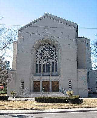
The Holy Blossom Temple is a Reform synagogue located at 1950 Bathurst Street in Toronto, Ontario, Canada. It is the oldest Jewish congregation in Toronto. Founded in 1856, it has more than 7,000 members. W. Gunther Plaut, who died on 8 February 2012 at the age of 99, was a long time Senior Rabbi for this synagogue. Notable members and supporters include Heather Reisman and Gerald Schwartz who made donations to create the Gerald Schwartz/Heather Reisman Centre for Jewish Learning at Holy Blossom Temple.

Little Trinity Anglican Church is a parish church of the Anglican Church of Canada. It is located at 425 King Street East in the Corktown neighbourhood, just east of downtown Toronto, Ontario, Canada. An Ontario Heritage Trust plaque at the site notes that the 1844 church is the oldest surviving church in the city.

Blandford-Blenheim is a township in the Canadian province of Ontario, located in Oxford County. The township had a population of 7,359 in the Canada 2011 Census.
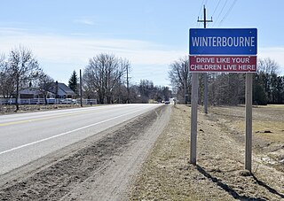
Winterbourne is a village located to the east of the Grand River in the township of Woolwich in the Regional Municipality of Waterloo, Ontario, Canada. It is located just northeast of the city of Waterloo. The fine stonework of the Scottish stonemasons can be seen in many of the older buildings throughout the settlement.
Victoria Square is an unincorporated community in Markham, Ontario, Canada. The community was formed in the early nineteenth century.
Cedar Grove is a community in Markham, Ontario on the Little Rouge River. It is centred on 14th Avenue and Reesor Road and within the boundaries of the future national Rouge Park.
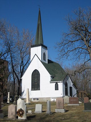
The Church of St. Jude is an historic church in the Scarborough area of Toronto, Ontario, Canada. St. Jude's was originally built in what was the small rural village of Wexford, Ontario in 1848. The original church building survives today, being used as the cemetery chapel, making it one of the oldest surviving churches in Scarborough. The land for the church was donated to Bishop John Strachan and the Anglican Diocese of Toronto by Patrick and Ann Parkin. They had used this corner of their farm as a family cemetery. The church was built atop a small hill, so that it dominated the surrounding landscape. The still operational cemetery surrounds the church, and has graves dating back to 1832. Local farmers built the church with lumber milled from nearby trees. The Gothic revival structure was designed by Reverend William Darling, the Anglican minister for Scarborough township. It is a replica in miniature of a church he remembered from his native Scotland. Keeping the proportions of the original while greatly shrinking the structure explains why the sacristy entrance is only five feet high. Darling's son, Frank Darling, would later become a prominent Toronto architect himself.

Asbury & West United Church is a United Church of Canada church in the Bathurst and Lawrence area of Toronto, Ontario, Canada. The congregation has one of the longest continual histories of any in Toronto. It traces its history back to 1812 and meetings of small groups of Methodist settlers in what was an area being newly settled by Europeans. The first services were held in the farmhouse of Henry Mulholland, a veteran of the War of 1812 and the Battle of Lundy's Lane. He first came to Canada from Ireland in 1806, settling in the area that would later be named Henry Farm after him. He later moved further west to what is now the Bathurst and Lawrence area.
Walton is a Southwestern Ontario hamlet in Huron County, Ontario, Canada, located at the intersection of Huron County Road 12 and Road 25, 45 km east of Goderich.