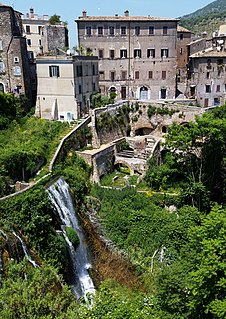
Tivoli is a town and comune in Lazio, central Italy, 30 kilometres north-east of Rome, at the falls of the Aniene river where it issues from the Sabine hills. The city offers a wide view over the Roman Campagna.

The Esquiline Hill is one of the Seven Hills of Rome. Its southernmost cusp is the Oppius.
The Caelian Hill is one of the famous seven hills of Rome.

Santa Maria sopra Minerva is one of the major churches of the Roman Catholic Order of Preachers in Rome, Italy. The church's name derives from the fact that the first Christian church structure on the site was built directly over the ruins or foundations of a temple dedicated to the Egyptian goddess Isis, which had been erroneously ascribed to the Greco-Roman goddess Minerva.

I quattro libri dell'architettura is a treatise on architecture by the architect Andrea Palladio (1508–1580), written in Italian. It was first published in four volumes in 1570 in Venice, illustrated with woodcuts after the author's own drawings. It has been reprinted and translated many times, often in single-volume format.

Hadrian's Villa is a UNESCO World Heritage Site comprising the ruins and archaeological remains of a large villa complex built c. AD 120 by Roman Emperor Hadrian at Tivoli outside Rome. The site is owned by the Republic of Italy and has been managed since 2014 by the Polo Museale del Lazio.

Santa Bibiana is a small Baroque style, Roman Catholic church in Rome devoted to Saint Bibiana. The church façade was designed and built by Gian Lorenzo Bernini, who also produced a sculpture of the saint holding the palm leaf of martyrs.

The Parian marble Athena Giustiniani or Giustiniani Minerva is an Antonine Roman marble copy of a Greek sculpture of Pallas Athena, of the late fifth-early fourth century BCE.

San Teodoro is a 6th-century church in Rome. It was dedicated to Theodore of Amasea and given to the Eastern Orthodox community of Rome by Pope John Paul II in 2004. It is located on an ancient road between the Roman Forum and Forum Boarium, along the north-western foot of the Palatine Hill.
The Horti Liciniani was a luxurious complex of an ancient Roman villa with large gardens and outdoor rooms originally belonging to the gens Licinia. It was located in Rome on the Esquiline Hill between via Labicana and via Prenestina, close to the Aurelian walls. They bordered the Horti Tauriani to the north and the Horti Pallantiani and Horti Epaphroditiani to the west.

Phoenicia under Roman rule describes the Syro-Phoenician city states ruled by Rome from 64 BCE to the Muslim conquests of the 7th century. The area around Berytus was the only Latin speaking and Romanized part of Aramaic-speaking Phoenicia.

The Villa of the Quintilii is an ancient Roman villa beyond the fifth milestone along the Via Appia Antica just outside the traditional boundaries of Rome, Italy. It was built by the rich and cultured brothers Sextus Quintilius Valerius Maximus and Sextus Quintilius Condianus.
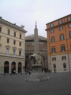
Piazza della Minerva is a piazza in Rome, Italy, near the Pantheon. Its name derives from the existence of a temple built on the site by Pompey dedicated to Minerva Calcidica, whose statue is now in the Vatican Museums.
The temple of Minerva Medica was a temple in ancient Rome, built on the Esquiline Hill in the Republican era, though no remains of it have been found. Since the 17th century, it has been wrongly identified with the ruins of a nymphaeum on a nearby site, on account of the erroneous impression that the Athena Giustiniani had been found in its ruins.

The Villa dei Sette Bassi is an archaeological site located in Rome, Italy.
Domes were a characteristic element of the architecture of Ancient Rome and of its medieval continuation, the Byzantine Empire. They had widespread influence on contemporary and later styles, from Russian and Ottoman architecture to the Italian Renaissance and modern revivals. The domes were customarily hemispherical, although octagonal and segmented shapes are also known, and they developed in form, use, and structure over the centuries. Early examples rested directly on the rotunda walls of round rooms and featured a central oculus for ventilation and light. Pendentives became common in the Byzantine period, provided support for domes over square spaces.

The Temple of Claudius, also variously known as the Temple of the Divus Claudius, the Temple of the Divine Claudius, the Temple of the Deified Claudius, or in an abbreviated form as the Claudium, was an ancient structure that covered a large area of the Caelian Hill in Rome, Italy. It housed the Imperial cult of the Emperor Claudius, who was deified after his death in 54 AD.

