The Naval Air Station's WWII seawall, runway, and some of the buildings remain.[2]
History
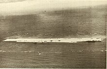
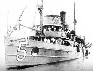
Tern Island in September 1943United States Coast Guard PBY-5A at Tern Island in 1953Tern Island, the French Frigate Shoals airfield
After the 1942 Battle of Midway, the U.S. Navy built a Naval Air Station there, .enlarging the island to support a 3300ft. (1005 m) landing strip. Construction started in July 1942. They constructed a 5000-foot double steel pylon seawall, with walls separated by 4 feet.[4] The original seawall used over 5000 steel pilings.[5] Maintenance was conducted by the U.S. Coast Guard while it operated there.[4]
The facility was commissioned in March 1943.[5] The station's main function was as an emergency landing site for planes flying between Hawaii and Midway Atoll.[2]
The island was expanded from 11 acres to 34 acres, and supported parking spots for 22 aircraft.[4] A 90-foot-tall radar tower and barracks were added.[4] Reconnaissance air patrols were flown from the island.[4]
Base defenses included a battery of 90mm guns, 3-inch guns, and 30 calibre machine guns.[6] Approximately 130 people staffed the island.[7]
One emergency landing occurred in 1944, when a Curtiss C-46 Commando with dozens of marines aboard had an engine failure and was close to ditching in the ocean.[6][self-published source?] The twin-engine transport plane was down to an altitude of less than 300 feet, despite having dropped as much weight as possible when it managed to land on Tern Island.[6] The aircraft was able to land with one engine out, avoiding fatalities.[6]
In 1945, Tern Island landed the USMC comedy show All Fouled Up when the entourage's R4D aircraft could not land at Midway due to fog.[6] The show was performed for the crew there.[6]
The naval base operated until 1946, when it was replaced by two fisheries. The fish were flown to Honolulu on a DC-3 aircraft.[3]
A U.S. Coast Guard station operated from 1952 until 1979.[8] In 1969, a tsunami wiped out much of the station, which was repaired.[9] The crew was evacuated by helicopter by the ship HMNZS Waikato, and taken to Midway.[3] Also, from 1961 to 1983 a missile tracking station operated there.[5]
Between 1986 and 1991 Tern Island was used to study the green sea turtle (Chelonia mydas).[10]
One Piper Aztec landed over 600 times at Tern Island.[11] Monthly flights typically involved travel to Honolulu for mail, while heavier cargo usually comes by water.[12]
The barracks continued to be used into the 21st century.[11] Upgrades included the cleanup of old waste, improved water tanks, and solar power.[12] The solar power runs a reverse osmosis desalinator, capable of producing 1200 gallons a day.[12] A diesel generator runs off a 500-gallon fuel tank.[12]
After decades the steel wall became a marine life hazard, trapping seals and turtles. As a result, Congress approved about 10 million dollars along with another million from a Federal agency to repair it, from 2000 to 2003. However, the funds ran out halfway through.[13]
Sign noting Tern Island as part of a United States' nature reserve in the French Frigate shoalsA view of from Tern Island and in the distance, La Perouse PinnacleBirds and Tern Island structures
The United States Fish and Wildlife Service (FWS) operated a field station on the island from 1979 to 2012.[4] The wildlife station had between 5 and 15 staff.[7] Closure came after a storm in December 2012, when several people evacuated in advance of the storm.[14] The storm damaged facilities including the barracks.[14][15]
In the summer of 2004, 1200 feet of seawall were repaired, and the boat dock was replaced by a boat ramp for small boats.[16] However, thousands of feet of seawall were still in need of repair.[16]
In 2013, the island was imaged for a Google Street View project, to allow the islands to be viewed online.[2] Google and the US government worked to make five islands viewable.[2] The other Pacific islands were East Island (also in French Frigate Shoals), Laysan Island, Lisianski Island, and Pearl and Hermes Atoll.[17] The viewer offered a series of panoramic images from head height to be viewed around the island.[2] The path takes views along much of the length of the airstrip and part of the shore.[2]
In 2013 the NOAA ship Oscar Sette visited French Frigate Shoals and established a field camp on Tern Island. The storm at the end of 2012 had left the barracks uninhabitable, and the water system unusable.[18] Water had to be brought in jugs.[18]
In 2019, a survey of green sea turtles was conducted.[19] 371 were reported.[19]
In 2020, the beach was designated as polluted by plastic trash.[20] This ruling came after years of research, including 14.5 thousand kilograms of trash discovered within 5000 meters of the beach over 11 years.[20] Over 70 percent of the trash was plastic.[20] Debris accumulation was studied in the 2010s.[21] In the 2020s, researchers again noted the threat posed by the corroded double steel wall.
In 2020, the Papahanaumokuakea Marine Debris Project removed tens of tons of debris from French Frigate Shoals, including Tern Island.[22]
Birds
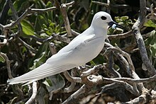
A white tern at Tern Island, 2006Albatrosses at Tern Island
The bird populations were studied.[23] One concern was birds eating plastic trash, which was studied between 2006 and 2013.[23] Tern Island is a popular research site to study Pacific sea- and shore-birds.[24]
Sixteen seabird species inhabited Tern Island in the early 21st century,[25] including:[24][25]
In 1998 and 1999, the black-footed albatross (Phoebastria nigripes) and Laysan albatross (Phoebastria immutabilis) were studied. The research recorded a particularly unsuccessful nesting season.[26]
A 2010 study noted that other rare birds were sometimes seen at Tern.[27] Examples include the short-eared owl (Asio flammeus) and fork-tailed swift (Apus pacificus).[27]
Tern Island is popular with green sea turtles; while in 1977 no nests were observed; twenty years later, this had grown to around 700 nests.[28]
Migratory shorebirds known to winter at Tern in the early 21st century include:[4]
Baker Island, formerly known as New Nantucket, is an uninhabited atoll just north of the Equator in the central Pacific Ocean about 3,090 km (1,920 mi) southwest of Honolulu. The island lies almost halfway between Hawaii and Australia. Its nearest neighbor is Howland Island, 42 mi (68 km) to the north-northwest; both have been claimed as territories of the United States since 1857, though the United Kingdom considered them part of the British Empire between 1897 and 1936.
Midway Atoll is a 2.4 sq mi (6.2 km2) atoll in the North Pacific Ocean. Midway Atoll is an insular area of the United States and is an unorganized and unincorporated territory. The largest island is Sand Island, which has housing and an airstrip. Immediately to the east of Sand Island across the narrow Brooks Channel is Eastern Island, which is uninhabited and no longer has any facilities. Forming a rough, incomplete circle around the two main islands and creating Midway Lagoon is Spit Island, a narrow reef.
Kure Atoll or Ocean Island is an atoll in the Pacific Ocean 48 nautical miles west-northwest of Midway Atoll in the Northwestern Hawaiian Islands at 28°25′N178°20′W. A coral ring 10 km across encloses a lagoon several meters deep. The only land of significant size is called Green Island and is a habitat for hundreds of thousands of seabirds. A short, unused and unmaintained runway and a portion of one building, both from a former United States Coast Guard LORAN station, are located on the island. Politically, it is part of Hawaii, although separated from the rest of the state by Midway, which is a separate unorganized territory. Green Island, in addition to being the nesting grounds for tens of thousands of seabirds, has recorded several vagrant terrestrial birds, including snow bunting, eyebrowed thrush, brambling, olive-backed pipit, black kite, Steller's sea eagle and Chinese sparrowhawk. It is currently managed as a Wildlife Bird Sanctuary by the State of Hawaii's Department of Land and Natural Resource–Division of Forestry and Wildlife as one of the co-trustees of Papahānaumokuākea Marine National Monument with support from the Kure Atoll Conservancy.
Necker Island is a small island in the Northwestern Hawaiian Islands. It is located at 23°34′30″N164°42′01″W in the Pacific Ocean, 430 miles northwest of Honolulu, Hawaii, 155 miles northwest of Nihoa, and 8 miles north of the Tropic of Cancer. It is part of the State of Hawaii in the United States. It contains important prehistoric archaeological sites of the Hawaiian culture and is part of the Hawaiian Islands National Wildlife Refuge within the Papahānaumokuākea Marine National Monument.
Nihoa, also known as Bird Island or Moku Manu, is the tallest of ten islands and atolls in the uninhabited Northwestern Hawaiian Islands (NWHI). The island is located at the southern end of the NWHI chain, 296 km (160 nmi) southeast of Necker Island. Nihoa is the closest NWHI in proximity to the eight main windward Hawaiian Islands at approximately 240 km (130 nmi) northwest of the island of Kauaʻi. The island has two peaks, 272 m (892 ft) Miller's Peak in the west, and 259 m (850 ft) Tanager Peak in the east. Nihoa's area is about 171 acres (0.69 km2) and is surrounded by a 142,000-acre (57,000 ha) coral reef. Its jagged outline gives the island its name, Nīhoa, which is Hawaiian for "toothed, serrated".
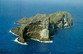
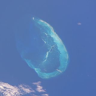
The French Frigate Shoals is the largest atoll in the Northwestern Hawaiian Islands. Its name commemorates French explorer Jean-François de Galaup, comte de Lapérouse, who nearly lost two frigates when attempting to navigate the shoals. It consists of a 20-mile-long (32 km) crescent-shaped reef, twelve sandbars, and the 120-foot-high (37 m) La Perouse Pinnacle, the only remnant of its volcanic origins. The total land area of the islets is 61.508 acres (24.891 ha), while the total coral reef area of the shoals is over 232,000 acres (94,000 ha). Tern Island, with an area of 26.014 acres (10.527 ha), has a landing strip and permanent habitations for a small number of people. It is maintained as a field station in the Hawaiian Islands National Wildlife Refuge by the United States Fish and Wildlife Service. The French Frigate Shoals are about 487 nautical miles northwest of Honolulu. Among the shoals are Tern, which is unique in having an airstrip and is protected by a seawall, and La Perouse Pinnacle, a tall and rocky island in the center of the shoals. The two largest islands after Tern, East and Trig have mostly washed away, with East being about half the size from storms, but are famed as breeding grounds for turtles. East was also home to Coast Guard base in the late 20th century. The islands are surrounded by a coral reef, and the islands themselves are noted breeding ground for turtles, seals, and birds. Habitation is difficult with little vegetation and no fresh water. In the 20th century the French Frigate Shoals are also called Lalo as part of the marine nature reserve, and along with other islands are visited periodically for research. The highest point in the shoals is on La Perouse Pinnacle which is a volcanic rock that rises 122 ft (37 m) above the surrounding lagoon.
The Northwestern Hawaiian Islands or Leeward Hawaiian Islands are a series of islands and atolls in the Hawaiian island chain located northwest of the islands of Kauai and Niʻihau. Politically, they are all part of Honolulu County in the U.S. state of Hawaii, except Midway Atoll, which is a territory distinct from the State of Hawaii, and grouped as one of the United States Minor Outlying Islands. The United States Census Bureau defines this area, except Midway, as Census Tract 114.98 of Honolulu County. Its total land area is 3.1075 square miles (8.048 km2). All the islands except Nihoa are north of the Tropic of Cancer, making them the only islands in Hawaii that lie outside the tropics.
The Pearl and Hermes Atoll, also known as Pearl and Hermes Reef, is part of the Northwestern Hawaiian Islands, a group of small islands and atolls that form the farthest northwest portion of the Hawaiian island chain. The atoll consists of a variable number of flat and sandy islets, typically between five and seven. More were noted in historical sources but have since been lost to erosion and rising sea levels.
The Hawaiian monk seal is an endangered species of earless seal in the family Phocidae that is endemic to the Hawaiian Islands.
Laysan is one of the Northwestern Hawaiian Islands, located 808 nautical miles northwest of Honolulu. It comprises one land mass of 1,016 acres (4.11 km2), about 1 by 1+1⁄2 miles in size. It is an atoll of sorts, although the land completely surrounds a shallow central lake some 2.4 m (7.9 ft) above sea level that has a salinity approximately three times greater than the ocean. Laysan's Hawaiian name, Kauō, means 'egg'.
Lisianski Island is one of the Northwestern Hawaiian Islands, with a land area of 384.425 acres (155.571 ha) and a maximum elevation of 40 feet (12 m) above sea level. It is a low, flat sand and coral island about 905 nautical miles northwest of Honolulu, Hawaii. The island is surrounded by reefs and shoals, including the extensive Neva Shoals. Access to the island is possible only by helicopter or by boat via a narrow sandy inlet on the southeastern side of the island.
The Laysan albatross is a large seabird that ranges across the North Pacific. The Northwestern Hawaiian Islands are home to 99.7% of the population. This small gull-like albatross is the second-most common seabird in the Hawaiian Islands, with an estimated population of 1.18 million birds, and is currently expanding its range to new islands. The Laysan albatross was first described as Diomedea immutabilis by Lionel Walter Rothschild, in 1893, on the basis of a specimen from Laysan Island.
The Papahānaumokuākea Marine National Monument (PMNM) is a World Heritage listed U.S. National Monument encompassing 583,000 square miles (1,510,000 km2) of ocean waters, including ten islands and atolls of the Northwestern Hawaiian Islands. It was created in June 2006 with 140,000 square miles (360,000 km2) and expanded in August 2016 by moving its border to the limit of the exclusive economic zone, making it one of the world's largest protected areas. It is internationally known for its cultural and natural values as follows:
The area has deep cosmological and traditional significance for living Native Hawaiian culture, as an ancestral environment, as an embodiment of the Hawaiian concept of kinship between people and the natural world, and as the place where it is believed that life originates and to where the spirits return after death. On two of the islands, Nihoa and Mokumanamana, there are archaeological remains relating to pre-European settlement and use. Much of the monument is made up of pelagic and deepwater habitats, with notable features such as seamounts and submerged banks, extensive coral reefs and lagoons.
The TanagerExpedition was a series of five biological surveys of the Northwestern Hawaiian Islands conducted in partnership between the Bureau of Biological Survey and the Bishop Museum, with the assistance of the United States Navy. Four expeditions occurred from April to August 1923, and a fifth in July 1924. Led by Lieutenant Commander Samuel Wilder King on the minesweeper USS Tanager (AM-5), and Alexander Wetmore directing the team of scientists, the expedition studied the plant animal life, and geology of the central Pacific islands. Noted members of the team include archaeologist Kenneth Emory and herpetologist Chapman Grant.
La Perouse Pinnacle is a steep basalt outcrop at French Frigate Shoals in the Pacific Ocean. Rising approximately 122 ft (37 m) above sea surface, it is the eroded plug of a shield volcano and caldera that formed 12million years ago. The rocky formation lies within the Papahānaumokuākea Marine National Monument. Because of its prominence and shape, the pinnacle can be mistaken for a sailing ship from a distance.
Hurricane Neki was the final tropical cyclone of the 2009 Pacific hurricane season. It developed on October 18 as an unusually large disturbance from a trough south of Hawaii. Moving northwestward, it organized only slowly at first due to its large size. After reaching hurricane status on October 21, Neki intensified at a much faster rate and peaked with winds of 125 mph (205 km/h). It later turned to the north and north-northeast and weakened due to hostile conditions. While passing through the Papahānaumokuākea Marine National Monument, Neki was downgraded to a tropical storm after the center became exposed from the deepest convection. It caused little impact in the island chain. After stalling and executing a small loop, Neki resumed its northward track and dissipated on October 27.
The Hawaii longline fishery is managed under Western Pacific Regional Fishery Management Council’s (WPRFMC's) Pelagics Fisheries Ecosystem Plan. Through this plan, the WPRFMC has introduced logbooks, observers, vessel monitoring systems, fishing gear modifications and spatial management for the Hawaii longline fishery. Until relatively recently, the main driver for management of the Hawaii longline fishery has been bycatch and not fishery resources.
East Island is an island, formerly about 11 acres (45,000 m2) in area, one-half mile (800 m) long and 400 feet (120 m) wide, now greatly reduced in size. It was the second-largest in the French Frigate Shoals, and is one of the Northwestern Hawaiian Islands, approximately 550 miles (890 km) northwest of Honolulu. It was largely washed away in 2018 by the storm surge from Hurricane Walaka. The remaining portion of the island above sea level consists of a sandy strip approximately 150 feet (46 m) long.
The Northwestern Hawaii scrub is a tropical and subtropical grasslands, savannas, and shrublands ecoregion on the Northwestern Hawaiian Islands in the Pacific Ocean.
Lindsay Young is an avian conservation biologist who has published over 110 journal articles and technical reports on Pacific Seabirds. She is currently Senior Scientist and Executive Director of the Pacific Rim Conservation. This nonprofit, research-based organization works to restore native seabird populations and ecosystems. She is also the current chair of the World Seabird Union. Young has also served as treasurer for the Pacific Seabird Group, as chair for the North Pacific Albatross Working Group, and as correspondent for the Agreement on the Conservation of Albatrosses and Petrels.
1 2 Rapp, Dan C.; Youngren, Sarah M.; Hartzell, Paula; David Hyrenbach, K. (October 15, 2017). "Community-wide patterns of plastic ingestion in seabirds breeding at French Frigate Shoals, Northwestern Hawaiian Islands". Marine Pollution Bulletin. 123 (1–2): 269–278. Bibcode:2017MarPB.123..269R. doi:10.1016/j.marpolbul.2017.08.047. ISSN1879-3363. PMID28844458.
This page is based on this Wikipedia article Text is available under the CC BY-SA 4.0 license; additional terms may apply. Images, videos and audio are available under their respective licenses.