
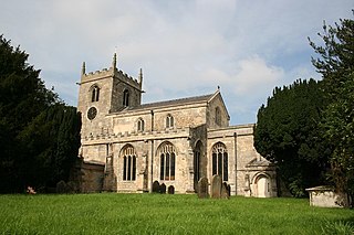
Theddlethorpe St Helen or East Theddlethorpe is a village and civil parish in the East Lindsey district of the county of Lincolnshire, England. It lies about 3 miles (5 km) north of Mablethorpe on the North Sea coast. The National Grid-owned Theddlethorpe Gas Terminal processes natural gas from the North Sea. Some seashore belongs to Saltfleetby-Theddlethorpe Dunes National Nature Reserve, consisting of sea dunes and saltwater and freshwater marshes. It is one of five UK locations where the natterjack toad is found. In 2011 the parish had a population of 525. The parish touches Gayton Le Marsh, Mablethorpe and Sutton, Theddlethorpe All Saints and Withern with Stain. Theddlethorpe St Helen shares a parish council with Theddlethorpe All Saints.

Aisthorpe is a small village and civil parish in the West Lindsey district of Lincolnshire, England. Aisthorpe is recorded as Æstorp in 1086, probably meaning "the secondary settlement to the east" from the Old English east and Old Danish thorp.
Belton is a village and civil parish in the Isle of Axholme area of North Lincolnshire, England. It is situated on the A161 road, and approximately 6 miles (10 km) east from Scunthorpe. To the north of Belton is the town of Crowle; to the south, the town of Epworth.

Wyberton is a village in Lincolnshire, England. It lies just south-west of Boston, and on the B1397 – the former A16 London Road – between Boston and Kirton. The A16 along the former East Lincolnshire railway line bisects the village. The population of the civil parish at the 2011 census was 3,747.

Amcotts is a village and civil parish in the North Lincolnshire district of Lincolnshire, England, and on the Isle of Axholme. The village is situated north-west from Scunthorpe, and on the west bank of the River Trent facing Flixborough on the east bank. The 2001 Census recorded a population of 219 for the parish, increasing to 262 at the 2011 census.

Hogsthorpe is a small village in the East Lindsey district of Lincolnshire, England. It is situated approximately 2 miles (3 km) from the North Sea and Chapel St Leonards, and about 7 miles (11 km) north from Skegness. Through Hogsthorpe runs the A52, the main road connecting the village to the nearby resorts of Skegness, Mablethorpe and Ingoldmells.

Roughton is a village and civil parish in the East Lindsey district of Lincolnshire, England. Roughton population in 2011 was 644.

Thornton Curtis is a village and civil parish in the North Lincolnshire district of Lincolnshire, England, approximately 5 miles (8 km) south-east from the town of Barton-upon-Humber. The population at the 2011 census was 295.
Elkington is a civil parish in the East Lindsey district of Lincolnshire, England. It comprises the village of South Elkington, and the hamlets of North Elkington, Boswell, and Thorpe, and is situated approximately 3 miles (5 km) north-west from the market town of Louth.
Ealand is a small village in the civil parish of Crowle and Ealand, in the North Lincolnshire district, in the county of Lincolnshire, England. It is situated within the Isle of Axholme, 1 mile (1.6 km) south-east from Crowle, and 0.5 miles (0.8 km) north from the junction between the A161 and the A18 roads.

Sapperton is a village in the South Kesteven district of Lincolnshire, England. The nearest town is Grantham, 6 miles (9.7 km) to the west. Adjacent villages include Braceby, Pickworth and Ropsley.

Grainthorpe is a small village and civil parish in the East Lindsey district of Lincolnshire, England. It is situated 7 miles (11 km) north-east from the town of Louth, and approximately 3 miles (5 km) from the Lincolnshire coast. The civil parish includes the hamlets of Wragholme to the north-west, and Ludney to the south-east. The population of Conisholme is included in the 2011 census.

Strubby is a village in the East Lindsey district of Lincolnshire, England. It is situated just north of the A157 road, 8 miles (13 km) south-east from Louth and 4 miles (6.4 km) north from Alford. The village forms part of Strubby and Woodthorpe civil parish, with the nearby hamlet of Woodthorpe.

Dalby is a village and civil parish in the East Lindsey district of Lincolnshire, England. It is situated approximately 3 miles (5 km) north from the town of Spilsby. It is in the civil parish of Sausthorpe.

Stragglethorpe is a village in the civil parish of Brant Broughton with Stragglethorpe, in the North Kesteven district of Lincolnshire, England. The village is situated approximately 8 miles (13 km) east of Newark-on-Trent. The population of the civil parish in 2001 was 639, increasing to 744 at the 2011 census. Stragglethorpe was a separate civil parish until 1931 when it merged with Brant Broughton.

Sutton St James is a village and civil parish in the South Holland district of Lincolnshire, England, about four miles (6.4 km) south-west of Long Sutton.

Thorganby is a village and civil parish in the West Lindsey district of Lincolnshire. England. It is situated approximately 9 miles (14 km) north-east from the town of Market Rasen in the Lincolnshire Wolds, a designated Area of Outstanding Natural Beauty. The population is included in the civil parish of Swinhope.

Toynton All Saints is a village and civil parish in the East Lindsey district of Lincolnshire, England, about 1.5 miles (2.4 km) south of the town of Spilsby.

Toynton St Peter is a village and civil parish in the East Lindsey district of Lincolnshire, England, approximately 2 miles (3 km) south from the town of Spilsby.
Tydd St Mary is a village and civil parish in the South Holland district of Lincolnshire, England, about 9 miles (14 km) east of the town of Spalding and about 5 miles (8.0 km) north of Wisbech, Cambridgeshire. The Civil Parish includes the village of Tydd Gote which lies partly in Tydd St Mary and partly in Tydd St Giles, Cambridgeshire.
