Related Research Articles

Infrared is electromagnetic radiation (EMR) with wavelengths longer than those of visible light and shorter than radio waves. It is therefore invisible to the human eye. IR is generally understood to encompass wavelengths from around 1 millimeter (300 GHz) to the nominal red edge of the visible spectrum, around 700 nanometers (430 THz). IR is commonly divided between longer-wavelength thermal infrared that is emitted from terrestrial sources and shorter-wavelength near-infrared that is part of the solar spectrum. Longer IR wavelengths (30–100 μm) are sometimes included as part of the terahertz radiation range. Almost all black-body radiation from objects near room temperature is at infrared wavelengths. As a form of electromagnetic radiation, IR propagates energy and momentum, exerts radiation pressure, and has properties corresponding to both those of a wave and of a particle, the photon.

The Mariner program was conducted by the American space agency NASA to explore other planets. Between 1962 and late 1973, NASA's Jet Propulsion Laboratory (JPL) designed and built 10 robotic interplanetary probes named Mariner to explore the inner Solar System - visiting the planets Venus, Mars and Mercury for the first time, and returning to Venus and Mars for additional close observations.

The Phobos program was an unmanned space mission consisting of two probes launched by the Soviet Union to study Mars and its moons Phobos and Deimos. Phobos 1 was launched on 7 July 1988, and Phobos 2 on 12 July 1988, each aboard a Proton-K rocket.

Phobos 2 was the last space probe designed by the Soviet Union. It was designed to explore the moons of Mars, Phobos and Deimos. It was launched on 12 July 1988, and entered orbit on 29 January 1989.

The Thermal Emission Imaging System (THEMIS) is a camera on board the 2001 Mars Odyssey orbiter. It images Mars in the visible and infrared parts of the electromagnetic spectrum in order to determine the thermal properties of the surface and to refine the distribution of minerals on the surface of Mars as determined by the Thermal Emission Spectrometer (TES). Additionally, it helps scientists to understand how the mineralogy of Mars relates to its landforms, and it can be used to search for thermal hotspots in the Martian subsurface.

Multispectral imaging captures image data within specific wavelength ranges across the electromagnetic spectrum. The wavelengths may be separated by filters or detected with the use of instruments that are sensitive to particular wavelengths, including light from frequencies beyond the visible light range, i.e. infrared and ultra-violet. It can allow extraction of additional information the human eye fails to capture with its visible receptors for red, green and blue. It was originally developed for military target identification and reconnaissance. Early space-based imaging platforms incorporated multispectral imaging technology to map details of the Earth related to coastal boundaries, vegetation, and landforms. Multispectral imaging has also found use in document and painting analysis.

The Thermal Emission Spectrometer (TES) is an instrument on board Mars Global Surveyor. TES collects two types of data, hyperspectral thermal infrared data from 6 to 50 micrometres (μm) and bolometric visible-NIR measurements. TES has six detectors arranged in a 2x3 array, and each detector has a field of view of approximately 3 × 6 km on the surface of Mars.

The Miniature Thermal Emission Spectrometer (Mini-TES) is an infrared spectrometer used for detecting the composition of a material from a distance. By making its measurements in the thermal infrared part of the electromagnetic spectrum, it has the ability to penetrate through the dust coatings common to the Martian surface which is usually problematic for remote sensing observations. There is one on each of the two Mars Exploration Rovers.

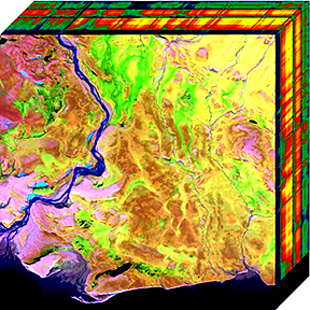
Hyperspectral imaging collects and processes information from across the electromagnetic spectrum. The goal of hyperspectral imaging is to obtain the spectrum for each pixel in the image of a scene, with the purpose of finding objects, identifying materials, or detecting processes. There are three general types of spectral imagers. There are push broom scanners and the related whisk broom scanners, which read images over time, band sequential scanners, which acquire images of an area at different wavelengths, and snapshot hyperspectral imagers, which uses a staring array to generate an image in an instant.

An imaging spectrometer is an instrument used in hyperspectral imaging and imaging spectroscopy to acquire a spectrally-resolved image of an object or scene, often referred to as a datacube due to the three-dimensional representation of the data. Two axes of the image correspond to vertical and horizontal distance and the third to wavelength. The principle of operation is the same as that of the simple spectrometer, but special care is taken to avoid optical aberrations for better image quality.
Chemical imaging is the analytical capability to create a visual image of components distribution from simultaneous measurement of spectra and spatial, time information. Hyperspectral imaging measures contiguous spectral bands, as opposed to multispectral imaging which measures spaced spectral bands.
Electro-optical MASINT is a subdiscipline of Measurement and Signature Intelligence, (MASINT) and refers to intelligence gathering activities which bring together disparate elements that do not fit within the definitions of Signals Intelligence (SIGINT), Imagery Intelligence (IMINT), or Human Intelligence (HUMINT).

The visible and near-infrared (VNIR) portion of the electromagnetic spectrum has wavelengths between approximately 400 and 1100 nanometers (nm). It combines the full visible spectrum with an adjacent portion of the infrared spectrum up to the water absorption band between 1400 and 1500 nm. Some definitions also include the short-wavelength infrared band from 1400 nm up to the water absorption band at 2500 nm. VNIR multi-spectral image cameras have wide applications in remote sensing and imaging spectroscopy. Hyperspectral Imaging Satellite carried two payloads, among which one was working on the spectral range of VNIR.

ADEOS I was an Earth observation satellite launched by NASDA in 1996. The mission's Japanese name, Midori means "green". The mission ended in July 1997 after the satellite sustained structural damage to the solar panel. Its successor, ADEOS II, was launched in 2002. Like the first mission, it ended after less than a year, also following solar panel malfunctions.

Snapshot hyperspectral imaging is a method for capturing hyperspectral images during a single integration time of a detector array. No scanning is involved with this method, in contrast to push broom and whisk broom scanning techniques. The lack of moving parts means that motion artifacts should be avoided. This instrument typically features detector arrays with a high number of pixels.
This is a list of infrared topics.

NOAA-21, designated JPSS-2 prior to launch, is the second of the United States National Oceanic and Atmospheric Administration (NOAA)'s latest generation of U.S. polar-orbiting, non-geosynchronous, environmental satellites called the Joint Polar Satellite System. NOAA-21 was launched on 10 November 2022 and join NOAA-20 and Suomi NPP in the same orbit. Circling the Earth from pole-to-pole, it will cross the equator about 14 times daily, providing full global coverage twice a day. It was launched with LOFTID.

The Martian Moons eXploration (MMX) is a robotic space probe set for launch in 2024 to bring back the first samples from Mars' largest moon Phobos. Developed by the Japanese Aerospace Exploration Agency (JAXA) and announced on 9 June 2015, MMX will land and collect samples from Phobos once or twice, along with conducting Deimos flyby observations and monitoring Mars's climate.

NOAA-20, designated JPSS-1 prior to launch, is the first of the United States National Oceanic and Atmospheric Administration's latest generation of U.S. polar-orbiting, non-geosynchronous, environmental satellites called the Joint Polar Satellite System. NOAA-20 was launched on 18 November 2017 and joined the Suomi National Polar-orbiting Partnership satellite in the same orbit. NOAA-20 operates about 50 minutes behind Suomi NPP, allowing important overlap in observational coverage. Circling the Earth from pole-to-pole, it crosses the equator about 14 times daily, providing full global coverage twice a day. This gives meteorologists information on "atmospheric temperature and moisture, clouds, sea-surface temperature, ocean color, sea ice cover, volcanic ash, and fire detection" so as to enhance weather forecasting including hurricane tracking, post-hurricane recovery by detailing storm damage and mapping of power outages.

MicrOmega-IR is an infrared hyperspectral microscope that is part of the science payload on board the European Rosalind Franklin rover, tasked to search for biosignatures on Mars. The rover is planned to land on Mars in the mid- or late 2020s. MicrOmega-IR will analyse in situ the powder material derived from crushed samples collected by the rover's core drill.
References
- ↑ Frost&Sullivan, Technical Insights, Aerospace&Defence (Feb 2011), #5: World First Thermal Hyperspectral Camera for Unmanned Aerial Vehicles.