The River Glen is a river in Lincolnshire, England with a short stretch passing through Rutland near Essendine.

South Kesteven is a local government district in Lincolnshire, England, forming part of the traditional Kesteven division of the county. Its council is based in Grantham. The district also includes the towns of Bourne, Market Deeping and Stamford, along with numerous villages and surrounding rural areas.
Marston is a village and civil parish in the South Kesteven district of Lincolnshire, England. The population of the civil parish at the 2011 census was 360. It lies 5 miles (8 km) north from Grantham, 8 miles (13 km) south-east from Newark, and 1.5 miles (2.4 km) north from the A1 near Long Bennington

Kates Bridge is a landmark settlement on the A15 road, in the parish of Thurlby. It is approximately 3 miles (5 km) south from Bourne, Lincolnshire, England. Today, Kates Bridge consists of little more than three bridges, a petrol filling station, tractor dealership, five houses, and a farm.
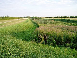
The Car Dyke was, and to a large extent still is, a long ditch which runs along the western edge of the Fens in eastern England for a distance of over 57 miles (92 km). It is generally accepted as being of Roman age and, for many centuries, to have been taken as marking the western edge of the Fens. The name derives from carr, a fourteenth-century word for marsh or drained land.

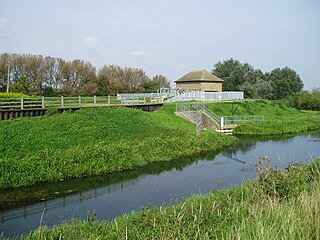
Bourne Eau is a short river which rises from an artesian spring in the town of Bourne in Lincolnshire, England, and flows in an easterly direction to join the River Glen at Tongue End. Within the town, it once powered three water mills, one of which is now a heritage centre. At Eastgate, it becomes much wider as it was navigable in the 18th and 19th centuries, and this was the location of the terminal basin. Below the town it is an embanked river, as its normal level is higher than that of the surrounding Fens. Navigation ceased in the 1860s and the river now forms an important part of the drainage system that enables the surrounding fen land to be used for agriculture.

Grantham and Stamford is a constituency in Lincolnshire represented in the House of Commons of the UK Parliament since 2019 by Gareth Davies, a Conservative.

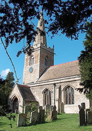
Baston is a village and parish on the edge of The Fens and in the administrative district of South Kesteven, Lincolnshire, England. The 2011 census reported the parish had 1,469 people in 555 households.

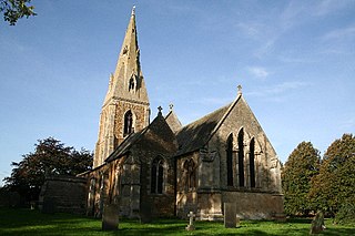
Thurlby is a village and civil parish in the South Kesteven district of Lincolnshire, England. It is situated just west of the A15 road, 2 miles (3 km) south from the town of Bourne, and on the edge of the Lincolnshire Fens. It is sometimes referred to as Thurlby by Bourne to distinguish it from other villages in Lincolnshire with the same name. Thurlby and the hamlet of Northorpe to its north are conjoined. The parish had a population of 2,136 at the 2001 census and 2,153 at the 2011 census.

Stretham is a village and civil parish 4 miles (6 km) south-south-west of Ely in Cambridgeshire, England, about 74 miles (119 km) by road from London. Its main attraction is Stretham Old Engine, a steam-powered pump used to drain the fens. The pump is still in use today although converted to electric power. It has open days throughout the year.

Greatford is a village and civil parish in the South Kesteven district of Lincolnshire, England. It is situated 2 miles (3 km) west from the A15, 4.5 miles (7 km) north-east from Stamford, and 5 miles (8 km) south from Bourne. Greatford is noted for Greatford Hall, once the home of Francis Willis.
Edenham is a village and civil parish in the South Kesteven district of Lincolnshire, England. It is approximately 3 miles (5 km) north-west of Bourne, and on the A151 road. While the civil parish is called 'Edenham', the parish council is called Edenham, Grimsthorpe, Elsthorpe & Scottlethorpe Parish Council. The population of the civil parish at the 2011 census was 291.
Little Bytham is a village and civil parish in the South Kesteven district of Lincolnshire, England. The population of the civil parish at the 2011 census was 384. It lies on the B1176 road, 4 miles (6 km) south from Corby Glen and 6 miles (10 km) north from Stamford.
Tongue End is a small village in the South Holland district of Lincolnshire, England. It is situated 4 miles (6 km) east from Bourne and 6 miles (10 km) south-west from Spalding, and alongside the Counter Drain that runs between Baston and Pode Hole.

Holy Sepulchre Church was a medieval monastic house in Thetford, Norfolk. The ruined nave of this 14th-century church are the only surviving remains in England of a priory of Canons of the Holy Sepulchre, who followed the Rule of Saint Augustine and aided pilgrims to Christ's tomb. It was later used as a barn, and is a Grade I listed building.

Tumby is a village in the East Lindsey district of Lincolnshire, England. It is situated approximately 2 miles (3.2 km) north from Coningsby and 6.5 miles (10.5 km) south from Horncastle, and in the civil parish of Kirkby on Bain.
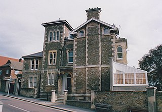
Baston Lodge is a residential villa in St Leonards-on-Sea, Hastings, East Sussex, southern England.

Willow Tree Fen is a local nature reserve with an area of over 112.0 ha located near Bourne and Spalding, south of the River Glen, England. The site was acquired by Lincolnshire Wildlife Trust in 2009 and converted from an arable field into a wetland fen.

