
Montana is a state in the Mountain region of the Western United States. It is bordered by Idaho to the west, North Dakota and South Dakota to the east, Wyoming to the south, and the Canadian provinces of Alberta, British Columbia, and Saskatchewan to the north. It is the fourth-largest state by area, the eighth-least populous state, and the third-least densely populated state. Its capital is Helena, while the largest city is Billings. The western half of the state contains numerous mountain ranges, while the eastern half is characterized by western prairie terrain and badlands, with smaller mountain ranges found throughout the state.
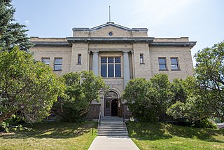
Granite County is a county located in the U.S. state of Montana. As of the 2020 census, the population was 3,309. Its county seat is Philipsburg. The county was founded in 1893, and was named for a mountain which contains the Granite Mountain silver mine.

U.S. Route 2 or U.S. Highway 2 (US 2) is an east–west United States Numbered Highway spanning 2,571 miles (4,138 km) across the northern continental United States. US 2 consists of two segments connected by various roadways in southern Canada. Unlike some routes, which are disconnected into segments because of encroaching Interstate Highways, the two portions of US 2 were designed to be separate in the original 1926 highway plan.

State Route 542 (SR 542) is a 57.24-mile-long (92.12 km) state highway in the U.S. state of Washington, serving Mount Baker in Whatcom County. SR 542 travels east as the Mount Baker Highway from an interchange with Interstate 5 (I-5) in Bellingham through the Nooksack River valley to the Mt. Baker Ski Area at Austin Pass. It serves as the main highway to Mount Baker and the communities of Deming, Kendall, and Maple Falls along the Nooksack River. The highway was constructed in 1893 by Whatcom County as a wagon road between Bellingham and Maple Falls and was added to the state highway system as a branch of State Road 1 in 1925. The branch was transferred to Primary State Highway 1 (PSH 1) during its creation in 1937 and became SR 542 during the 1964 highway renumbering.

Absaroka–Beartooth Wilderness was created from existing National Forest lands in 1978 and is located in Montana and Wyoming, United States. The wilderness is partly in Gallatin, Custer and Shoshone National Forests and is composed of 944,000 acres (3,820 km2). The wilderness encompasses two distinct mountain ranges, namely the Beartooth and Absaroka ranges. These ranges are completely distinct geologically speaking with the Absarokas composed primarily of volcanic and metamorphic rock, while the Beartooths are made up almost entirely of granitic rocks. The Absarokas are noted for their dark and craggy appearance, lush and heavily forested valleys and abundant wildlife. The highest peak in the range, located in Wyoming, is Francs Peak at 13,153 feet (4,009 m). The Beartooths are more alpine with huge treeless plateaus and the highest peak in the state of Montana. The wilderness contains 30 peaks over 12,000 feet (3,700 m). The wilderness is an integral part of the 20-million-acre (81,000 km2) Greater Yellowstone Ecosystem and borders Yellowstone National Park.
The Cabinet Mountains Wilderness, created by an act of Congress in 1964, is located in the U.S. state of Montana. Protecting the wildest portions of the Cabinet Mountains and an integral part of Kootenai National Forest and Kaniksu National Forest, the wilderness had enjoyed more limited protection since 1935 as a Primitive Area.
Colonel Bob Wilderness is a 11,855-acre (4,798 ha) protected area located in the southwest corner of Olympic National Forest in the state of Washington. It is named after 19th-century orator Robert Green Ingersoll. Lake Quinault lies about 15 miles to the west. Elevations in the wilderness vary from 300 to 4,509 feet above sea level. The highest elevation is an unnamed peak; the second-highest elevation is Colonel Bob Mountain at 4,492 feet. The wilderness is a temperate rain forest with annual rainfall greater than 150 inches (3,800 mm).

Buck Meadows is a census-designated place in Mariposa County, California, United States. It is located 2 miles (3 km) east-northeast of Smith Peak, at an elevation of 3,015 feet (919 m). The population was 21 at the 2020 census.
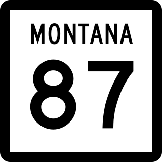
Montana Highway 87 (MT 87) is a primary state highway in Madison County in Montana, United States. The highway travels through mainly rural areas in Raynolds Pass, from the Montana–Idaho state line to an intersection with U.S. Route 287 (US 287). The route travels through a portion of Gallatin National Forest. In 1922, a road in the location of MT 87 was added to the highway system, and a few years later the road was designated as portions of two early auto trails. In 1959, the route was rapidly improved due to the collapse of US 287 nearby. During 1967, much of the highway was reconstructed along its current location.

Petroleum County is a county in the U.S. state of Montana. As of the 2020 census, the population was 496, making it the least populous county in Montana and the eighth-least populous in the United States. Its county seat is Winnett. The county's area was partitioned from Fergus County in 1925 to become the last of Montana's 56 counties to be organized.

U.S. Route 20 is a transcontinental east–west U.S. Highway that travels between Newport, Oregon, and Boston, Massachusetts. It passes through southern Montana for approximately 10 miles (16 km), connecting Targhee Pass at the Idaho state line to the town of West Yellowstone and the West Entrance of Yellowstone National Park near the Wyoming border.
The 2020 Central Idaho earthquake occurred in the western United States on March 31, 2020, at 5:52 PM MDT, near Ruffneck Peak in the Sawtooth Mountains of central Idaho, 72 miles (116 km) northeast of Boise and 19 miles (31 km) northwest of Stanley. It had a magnitude of 6.5 and was felt with a maximum intensity of VIII.

Stillwater State Forest is a state forest located in Montana. The forest has an area of approximately 90,000 acres and is one of the seven state forests in Montana.
Swan River State Forest is a state forest located in Montana. The forest has an area of approximately 39,000 acres and is one of the seven state forests in Montana.
Coal Creek State Forest is a state forest located in Montana. The forest has an area of approximately 20,000 acres and is one of the seven state forests in Montana.
Sula State Forest is a state forest located in Montana. The forest has an area of approximately 10,000 acres and is one of the seven state forests in Montana.
Clearwater State Forest is a state forest located in Montana. The forest has an area of approximately 18,076 acres and is one of the seven state forests in Montana.
Lincoln State Forest is a state forest located in Montana. The forest has an area of approximately 8,245 acres and is one of the seven state forests in Montana.

