
Dawson County is a county located in the U.S. state of Montana. As of the 2020 census, the population was 8,940. Its county seat is Glendive.

Glendive is a city in and the county seat of Dawson County, Montana, United States, and home to Dawson Community College. Glendive was established by the Northern Pacific Railway when they built the transcontinental railroad across the northern tier of the western United States from Minnesota to the Pacific Coast. The town was the headquarters for the Yellowstone Division that encompassed 875 route miles (1,408 km); 546 (879) in main line and 328 (528) in branches with the main routes from Mandan, North Dakota, to Billings, Montana, and from Billings to Livingston. The town of Glendive is an agricultural and ranching hub of eastern Montana sited between the Yellowstone River and the Badlands. Makoshika State Park is located just east of Glendive.
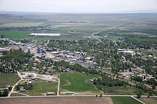
Choteau is a city in and the county seat of Teton County, Montana, United States. The population was 1,721 at the 2020 census.

Badlands are a type of dry terrain where softer sedimentary rocks and clay-rich soils have been extensively eroded. They are characterized by steep slopes, minimal vegetation, lack of a substantial regolith, and high drainage density. Ravines, gullies, buttes, hoodoos and other such geologic forms are common in badlands.
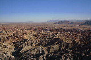
Anza-Borrego Desert State Park is a California State Park located within the Colorado Desert of southern California, United States. The park takes its name from 18th century Spanish explorer Juan Bautista de Anza and borrego, a Spanish word for sheep. With 585,930 acres (237,120 ha) that includes one-fifth of San Diego County, it is the largest state park in California and the second biggest park nationally.
The Charles M. Russell National Wildlife Refuge is a National Wildlife Refuge in the U.S. state of Montana on the Missouri River. The refuge surrounds Fort Peck Reservoir and is 915,814 acres (3,706.17 km2) in size. It is the second-largest National Wildlife Refuge in the lower 48 states of the United States, and the largest in Montana. Created in 1936, it was originally called the Fort Peck Game Range. It was renamed in 1963 after Montana artist Charles M. Russell, a famous painter of the American West. In 1976, the "range" was made a "refuge".
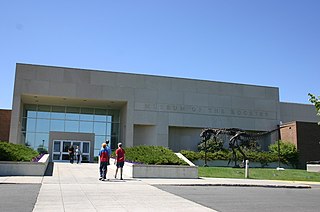
Museum of the Rockies is a museum in Bozeman, Montana. Originally affiliated with Montana State University in Bozeman, and now also, the Smithsonian Institution. The museum is largely known for its Paleontological collections as well as having the largest collection of North American Dinosaur fossils in the United States. They also possess the largest Tyrannosaurus skull ever discovered, as well as the thigh bone of a Tyrannosaurus Rex that contains soft-tissue remains. The museum is part of the Montana Dinosaur Trail and is Montana's official repository for Paleontological specimens.
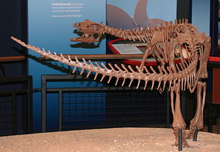
Thescelosaurus was a genus of small neornithischian dinosaur that appeared at the very end of the Late Cretaceous period in North America. It was a member of the last dinosaurian fauna before the Cretaceous–Paleogene extinction event around 66 million years ago. The preservation and completeness of many of its specimens indicate that it may have preferred to live near streams.

Pictograph Cave is an area of three caves located 5 miles (8.0 km) south of Billings, Montana, United States, preserved and protected in the 23-acre (9.3 ha) Pictograph Cave State Park.

The Hell Creek Formation is an intensively studied division of mostly Upper Cretaceous and some lower Paleocene rocks in North America, named for exposures studied along Hell Creek, near Jordan, Montana. The formation stretches over portions of Montana, North Dakota, South Dakota, and Wyoming. In Montana, the Hell Creek Formation overlies the Fox Hills Formation. The site of Pompeys Pillar National Monument is a small isolated section of the Hell Creek Formation. In 1966, the Hell Creek Fossil Area was designated as a National Natural Landmark by the National Park Service.

Montana is one of the eight Mountain States, located in the north of the region known as the Western United States. It borders North Dakota and South Dakota to the east. Wyoming is to the south, Idaho is to the west and southwest, and the Canadian provinces of British Columbia, Alberta, and Saskatchewan are to the north, making it the only state to border three Canadian provinces.
The Makoshika Dinosaur Museum was a private, non-profit regional museum located in Glendive, eastern Montana, United States. It opened in 2004, and before its closure, attracted between 1,500 and 2,000 visitors each summer. It was housed in a building dating from the 1900s and presented dinosaur casts/sculptures and fossils from around the world. It has since been reported closed.

Titanoceratops is a controversial genus of herbivorous ceratopsian dinosaur. It was a giant chasmosaurine ceratopsian that lived in the Late Cretaceous period in what is now New Mexico. Titanoceratops was named for its large size, being one of the largest known horned dinosaurs and the type species was named T. ouranos, after Uranus (Ouranos), the father of the Greek titans. It was named in 2011 by Nicholas R. Longrich for a specimen previously referred to Pentaceratops. Longrich believed that unique features found in the skull reveal it to have been a close relative of Triceratops, classified within the subgroup Triceratopsini. However, other researchers have expressed skepticism, and believe "Titanoceratops" to simply be an unusually large, old specimen of Pentaceratops.

First Peoples Buffalo Jump State Park is a Montana state park and National Historic Landmark in Cascade County, Montana in the United States. The park is 1,481 acres (599 ha) and sits at an elevation of 3,773 feet (1,150 m). It is located about 3.5 miles (5.6 km) northwest of the small town of Ulm, which is near the city of Great Falls. First Peoples Buffalo Jump State Park contains the Ulm Pishkun, a historic buffalo jump utilized by the Native American tribes of North America. It has been described as, geographically speaking, either North America's largest buffalo jump or the world's largest. There is some evidence that it was the most utilized buffalo jump in the world. The site was added to the National Register of Historic Places on December 17, 1974, and designated a National Historic Landmark in August 2015. The former name of the park was derived from the Blackfeet word "Pis'kun," meaning "deep kettle of blood," and the nearby town of Ulm.
Paleontology in North Dakota refers to paleontological research occurring within or conducted by people from the U.S. state of North Dakota. During the early Paleozoic era most of North Dakota was covered by a sea home to brachiopods, corals, and fishes. The sea briefly left during the Silurian, but soon returned, until once more starting to withdraw during the Permian. By the Triassic some areas of the state were still under shallow seawater, but others were dry and hot. During the Jurassic subtropical forests covered the state. North Dakota was always at least partially under seawater during the Cretaceous. On land Sequoia grew. Later in the Cenozoic the local seas dried up and were replaced by subtropical swamps. Climate gradually cooled until the Ice Age, when glaciers entered the area and mammoths and mastodons roamed the local woodlands.
Paleontology in Montana refers to paleontological research occurring within or conducted by people from the U.S. state of Montana. The fossil record in Montana stretches all the way back to the Precambrian. During the Late Precambrian, western Montana was covered by a warm, shallow sea where local bacteria formed stromatolites and bottom-dwelling marine life left tracks on the sediment that would later fossilize. This sea remained in place during the early Paleozoic, although withdrew during the Silurian and Early Devonian, leaving a gap in the local rock record until its return. This sea was home to creatures including brachiopods, conodonts, crinoids, fish, and trilobites. During the Carboniferous the state was home to an unusual cartilaginous fish fauna. Later in the Paleozoic the sea began to withdraw, but with a brief return during the Permian.

Paleontology in the United States refers to paleontological research occurring within or conducted by people from the United States. Paleontologists have found that at the start of the Paleozoic era, what is now "North" America was actually in the southern hemisphere. Marine life flourished in the country's many seas. Later the seas were largely replaced by swamps, home to amphibians and early reptiles. When the continents had assembled into Pangaea drier conditions prevailed. The evolutionary precursors to mammals dominated the country until a mass extinction event ended their reign.

The Glendive Dinosaur and Fossil Museum is a private dinosaur museum in Glendive, Montana, in the United States. The museum was founded by Otis Kline, and is owned by the non-profit organization Advancing Creation Truth. It promotes a Young Earth creationist (YEC) explanation of evolution based on a literal interpretation of the Genesis creation narrative in the Bible. This creationist museum promotes the belief that dinosaurs and humans lived at the same time, including a belief that dinosaurs were on Noah's ark. Built between 2005 and 2009, mostly with volunteer labor, the structure is valued at about $4 million, not counting the value of the exhibits.


