Marr is one of six committee areas in Aberdeenshire, Scotland. It has a population of 34,038. Someone from Marr is called a Màrnach in Scottish Gaelic.

The Alford Valley Railway is a 2 ft narrow gauge railway in the Howe of Alford, Aberdeenshire, Scotland. It is located at what used to be the terminus of the passenger and goods Alford Valley Railway which connected with the Great North of Scotland Railway main line at Kintore.

Aberdeenshire or the County of Aberdeen is a historic county and registration county of Scotland. The area of the county, excluding the city of Aberdeen itself, is also a lieutenancy area. The county borders Kincardineshire, Angus and Perthshire to the south, Inverness-shire and Banffshire to the west, and the North Sea to the north and east. It has a coast-line of 65 miles (105 km).

Alford is a large village in Aberdeenshire, north-east Scotland, lying just south of the River Don. It lies within the Howe of Alford which occupies the middle reaches of the River Don.

Kintore is a town and former royal burgh near Inverurie in Aberdeenshire, Scotland, now bypassed by the A96 road between Aberdeen and Inverness. It is situated on the banks of the River Don.

West Aberdeenshire and Kincardine is a county constituency of the House of Commons of the Parliament of the United Kingdom of Great Britain and Northern Ireland (Westminster), which elects one Member of Parliament (MP) by the first past the post system of election. It was first used in the 1997 general election, but has undergone boundary changes since that date.

The name Bullers of Buchan refers both to a collapsed sea cave and to the adjacent village, situated about 6 miles (9.7 km) south of Peterhead in Buchan, Aberdeenshire, Scotland.

Grampian Transport Museum is a transport museum and charitable-based trust located in Alford, Aberdeenshire, Scotland. Its exhibits chart the history of transport in the north east of Scotland through dramatic displays, working and climb-aboard vehicle exhibits and video presentations.

Blackburn is a rapidly growing village northwest of Aberdeen, Scotland, and is situated in Aberdeenshire. Local amenities include an industrial estate, primary school, nursing home, post office, Starbucks Drive Thru, local Co-op and a community hall.

Blondins were a type of material ropeway; they were named after the famous tightrope walker Charles Blondin.

Lumsden is an inland village in Aberdeenshire, Scotland on the A97 road.
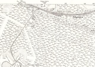
Tillyfourie railway station was a railway station serving Tillyfourie, Aberdeenshire, Scotland.
This is a list of the extreme points and extreme elevations in Scotland.

The Gordon Way is a waymarked hiking trail in Aberdeenshire, Scotland. It runs for 11+1⁄2 miles (18.5 km) through the Bennachie Forest. The route was one of a series maintained by the Forestry Commission and Aberdeenshire Council. In 2016, the council withdrew completely from its maintaining the route due to budgetary constraints.
Keig is a village within the local government area of Aberdeenshire Council in the North East of Scotland and is located within the Marr area of Aberdeenshire three miles from Alford. It lies on the B992 road between Insch and the village of Whitehouse.
The Alford Valley Railway was a railway company that built a branch line in Scotland, connecting Alford and Kintore on the main line of the Great North of Scotland Railway (GNoSR), giving access to Aberdeen. The line was opened in 1859. It struggled financially from the outset, and it was only support from the GNoSR that enabled it to continue. The GNoSR absorbed it in 1866.
Mossat is a settlement in Aberdeenshire, Scotland on the A97 road near Glenkindie and Lumsden, between Bridge of Alford and Strathdon, and is situated on the Mossat Burn. Mossat has a garden centre, cafe and antique shop.

Bridge of Alford is a village in Aberdeenshire, Scotland.
The Aberdeenshire Amateur Football Association (AAFA) is the governing body for amateur football in the City of Aberdeen and County of Aberdeenshire in North East Scotland. They run the Aberdeenshire Amateur Football League and associated cup competitions. The association was founded in 1947 and is affiliated to the Scottish Amateur Football Association.
Whitehouse is a hamlet in Aberdeenshire, Scotland. It is located on the A944 road 2 miles southeast of Alford.