Tivetshall railway station

Last updated

Tivetshall
Tivetshall station.jpg
General information
Location Tivetshall St Margaret, District of South Norfolk
England
Grid reference TM157879
Platforms3
Other information
StatusDisused
History
Pre-grouping Eastern Union Railway
Great Eastern Railway
Post-grouping London and North Eastern Railway
Eastern Region of British Railways
Key dates
12 December 1849Opened
18 April 1966Closed to freight
7 November 1966Closed to passengers

Tivetshall was a railway station on the Great Eastern Main Line located in Tivetshall, Norfolk. It was also the western terminus of the Waveney Valley Line from Beccles. It served six small parishes in an agricultural area.

Contents

History

Design and opening

It was first opened when Norwich and London were connected by the Eastern Union Railway in 1849. The EUR was taken over by the Eastern Counties Railway before becoming the Great Eastern Railway in 1862. The station building, located on the down side of the main line, was believed to have been designed by Frederick Barnes (architect) who was responsible for designing a number of other stations at this time in East Anglia. [1]

19th century

In 1855, the Waveney Valley Line was opened as far as Harleston; it was extended to Bungay in 1860 and finally on to Beccles.

A new signal box was provided in 1880 and this lasted 106 years. Immediately south of the station was a level crossing, which spanned all three tracks (the two main lines and platform road for the Waveney Valley line). A small goods yard was provided north of the station on the down side of the line and a small maltings (operated by Watney Combe & Reid in the 1960s) was also served by rail. [2]

In the 1880s, there were four main line trains each way serving Tivetshall and five trains serving the Waveney Valley line. In 1881, the GER built a timber waiting room on the up side of the station. [3]

Water troughs were installed near Tivetshall station in 1896, [4] which allowed trains to pick up water without stopping. [5] These were taken out of service in 1945, but the station had three water cranes. [6]

20th century

On 31 August 1907, Arthur Hardiment attempted to save an 18 month old toddler from an oncoming express train. The toddler got clear, but Hardiment was struck by the engine suffering injury as a result. For this action, he was awarded the Albert Medal Second Class for gallantry receiving his award at Windsor Castle from King Edward VII on 13 November the same year. [7]

In 1923, the operation of Tivetshall station was taken over by the London and North Eastern Railway. Some additional sidings were added during the Second World War for traffic to local airfields. [8]

Following nationalisation in 1948, the station became part of the Eastern Region of British Railways.

In the early 1950s, there were eight main-line trains each way serving Tivetshall and seven trains serving the Waveney Valley line.

Decline and closure

Passenger services on the Waveney Valley line ceased in 1953; goods services continued on the line until 1966.

Station site in 2009. Tivetshall Railway.jpg
Station site in 2009.

1966 also saw an end to the local main line freight services in April and, with the withdrawal of the local Ipswich to Norwich passenger service, the station closed on 7 November. [9]

The signal box survived for a further twenty years but, following resignalling and electrification of the line, this closed. At this time, the remaining station buildings were demolished although the goods shed was still extant in 1994. [10]

Former services

Preceding station Disused railways Following station
Forncett   Great Eastern Railway
Great Eastern Main Line
  Burston
Terminus  Great Eastern Railway
Waveney Valley Line
  Pulham Market

Related Research Articles

<span class="mw-page-title-main">Beccles</span> Human settlement in England

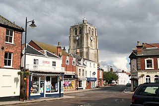
Beccles is a market town and civil parish in the English county of Suffolk. The town is shown on the milestone as 109 miles (175 km) from London via the A145 and A12 roads, 98 miles (158 km) north-east of London as the crow flies, 16 miles (26 km) south-east of Norwich and 33 miles (53 km) north-northeast of the county town of Ipswich. Nearby towns include Lowestoft to the east and Great Yarmouth to the north-east. The town lies on the River Waveney on the edge of The Broads National Park.

<span class="mw-page-title-main">Lowestoft railway station</span> Railway Station in Suffolk, England

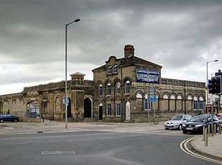
Lowestoft railway station serves the town of Lowestoft, Suffolk, and is the eastern terminus of the East Suffolk Line from Ipswich and is one of two eastern termini of the Wherry Lines from Norwich. Lowestoft is 23 miles 41 chains (37.8 km) down the line from Norwich and 48 miles 75 chains (78.8 km) measured from Ipswich; and is the easternmost station on the National Rail network in the United Kingdom.

<span class="mw-page-title-main">Beccles railway station</span> Railway station in Suffolk, England

Beccles railway station is on the East Suffolk Line in the east of England, serving the town of Beccles, Suffolk. It is 40 miles 34 chains (65.1 km) down the line from Ipswich and 109 miles 11 chains (175.6 km) measured from London Liverpool Street; it is situated between Brampton and Oulton Broad South stations. Its three-letter station code is BCC.

<span class="mw-page-title-main">Ellingham, Norfolk</span> Human settlement in England

Ellingham is a civil parish in Norfolk, England. It covers an area of 5.61 km2 (2.17 sq mi) and had a population of 532 in 238 households at the 2001 census, the population increasing to 554 in 248 households at the 2011 census. It lies approximately 2 miles (3.2 km) from Bungay and 4 miles (6.4 km) from Beccles. Within 17 miles (27 km) are Norwich, Diss and, on the North Sea coast, with associated beaches and port, Great Yarmouth. A large percentage of the housing and human population is in the east, Kirby Row the largest nucleated village, which is shared with Kirby Cane, the civil parish to the east.

<span class="mw-page-title-main">Diss railway station</span> Railway station in Norfolk, England

Diss railway station is on the Great Eastern Main Line in the East of England, serving the town of Diss, Norfolk. It is 94 miles 43 chains (152.1 km) down the line from London Liverpool Street and is situated between Stowmarket to the south and Norwich to the north. It is approximately 20 miles (32 km) south of Norwich. Its three-letter station code is DIS.

<span class="mw-page-title-main">Waveney Valley line</span>

The Waveney Valley line was a branch line running from Tivetshall in Norfolk to Beccles in Suffolk connecting the Great Eastern Main Line at Tivetshall with the East Suffolk line at Beccles. It provided services to Norwich, Great Yarmouth, Lowestoft, Ipswich and many other smaller towns in Suffolk with additional services to London. It was named after the River Waveney which follows a similar route.

<span class="mw-page-title-main">Bungay railway station</span> Disused railway station in England

Bungay railway station was located on the now disused Waveney Valley Line which ran between Tivetshall and Beccles. The station was closed in 1953 and the buildings eventually demolished to make way for the A143 road. It was one of two stations in Suffolk on the line, which curved across the county boundary then back into Norfolk.

<span class="mw-page-title-main">Lowestoft North railway station</span> Railway station in Lowestoft, England

Lowestoft North railway station was in Lowestoft, England. It closed in 1970.

<span class="mw-page-title-main">Pulham Market railway station</span> Disused railway station in Norfolk, England

Pulham Market was a railway station on the Waveney Valley Line in Norfolk, England. It was closed for passengers in 1953.

<span class="mw-page-title-main">Pulham St Mary railway station</span> Disused railway station in Norfolk, England

Pulham St Mary was a station in Pulham St Mary, Norfolk on the Waveney Valley Line which is now closed. The station has been demolished.

<span class="mw-page-title-main">Harleston railway station</span> Disused railway station in Norfolk, England

Harleston was a railway station in Harleston, Norfolk, on the Waveney Valley Line. It was an early post-war closure; passenger services on this line were withdrawn in 1953 with goods trains lasting until the complete closure of the line in 1966.

<span class="mw-page-title-main">Homersfield railway station</span> Railway station in Suffolk, England

Homersfield was a railway station which served the village of Homersfield in Suffolk, England, although the station was located in Alburgh, across the county boundary in Norfolk. The station was part of the Waveney Valley Line.

<span class="mw-page-title-main">Earsham railway station</span> Former railway station in England

Earsham was a railway station in Earsham, Norfolk, on the Waveney Valley Line, connecting Beccles with the Great Eastern Main Line which opened in 1860, and closed to passengers in 1953, and to goods services in 1960. It was not demolished, but lay derelict for many years before being converted into housing. The platform remains as do many original features.

<span class="mw-page-title-main">Yarmouth South Town railway station</span> Railway station in Great Yarmouth, England, United Kingdom

Yarmouth South Town, sometimes known as Yarmouth Southtown, was a railway station in Great Yarmouth, England, that is now closed. It was one of three major stations in the town, the others being Yarmouth Vauxhall and Yarmouth Beach, of which only Yarmouth Vauxhall now remains.

<span class="mw-page-title-main">Ellingham railway station</span> Former railway station in England

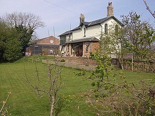
Ellingham is a former railway station in Ellingham, Norfolk. It was opened in 1863 as part of the Waveney Valley Line between Tivetshall and Beccles, Suffolk. It was closed to passengers in 1953 and closed fully on 19 April 1965, when the last goods train called there. The station still stands much altered

<span class="mw-page-title-main">Redenhall railway station</span> Disused railway station in Norfolk, England

Redenhall was a station in the small hamlet of Redenhall, Norfolk. It was opened in 1861 as part of the Waveney Valley Line between Tivetshall and Beccles and closed in 1866. It was close to the settlement of Harleston.

<span class="mw-page-title-main">Ditchingham railway station</span> Former railway station in England

Ditchingham was a railway station in Ditchingham, Norfolk on the Waveney Valley Line. Opened on 2 March 1863, it closed to passengers along with the rest of the line in 1953.

<span class="mw-page-title-main">Geldeston railway station</span> Railway station in Geldeston, the UK

Geldeston was a station in Geldeston, Norfolk – a station on the Waveney Valley Line. It was opened in the early 1860s, and closed to passengers nearly a century later in 1953. It was the penultimate station on the line, and the last in Norfolk as the line crossed the border into Suffolk before the junction station of Beccles. The station still exists today and can easily be found in Geldeston.

Wortwell was a station in the small hamlet of Wortwell, Norfolk. It was opened in 1855, as part of the Waveney Valley Line between Tivetshall and Beccles, and closed in 1878.

The East Suffolk line is a railway in East Anglia with a long history.

References

  1. King, Bill (July 2017). "A brave act at Tivetshall". Great Eastern Journal. 171: 42.
  2. "Spotlight on Tivetshall". Great Eastern Journal. 180: 42. October 2019.
  3. "Spotlight on Tivetshall". Great Eastern Journal. 180: 42. October 2019.
  4. Challis, David; L Brooks; J Watling (July 2013). "Photographing passenger trains in the Stratford area". Great Eastern Railway Journal. 155: 42.
  5. Pember, Geoff (January 1990). "Water troughs of the Great Eastern Railway". Great Eastern Journal. 61: 19.
  6. Kenworthy, Graham (October 1994). "Tivetshall, Norfolk". Great Eastern Journal. 80: 7.
  7. King, Bill (July 2017). "A brave act at Tivetshall". Great Eastern Journal. 171: 42.
  8. King, Bill (July 2017). "A brave act at Tivetshall". Great Eastern Journal. 171: 42.
  9. "Spotlight on Tivetshall". Great Eastern Journal. 180: 42, 43. October 2019.
  10. Kenworthy, Graham (October 1994). "Tivetshall, Norfolk". Great Eastern Journal. 80: 7.

Coordinates: 52°26′50″N1°10′29″E / 52.4472°N 1.1747°E / 52.4472; 1.1747