Trafford Town Hall

Last updated

Trafford Town Hall
Trafford-town-hall3.jpg
Trafford Town Hall
Former namesStretford Town Hall
General information
StatusGrade II Listed Building
TypeTown Hall
Architectural style Neo-Classical
Classification
Listed Building – Grade II
Designated27 March 2007
Reference no. 1391923
AddressTalbot Rd, Stretford, Manchester M32 0TH
CountryEngland
Coordinates 53°27′31″N2°17′15″W / 53.4587°N 2.2876°W / 53.4587; -2.2876 Coordinates: 53°27′31″N2°17′15″W / 53.4587°N 2.2876°W / 53.4587; -2.2876
Current tenantsTrafford Borough Council
Construction started21 August 1931
Inaugurated16 September 1933;89 years ago (1933-09-16)
Cost£88,000 (equivalent of £5,888,578 as of 2018)
Owner Trafford Council
Design and construction
Architect(s) Bradshaw Gass & Hope
Website
https://www.trafford.gov.uk

Trafford Town Hall is a neo-classical building in Stretford, Trafford, Greater Manchester, Sngland. It is the meeting place of Trafford Council and was originally known as "Stretford Town Hall". The building faces Emirates Old Trafford to the south and is within 500 metres of Manchester United's Football Ground to the north.

Contents

History

Before the construction of the town hall, the forerunner authority, Stretford Urban District Council, held its meetings in the District Council Offices on Talbot Road in Old Trafford (subsequently known as Trafford Public Hall and now known as the Trafford Hall Hotel). [1]

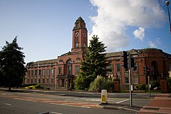
The building now known as Trafford Town Hall stands on a large previously undeveloped site at the junction of Talbot Road and Warwick Road in Stretford, England. [2] It was designed by architects Bradshaw Gass & Hope of Bolton on behalf of Stretford Municipal Borough, and built by the main contractor Edwin Marshall & Sons. [3] Work began on 21 August 1931, [4] funded by a government grant of £88,000 (equivalent to £5.3 million [lower-alpha 1] in 2019); [3] the building was officially opened as Stretford Town Hall on the granting of Stretford's charter on 16 September 1933. [5]

The steel-framed building has two stories plus basement and attic floors, with a mansard roof. Set in landscaped grounds with a sunken garden, it is constructed of brick in Flemish bond with gritstone dressings. It originally consisted of a main front with a wing on each side, until a rear extension was added between the wings in 1983, enclosing an inner courtyard. [3] The building was constructed with a portico with a doric order column and a pillar on either side and a wrought-iron parapet with a circle motif above. [3] The design also included a clock tower which rises in stages. [3] Inside the building, on either side of the central staircase are bronze statues, one of Electra, [6] who was one of the 3,000 Oceanids, and the other of Njörðr, who was the God of wind and sea. [7] [8]

In 1974, on the formation of the Metropolitan Borough of Trafford, the new council adopted the town hall as its base, renaming it Trafford Town Hall. [5] It was renovated in the early 1980s, in a schedule of work that included the addition of a 10,000-square-metre (110,000 sq ft) underground nuclear fall-out shelter; the shelter was subsequently used for storage until its closure in 2011. [9] Trafford Town Hall was designated a Grade II listed building in 2007. [3]

In 2011, the 1983 extension was demolished, and the 1933 original building refurbished, with new offices added. The refurbishment works, which were intended to create an open-plan environment, were designed by 5plus Architects and undertaken by Shepherd Developments. [10] The new buildings were opened in 2013. [11]

See also

Related Research Articles

<span class="mw-page-title-main">Altrincham</span> Town in Greater Manchester, England

Altrincham is a market town in Trafford, Greater Manchester, England, south of the River Mersey. It is 8 miles (13 km) southwest of Manchester city centre, 3 miles (5 km) southwest of Sale and 10 miles (16 km) east of Warrington. At the 2011 Census, it had a population of 52,419.

<span class="mw-page-title-main">Trafford</span> Greater Manchester local authority district

Trafford is a metropolitan borough of Greater Manchester, England, with an estimated population of 235,493 in 2017. It covers 41 square miles (106 km2) and includes the area of Old Trafford and the towns of Altrincham, Stretford, Urmston, Partington and Sale. The borough was formed in 1974 as a merger of six former districts and part of a seventh. The River Mersey flows through the borough, separating North Trafford from South Trafford, and the historic counties of Lancashire and Cheshire. Trafford is the fifth-most populous district in Greater Manchester.

<span class="mw-page-title-main">Sale, Greater Manchester</span> Town in Greater Manchester, England

Sale is a town in Trafford, Greater Manchester, England; historically, it was part of Cheshire until 1974. It is located on the south bank of the River Mersey, 2 miles (3.2 km) south of Stretford, 3 miles (4.8 km) north-east of Altrincham and 5 miles (8.0 km) south-west of Manchester. In 2011, it had a population of 134,022, making it the largest town by population in Trafford.

<span class="mw-page-title-main">Old Trafford</span> Football stadium in Manchester, England

Old Trafford is a football stadium in Old Trafford, Greater Manchester, England, and the home of Manchester United. With a capacity of 74,310 it is the largest club football stadium in the United Kingdom, and the eleventh-largest in Europe. It is about 0.5 miles (800 m) from Old Trafford Cricket Ground and the adjacent tram stop.

<span class="mw-page-title-main">Trafford Centre</span> Shopping mall and entertainment complex in Trafford, Greater Manchester

The Trafford Centre is a large indoor shopping centre and leisure complex in Greater Manchester, England. Located in Urmston in the Metropolitan Borough of Trafford, the centre is within the Trafford Park industrial estate, five miles west of Manchester city centre.

<span class="mw-page-title-main">Stretford</span> Town in Greater Manchester, England

Stretford is a market town in Trafford, Greater Manchester, England. It is situated on flat ground between the River Mersey and the Manchester Ship Canal, 3.8 miles (6.1 km) south of Manchester city centre, 3.0 miles (4.8 km) south of Salford and 4.2 miles (6.8 km) north-east of Altrincham. Stretford borders Chorlton-cum-Hardy to the east, Moss Side and Whalley Range to the south-east, Hulme to the north-east, Urmston to the west, Salford to the north, and Sale to the south. The Bridgewater Canal bisects the town.

<span class="mw-page-title-main">Urmston</span> Town in Greater Manchester, England

Urmston is a town in Trafford, Greater Manchester, England, which had a population of 41,825 at the 2011 Census. Historically in Lancashire, it is 5 miles (8 km) southwest of Manchester city centre. The southern boundary is the River Mersey, with Stretford lying to the east and Flixton to the west. Davyhulme lies to the north of the town centre. Urmston covers an area of 4,799 acres (19 km2).

Clayton is a suburb of Manchester, England, 3 miles east of the city centre on Ashton New Road.

<span class="mw-page-title-main">Stretford and Urmston (UK Parliament constituency)</span> Parliamentary constituency in the United Kingdom, 1997 onwards

Stretford and Urmston is a constituency in Greater Manchester represented in the House of Commons of the UK Parliament since 2010 by Kate Green, a member of the Labour Party.

<span class="mw-page-title-main">Old Trafford (area)</span> Inner city area of Greater Manchester

Old Trafford is an area of Stretford in the Metropolitan Borough of Trafford, Greater Manchester, England. The area borders the adjacent cities of Manchester and Salford and is located two miles (3.2 km) southwest of Manchester city centre. It is roughly delineated by two old toll gates; Brooks's Bar and Trafford Bar, to the east and west.

<span class="mw-page-title-main">Partington</span> Human settlement in England

Partington is a town and civil parish in the Metropolitan Borough of Trafford, Greater Manchester, England, ten miles (16 km) south-west of Manchester city centre. Within the boundaries of the historic county of Cheshire, it lies on the southern bank of the Manchester Ship Canal, opposite Cadishead on the northern bank. It has a population of 7,327.

<span class="mw-page-title-main">Trafford Park</span> Area of Greater Manchester, England

Trafford Park is an area of the Metropolitan Borough of Trafford, Greater Manchester, England, opposite Salford Quays on the southern side of the Manchester Ship Canal, 3.4 miles (5.5 km) southwest of Manchester city centre and 1.3 miles (2.1 km) north of Stretford. Until the late 19th century, it was the ancestral home of the Trafford family, who sold it to financier Ernest Terah Hooley in 1896. Occupying an area of 4.7 square miles (12 km2), it was the first planned industrial estate in the world, and remains the largest in Europe well over a century later.

<span class="mw-page-title-main">Trafford Bar tram stop</span> Manchester Metrolink tram stop

Trafford Bar is a tram stop on Greater Manchester's light rail system, Metrolink, at the junction of Talbot Road and Seymour Grove in Old Trafford. It opened on 15 June 1992 as part of Phase 1 of Metrolink's expansion, before which it was a mainline railway station.

<span class="mw-page-title-main">Trafford College</span> Further education school in Trafford, Greater Manchester, England

Trafford College is a further education college in Trafford, Greater Manchester, England. It was formed with the merger of North Trafford College and South Trafford College in 2007.

<span class="mw-page-title-main">Municipal Borough of Stretford</span>

Stretford was, from 1868 to 1974, a local government district coterminate with the town of Stretford, Lancashire, England.

<span class="mw-page-title-main">Stretford Grammar School</span> Foundation grammar school in Stretford, Greater Manchester, England

Stretford Grammar School is a grammar school located in Stretford, in the Trafford borough of Greater Manchester, England. It is located on a 15-acre plot in the heart of Stretford, Trafford.

Stretford is a town in the Metropolitan Borough of Trafford, Greater Manchester, England. The town contains 20 listed buildings that are recorded in the National Heritage List for England. All the listed buildings are designated at Grade II, the lowest of the three grades, which is applied to "buildings of national importance and special interest". The town is adjacent to the centre of Manchester, and is partly residential and partly industrial. The Bridgewater Canal and the Manchester Ship Canal run through the town, and there are listed buildings associated with both canals. The other listed buildings include two medieval structures, churches, the entrances to a former botanical garden and to a park, a factory, civic buildings, a former cinema, a hotel, and three war memorials.

<span class="mw-page-title-main">Barking Town Hall</span> Municipal building in London, England

Barking Town hall is a municipal building in Clockhouse Avenue, Barking, London. The town hall, which is the headquarters of Barking and Dagenham London Borough Council, is a locally listed building.

<span class="mw-page-title-main">Sale Town Hall</span> Municipal building in Sale, Greater Manchester, England

Sale Town Hall is a municipal building in School Road, Sale, Greater Manchester, England. The town hall was the headquarters of Sale Borough Council until the council was abolished in 1974.

<span class="mw-page-title-main">Altrincham Town Hall</span> Municipal building in Altrincham, Greater Manchester, England

Altrincham Town Hall is a municipal building in Market Street, Altrincham, Greater Manchester, England. The town hall was the headquarters of Altrincham Borough Council.

References

Notes

  1. United Kingdom Gross Domestic Product deflator figures follow the Measuring Worth "consistent series" supplied in Thomas, Ryland; Williamson, Samuel H. (2018), "What Was the U.K. GDP Then?", MeasuringWorth, retrieved 2 February 2020

Citations

  1. "Annual Reports for 1904 of the Medical Officer of Health and Inspector of Nuisances". The Urban District Council of Stretford. 24 February 1905. Retrieved 10 August 2020.
  2. "Trafford Civic Quarter: Area Action Plan: Heritage Assessment" (PDF). 1 November 2019. p. 8. Retrieved 10 August 2020.
  3. 1 2 3 4 5 6 Historic England, "Trafford Town Hall (1391923)", National Heritage List for England , retrieved 13 March 2015
  4. "Stretford Town Hall", Trafford Council, archived from the original on 30 September 2007, retrieved 29 March 2012
  5. 1 2 "Autumn 2007", The Twentieth Century Society, archived from the original on 19 January 2012, retrieved 29 March 2012
  6. "Electra". Art UK. Retrieved 21 September 2021.
  7. Hartwell, Clare; Hyde, Matthew; Pevsner, Nikolaus (2004), Lancashire: Manchester and the South-East, The Buildings of England, New Haven and London: Yale University Press, p. 84, ISBN   0-300-10583-5
  8. "Trafford Town Hall". Manchester History. Retrieved 10 August 2020.
  9. Williams, Jennifer (9 November 2011), "Nuclear bunker that had Trafford Town Hall chiefs at war is uncovered", Manchester Evening News, MEN Media, retrieved 29 March 2012
  10. "Trafford Town Hall". E-Architect. Retrieved 10 August 2020.
  11. Mara, Felix (18 July 2013), "Keep it simple: Trafford Town Hall redevelopment by 5Plus", Architects' Journal, retrieved 13 March 2015

Commons-logo.svg Media related to Trafford Town Hall at Wikimedia Commons