Transport in North Korea is constrained by economic problems and government restrictions. Public transport predominates, and most of it is electrified.
Travel to North Korea is tightly controlled. The standard route to and from North Korea is by plane or train via Beijing. Transport directly to and from South Korea was possible with Vip Family Zone Tour and travel within the cities on a limited scale from 2003 until 2008, when a road was opened (bus tours, no private cars). Freedom of movement in North Korea is also limited,[1] as citizens are not allowed to move around freely inside their country.[2] On October 14, 2018, North and South Korea agreed to restore inter-Korean rail and road transportation.[3] On November 22, 2018, North and South Korea reopened a road on the Korean border which had been closed since 2004.[4][5] On November 30, 2018, inter-Korean rail transportation resumed when a South Korean train crossed into North Korea for the first time since November 2008.[6] On December 8, 2018, a South Korean bus crossed into North Korea.[7][needs update]
Fuel constraints and the near absence of private automobiles have relegated road transportation to a secondary role.[8] The road network was estimated to be around 31,200 kilometres (19,400mi) in 1999, up from between 23,000 kilometres (14,000mi) and 30,000 kilometres (19,000mi) in 1990, of which only 1,717 kilometres (1,067mi), 7.5%, are paved.[citation needed] However, The World Factbook (published by the US Central Intelligence Agency) lists 25,554 kilometres (15,879mi) of roads with only 724 kilometres (450mi) paved as of 2006.[9]
There are three major multilane highways in North Korea: the Pyongyang–Wonsan Tourist Motorway, a 200-kilometre (120mi) expressway connecting Pyongyang and Wonsan on the east coast, the Youth Hero Motorway, a 43-kilometre (27mi) expressway connecting Pyongyang and its port, Nampo, and the Pyongyang-Kaesong Motorway, a four-lane 100-kilometre (62mi) motorway linking Pyongyang and Kaesong. The overwhelming majority of the estimated 264,000 vehicles in use in 1990 were for the military. Rural bus service connects all villages, and all major cities have bus and tram services.[8] Since 1945/1946, there is right-hand traffic on roads.[citation needed] In cities, driving speeds are set by which lane a driver is in.[10] The speed limits are 40 kilometres per hour (25mph), 60 kilometres per hour (37mph), and 70 kilometres per hour (43mph) for the first, second, and subsequent (if existing) lanes from the right, respectively. A white-on-blue sign informs about this.[10] The leftmost lane, if it is number 3 from the right or higher and is not a turning lane, is often left vacant, even by tourist buses, while the second-from-right lane is generally used to overtake vehicles from lane one, such as public transport buses and trams.
Besides the blue in-city sign, all other occasions, such as motorways and roads outside cities, use the more widely known red-circle-with-number-inside sign to post speed limits. On motorways, the typical limit is 80 kilometres per hour (50mph) and 100 kilometres per hour (62mph) for lanes from the right, respectively, as posted on the Pyongyang-Kaesong highway, for example. The rightmost lane of a motorway is sometimes, as seen on the Pyongyang–Myohyang highway, limited to 60 kilometres per hour (37mph) near on-ramp joining points.
Automobile transportation is further restricted by a series of regulations. According to North Korean exile Kim Ji-ho, unless a civilian driver receives a special permit, it is forbidden to drive alone (the driver must carry passengers).[11] Other civilian permits are a military mobilization permit (to transport soldiers in times of war), a certificate of driver training (to be renewed every year), a fuel validity document (a certificate confirming that the fuel was purchased from an authorized source), and a mechanical certificate (to prove that the car is in working order).[11]
Since about 2014, horizontally-mounted traffic lights and cameras have been installed in central Pyongyang and other cities. Outside Pyongyang, roundabouts are often used on busy junctions.[12]
As of 2017, electric bicycles are becoming popular in Pyongyang; about 5% of bicycles are electric. Both locally produced and Chinese electric bicycles were available.[13]
As of 2016 there is 26,176 kilometres (16,265mi) of road which is 25% of South Korea's road system in length.[14]
A highway outside of Pyongyang
Roadwork construction in North Korea. The blue truck in the foreground is a Chinese-made Dongfeng.
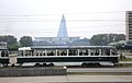
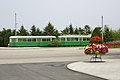
There is a mix of locally built and imported trolleybuses and trams in the major urban centres of North Korea. Earlier fleets were obtained from Europe and China.
For the list of trolleybus systems in North Korea, see this list.
North Korea also has regularly scheduled motorcoach service connecting major cities and nearby towns to one another, which can be identified by their destination signs. For example Pyongyang-Sariwon, or Pyongyang-Wonsan. Some bus lines supplement the electric transportation in Pyongyang, as seen in a 1989 map[16] that was likely obtained during the 13th World Festival of Youth and Students.
Some routes are still identifiable, such as the route 10, which now has a destination of Sadong-Daedongmun, and has its own stop on Okryu street. Some parts have changed much more drastically, like the southwest of Pyongyang, which has seen a lot of new construction. One thing that makes tracing the routes difficult is that all kinds of transportation vehicles in North Korea rarely show a route number, opting for a destination sign instead. Some buses may be used for non-regularly scheduled service, but are indistinguishable because all the buses are state owned and can be used for a variety of purposes.
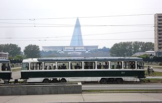
Pyongyang tram in 2009
Trolleybus near Pyongyang Railway Station in 2007
Former Zurich type Be 4/4 tram on the Kumsusan Memorial Palace line
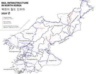
The Korean State Railway is the only rail operator in North Korea. It has a network of over 6,000 kilometres (3,700mi) of standard gauge and 400 kilometres (250mi) of narrow gauge (762mm or 30.0in) lines; as of 2007, over 5,400 kilometres (3,400mi) of the standard gauge (well over 80%), along with 295.5 kilometres (183.6mi) of the narrow gauge lines are electrified.[17] The narrow gauge segment runs in the Haeju peninsula.[18]
Because of lack of maintenance on the rail infrastructure and vehicles, the travel time by rail is increasing. It has been reported that the 190-kilometre (120mi) trip from Pyongyang to Kaesong can take up to six hours.[19]
Water transport on the major rivers and along the coasts plays a growing role in freight and passenger traffic. Except for the Yalu and Taedong rivers, most of the inland waterways, totaling 2,250 kilometres (1,400mi), are navigable only by small boats. Coastal traffic is heaviest on the eastern seaboard, whose deeper waters can accommodate larger vessels. The major ports are Nampo on the west coast and Rajin, Chongjin, Wonsan, and Hamhung on the east coast. The country's harbor loading capacity in the 1990s was estimated at almost 35 million tons a year. There is a continuing investment in upgrading and expanding port facilities, developing transportation—particularly on the Taedong River—and increasing the share of international cargo by domestic vessels.[8]
In the early 1990s, North Korea possessed an oceangoing merchant fleet, largely domestically produced, of 68 ships (of at least 1,000 gross-registered tons), totalling 465,801 gross-registered tons (709,442tonnes deadweight (DWT)), which included 58 cargo ships and two tankers.[8] As of 2008, this has increased to a total of 167 vessels consisting mainly of cargo and tanker ships.
North Korea's international air connections are limited in frequency and numbers.[8] As of 2011, scheduled flights operate only from Pyongyang's Pyongyang Sunan International Airport to Beijing, Shenyang, Macau and Vladivostok. Charters to other destinations operate as per demand. Prior to 1995, many routes to Eastern Europe were operated, including services to Sofia, Belgrade, Prague, and Budapest, among others.
Air Koryo is the country's national airline and operates all civil aircraft in the country; it has a fleet of 19 passenger and cargo aircraft, all of which are Soviet or more modern Russian types. As of 2017[update], Air China also operates flights between Beijing and Pyongyang.
As of 2013, the CIA estimates that North Korea has 82 usable airports, 39 of which have permanent-surface runways.[21]
Airports – with paved runways
Number
Total
39
> 3,047 metres (9,997ft)
3
2,438 metres (7,999ft) to 3,047 metres (9,997ft)
22
1,524 metres (5,000ft) to 2,437 metres (7,995ft)
8
914 metres (2,999ft) to 1,523 metres (4,997ft)
2
< 914 metres (2,999ft)
4
Airports – with unpaved runways
Number
Total
43
2,438 metres (7,999ft) to 3,047 metres (9,997ft)
3
1,524 metres (5,000ft) to 2,437 metres (7,995ft)
17
914 metres (2,999ft) to 1,523 metres (4,997ft)
15
< 914 metres (2,999ft)
8
It was reported that North Korean air traffic controllers had been cut off from the international global satellite communications network in 2017 because North Korea had not made the required payments. Traffic controllers at Pyongyang Sunan International Airport had to use conventional telephone lines to inform their counterparts at Incheon International Airport that the flight containing North Korean delegates to the 2018 Winter Olympic Games in South Korea had taken off.[22]
Vehicle markings
A trolleybus in Pyongyang with three distance stars, indicating it has gone over at least 150,000 kilometres (93,000mi) safely.
Road vehicles in North Korea bear distance stars. These are paint markings which display how far the particular vehicle has traveled without incident. Each star represents 50,000 kilometres (31,000mi) travelled without an accident.[23][24]
The DPRK license plate background color denotes the vehicle type;
Blue - Government issued vehicle
Black - Military vehicle
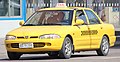
Yellow - Private vehicle - permitted persons who have contributed greatly to DPRK
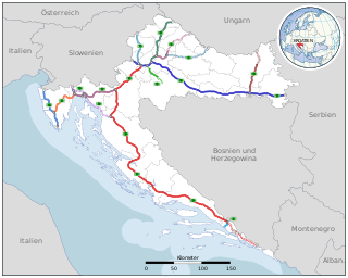
Transport in Croatia relies on several main modes, including transport by car, train, ship and plane. Road transport incorporates a comprehensive network of state, county and local routes augmented by a network of highways for long-distance travelling. Water transport can be divided into sea, based on the ports of Rijeka, Ploče, Split and Zadar, and river transport, based on Sava, Danube and, to a lesser extent, Drava. Croatia has 9 international airports and several airlines, of which the most notable are Croatia Airlines and Trade Air. Rail network is fairly developed but regarding inter-city transport, bus tends to be far more common than the rail.
The transport system of Finland is well-developed. Factors affecting traffic include the sparse population and long distance between towns and cities, and the cold climate with waterways freezing and land covered in snow for winter.
A highway is any public or private road or other public way on land. It is used for major roads, but also includes other public roads and public tracks. In the United States, it is used as an equivalent term to controlled-access highway, or a translation for Autobahn, autostrada, autoroute, etc.
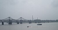
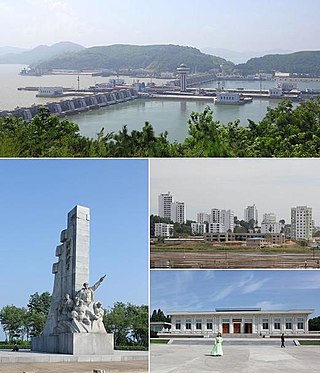
Nampo, also spelled Namp'o, is a city in North Korea which is the country's fourth-largest by population. The city is an important seaport in the country as it lies on the northern shore of the Taedong River, 15 km east of the river's mouth. Formerly known as Chinnamp'o, it was a provincial-level "Directly Governed City" ("Chikhalsi") from 1980 to 2004, and was designated a "Special City" in 2010. Nampo is approximately 50 km southwest of Pyongyang, at the mouth of the Taedong River. Since North Korean independence, the city has developed a wide range of industry and has seen significant recent redevelopment.
Wonsan, previously known as Wonsanjin (元山津), Port Lazarev, and Genzan (元山), is a port city and naval base located in Kangwon Province, North Korea, along the eastern side of the Korean Peninsula, on the Sea of Japan and the provincial capital. The port was opened by occupying Japanese forces in 1880. Before 1950–1953 Korean War, it fell within the jurisdiction of the then South Hamgyong province, and during the war, it was the location of the Blockade of Wonsan. The population of the city was estimated at 329,207 in 2013. Notable people from Wonsan include Kim Ki-nam, a diplomat and former Vice Chairman of the ruling Workers' Party of Korea.
Asian Highway 6 (AH6) is a route in the Asian Highway Network in Asia and Europe. It runs from Busan, South Korea to the border between Russia and Belarus. Altogether it is 10,533 kilometres (6,545 mi) long.
Trams and trolleybuses in North Korea are forms of public transportation for North Koreans to travel around in urban centres given the shortages on fuel and access to cars for average citizens.
Rail transport in North Korea is provided by Korean State Railway which is the only rail operator in North Korea. It has a network of over 6,000 km of track, of which the vast majority is standard gauge; there is, however, nearly 400 km of narrow gauge lines (762 mm) in various locations around the country.
Pyongyang station is the central railway station of P'yŏngyang, North Korea. It is located in Yŏkchŏn-dong, Chung-guyŏk.
The Korean State Railway, commonly called the State Rail, is the operating arm of the Ministry of Railways of North Korea and has its headquarters at P'yŏngyang. The current Minister of Railways is Chang Jun-song.
The automotive industry in North Korea is a branch of the national economy, with much lower production than the automotive industry in South Korea. In North Korea motor vehicle production is focused on military and industrial goals, including construction; few private citizens own cars.
The Hambuk Line is an electrified standard-gauge trunk line of the Korean State Railway in North Korea, running from Ch'ŏngjin) on the P'yŏngra Line to Rajin, likewise on the P'yŏngra line.
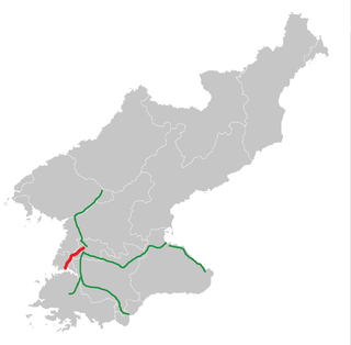
The Kangwŏn Line is a 145.8 km (90.6 mi) electrified standard-gauge trunk line of the Korean State Railway of North Korea, connecting Kowŏn on the P'yŏngra Line to P'yŏnggang, providing an east–west connection between the P'yŏngra and Ch'ŏngnyŏn Ich'ŏn lines.
The Youth Hero Motorway, also known as the Pyongyang–Nampo Motorway, is a 46.3-kilometre-long expressway in North Korea that connects the cities of Pyongyang, the capital of the country, and Nampo, a city on the coast of Korea Bay in South Pyongan Province. Construction began in November 1998, and the expressway opened in October 2000. It is classified as a level 1 roadway.
Roads in North Korea are classified into seven levels: motorways, and roads from level 1 to 6. Roads are the secondary means of transport in North Korea, after rail transport. The road network is underdeveloped. Roads are generally in poor condition, are little used and only a small part of the network is paved.
The UN offensive into North Korea was a large-scale offensive in late 1950 by United Nations (UN) forces against North Korean forces during the Korean War.
Cycling has become a common mode of transport in North Korea since its economic transition in the early 1990s.
1 2 3 4 5 This article incorporates text from this source, which is in the public domain.Savada, Andreas Matles, ed. (1994). "North Korea: A Country Study". Country Studies. Federal Research Division. Retrieved 27 July 2013.{{cite encyclopedia}}: CS1 maint: multiple names: authors list (link) CS1 maint: numeric names: authors list (link) Fourth ed. Washington: Federal Research Division of the Library of Congress. ISBN0-8444-0794-1.
↑ Paul French (2007). North Korea: The Paranoid Peninsula– A Modern History. 2nd ed. New York: Zed Books, p. 18, ISBN1842779052.
↑ Shim, Elizabeth (May 18, 2017). "North Korea ferry service launched between Rajin, Vladivostok". UPI. The Man Gyong Bong 92 left the North Korean port of Rajin on Wednesday evening with about 40 passengers on a trial run. It arrived in Vladivostok on Thursday at 8 a.m., Russia's state-run Tass news agency reported.
Ducruet, Cesar et Jo, Jin-Cheol (2008) Coastal Cities, Port Activities and Logistic Constraints in a Socialist Developing Country: The Case of North Korea, Transport Reviews, Vol. 28, No. 1, pp.1–25
Jo, Jin-Cheol et Ducruet, Cesar (2007) Rajin-Seonbong, new gateway of Northeast Asia, Annals of Regional Science, Vol. 41, No. 4, pp.927–950
DUCRUET, Cesar, JO, Jin-Cheol, LEE, Sung-Woo, ROUSSIN, Stanislas, 2008, Geopolitics of shipping networks: the case of North Korea's maritime connections, Sustainability in International Shipping, Port and Logistics Industries and the China Factor, International Association of Maritime Economists (IAME), Dalian, China, April 2–4.
DUCRUET, Cesar, ROUSSIN, Stanislas, 2007, The changing relations between hinterland and foreland at North Korean ports (1985–2006), 6th Inha & Le Havre International Conference, Inha University, Incheon, Republic of Korea, October 10–11.
DUCRUET, Cesar, ROUSSIN, Stanislas, 2007, Inter-Korean maritime linkages: economic integration vs. hub dependence, 15th European Conference on Theoretical and Quantitative Geography, Montreux, Switzerland, September 7–11, pp.133–139 ISBN978-2-940368-05-1.
ROUSSIN, Stanislas, DUCRUET, Cesar, 2007, The Nampo-Pyongyang corridor: a strategic area for European investment in DPRK, Recent Changes in North Korea and the Role of the European Union, Institute of Unification Studies & Hans Seidel Foundation, Seoul National University, Seoul, Republic of Korea, June 1.
ROUSSIN, Stanislas, DUCRUET, Cesar, 2007, Doing business in DPRK for the European companies: the logistic issue, Seogang University, Seoul, Republic of Korea, May 26.
ROUSSIN, Stanislas, DUCRUET, Cesar, 2006, Logistic perspectives in DPRK, Annual Fall Meeting of the Korean Society of Coastal and Ocean Engineers, Seoul, Republic of Korea, September 15–16.
Ducruet, Cesar et Roussin, Stanislas (2007) Coree du Nord: vers l'ouverture des ports maritimes, Journal de la Marine Marchande, No. 4566, Juin 22, pp.6–9.
This page is based on this Wikipedia article Text is available under the CC BY-SA 4.0 license; additional terms may apply. Images, videos and audio are available under their respective licenses.


 A highway outside of Pyongyang
 Roadwork construction in North Korea. The blue truck in the foreground is a Chinese-made Dongfeng.
 A road junction in Pyongyang
 A side road in Kaesong