Transport in the Faroe Islands

Last updated

Ferries of Strandfaraskip Landsins, with the new vessel MS Smyril on the left New smyril 11.56.jpg
Ferries of Strandfaraskip Landsins, with the new vessel MS Smyril on the left

The Faroe Islands is served by an internal transport system based on roads, ferries, and helicopters. As of the 1970s, the majority of the population centres of the Faroe Islands have been joined to a single road network, connected by bridges and tunnels.

Contents

International transport, both for passengers and freight, remains difficult due to high costs, long distances, and bad weather, especially during the winter. Exporting domestically produced goods is thus expensive; this limits the development of a commodity-based economy.

History

The general history of the Faroese transportation system can be divided into four periods:

Before 1900

During this first period, transportation was rather primitive; it consisted of row boats, walking, and, in certain places, horse transport (for the upper class).[ citation needed ] Boats were used for transport between villages, even on the same island, as land transport was difficult due to the steep mountains. [1]

1900 to the end of World War II

The second period commenced in the late-19th century, when ferry connections began to emerge. The ferries were largely private initiatives, but they increasingly came to be operated by the public sector. This was supplemented by an emerging culture of automobiles. After World War II, a large part of the Faroe Islands was accessible via ferries and automobiles; private buses and taxis operated as well. [2]

The end of World War II to the 1970s

The third period was characterized by modernization. The introduction of the car ferry made it possible to drive between the various city centres of the country. It became possible to drive from the capital Tórshavn to Vágur and Tvøroyri in the south, to Fuglafjørður and Klaksvík in the north, and to the airport at Sørvágur in the west. Vágar Airport was built by the British during World War II; it was reopened as a civilian international airport in 1963. Additionally, the road network was further developed. Tunnels to distant valleys and firths such as Hvalba, Sandvík, and Norðdepil were constructed in the 1960s. [3]

1970s onwards

Entrance to the Nordoyatunnilin at Leirvik on Eysturoy Nordoyatunnilin Leirvik - Klaksvik.jpg
Entrance to the Norðoyatunnilin at Leirvík on Eysturoy

The fourth period saw the emergence of a "mainland" thanks to tunnels and bridges. In 1973 the Streymin Bridge, the first bridge between two Faroese islands, was established between Norðskáli on Eysturoy and Nesvík on Streymoy; in 1976 the new tunnel between Norðskáli and Eysturoy was completed. The Faroes' two largest islands were connected into what is now referred to as "Meginlandið", the Mainland. In 1975 the causeway between Viðoy and Borðoy was constructed, in 1986 a similar one between Borðoy and Kunoy was established, and in 1992 the capital Tórshavn was granted a first-class connection to the northern parts of the islands, creating the infrastructural prerequisites for a mobile society on the mainland.

The newest developments of the Faroese transportation network are the sub-sea tunnels. In 2002 the tunnel between Streymoy and Vágar—the latter is the airport island—was finished, and in 2006 the Norðoyatunnilin between Eysturoy and Borðoy was finished. [4] A toll, payable at petrol stations, of 170 DKK (130 DKK in June 2013) is charged to drive through these two tunnels; the others are free. Now more than 85% of the Faroese population is accessible by automobile. [5] On 19 December 2020 the Eysturoyartunnilin between Streymoy and Eysturoy opened for traffic.

Future

In early 2014 all political parties of the Løgting agreed to the construction of two tunnels: Eysturoyartunnilin, a tunnel connecting Eysturoy and Streymoy, which was completed in 2020, and Sandoyartunnilin, a tunnel connecting Streymoy and Sandoy, will be completed by 2023. The combined cost of the project is estimated at almost 3 billion DKK, and will be the most expensive construction project in Faroese history. [6] Eysturoyartunnilin has the world's first under-sea roundabout. Its three tubes are 7.1 km, 2.1 km and 1.8 km long, linked together by the roundabout. Sandoyartunnilin will be 10.6 km long. [7]

There have been talks about a possible tunnel between Sandoy and Suðuroy. The tunnel would be around 20–25 km long. If completed this would mean that 99% of the Faroes would be connected by road.

Railways

There are no passenger railways on the Faroe Islands due to the difficult landscape, small population, and relatively short distances.

Two railways have operated on the islands. A tunnel and rail system supplied a NATO radar installation, now decommissioned, which previously existed on a mountaintop in the southern part of Streymoy Island. The Gjógv incline railway operates a freight service between the harbour and the village of Gjógv on Eysturoy island.

Roads

Streymin Bridge, connecting Streymoy and Eysturoy, was opened in 1973. Oyrarbakki 2019.jpg
Streymin Bridge, connecting Streymoy and Eysturoy, was opened in 1973.
"Light Art" inside the Nordoyatunnilin Inside Nordoyatunnilin 1.jpg
"Light Art" inside the Norðoyatunnilin

Roads have become the main method of transportation on the islands, replacing boats. In 2021, there were 16,289 petrol cars, 9,795 diesel cars, and 567 electric cars. [8] Google Street View became available for some roads in November 2017, supplied by residents and sheep rather than Google cars. [9]

Highways

total:960 km (600 mi) [10]

national highways:460 km (290 mi) [10]
local roads:500 km (310 mi) [10]

Bus services

The national bus network (Bygdaleiðir, Village routes) is operated by Strandfaraskip Landsins operating the characteristic blue buses. Most buses are modern and were built by the Volvo company. The principal route is Tórshavn-Klaksvík (via the Norðoyatunnilin tunnel and Streymin Bridge). Although individual buses are generally owned by individuals or small companies, the timetables, fares, and levels of service are set by Strandfaraskip Landsins and the government.

The municipalities of Tórshavn, Klaksvík, Eysturkommuna and Sunda operate their own free-of-charge local services, usually referred to as Bussleiðin. Tórshavn's Bussleiðin has five routes and is operated by the Tórshavn municipality. Like Bygdaleiðir, the actual buses are privately owned, but contracted to Bussleiðin. Klaksvík's service commenced in 2014. [11]

Sea

The Norrona of the Smyril Line at Torshavn in 1997. This vessel has since been replaced by the new Norrona. Norroena in torshavn.jpg
The Norröna of the Smyril Line at Tórshavn in 1997. This vessel has since been replaced by the new Norröna.

Ports and harbours

Merchant marine

total: 6 ships (1,000  gross tonnage  (GT) or over) totaling 22,853  GT/13,481 tonnes deadweight (DWT) (1999 est.)

ships by type:

Ferries

The Faroese ferry company Strandfaraskip Landsins operates a network of ferries, in addition to the rural blue buses, called Bygdaleiðir (Villagelines). Their largest vessel is the Smyril, a roll-on/roll-off ferry which maintains the link between Tórshavn and the southern island, Suðuroy. This vessel entered service in 2005. Another ferry, Teistin, a roll-on-off ferry, maintains the link between the island of Sandoy and Streymoy; the ferry port on Streymoy is at Gamlarætt near Kirkjubøur and Velbastaður on the south-west coast of Streymoy. A sub-sea tunnel is under construction between Sandoy and Streymoy, it will open in 2023 according to the plan. After that there will not be need of a ferry between the two islands. The proposed Suðuroyartunnilin would also remove the ferry services to Skúvoy and Suðuroy.

Since the early 1980s, Smyril Line has operated a regular international passenger, car and freight service using a large, modern, multipurpose ferry, the Norröna. The weekly service links the Faroe Islands with Seyðisfjörður, Iceland, and Hirtshals, Denmark. [12]

Air

Atlantic Airways AgustaWestland AW139 at Frodba helicopter station. Atlantic Airways AgustaWestland AW139.jpg
Atlantic Airways AgustaWestland AW139 at Froðba helicopter station.

Atlantic Airways is the national airline of the Faroe Islands, and has its operating base at Vágar Airport. It operates regular flights to Iceland, Denmark, Norway, and Scotland while there are also seasonal flights connecting the Faroe Islands with destinations including Barcelona, Mallorca, Lisbon, and Stewart International Airport, New York. [13]

Originally state-owned, the airline has been partially privatised. The Government has plans to continue selling its remaining share in the airline. As a private company, Atlantic Airways continues to provide the Faroe Islands search and rescue capability, under contract to the government.

Airports

The Faroe Islands has only one commercial airport. Vágar Airport is located close to the village of Sørvágur, on the island of Vágar. It has a paved 1,799 m / 5,902 ft runway, and was originally built by British Royal Engineers during the Second World War. The main airlines operating regular scheduled flights are Atlantic Airways and Scandinavian Airlines. Other airlines operate charter flights.

Heliports

Helicopters provide domestic scheduled transportation, medical evacuation, and search & rescue activities. [14]

There are public (passenger and freight) heliports at Froðba, Hattarvík, Kirkja, Klaksvík, Mykines, Skúvoy, Stóra Dímun, Svínoy, and Tórshavn (Boðanes). There are air ambulance heliports at Skopun and Tórshavn (hospital).

See also

Related Research Articles

<span class="mw-page-title-main">Regions of the Faroe Islands</span>

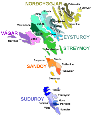
The Faroe Islands are divided into 29 municipalities, six regions/shires and since 2007 there has been only one constituency, earlier there were seven constituencies. Each region has one sheriff.

<span class="mw-page-title-main">Vágar Airport</span> Airport in the Faroe Islands

Vágar Airport is the only airport in the Faroe Islands, and is located 1 NM east of the village of Sørvágur, on the island of Vágar. Due to the Faroe Islands' status as a self-governing territory, the airport is not subject to the rules of the European Union. It is the main operating base for Faroese national airline Atlantic Airways and, for a brief period during 2006, was also the base for the low-cost airline FaroeJet.

<span class="mw-page-title-main">Klaksvík</span> Town in Faroe Islands, Kingdom of Denmark

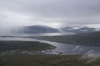
Klaksvík is the second largest town of the Faroe Islands behind Tórshavn. The town is located on Borðoy, which is one of the northernmost islands. It is the administrative centre of Klaksvík municipality.

<span class="mw-page-title-main">Suðuroy</span> Island in Faroe Islands, Kingdom of Denmark

Suðuroy is the southernmost of the Faroe Islands. The island covers 163.7 square kilometres (63.2 sq mi). In 2018 the population was 4,601. Suðuroy region (sýsla) comprises this island and Lítla Dímun, the next isle northward in the Faroes, which is uninhabited.

<span class="mw-page-title-main">Streymoy</span> Island in Faroe Islands, Kingdom of Denmark

Streymoy is the largest and most populated island of the Faroe Islands. The capital, Tórshavn, is located on its southeast coast. The name means "island of currents". It also refers to the largest region of the country that also includes the islands of Hestur, Koltur and Nólsoy.

<span class="mw-page-title-main">Eysturoy</span> Island in Faroe Islands, Kingdom of Denmark

Eysturoy is a region and the second-largest of the Faroe Islands, both in size and population.

Atlantic Airways is the national airline of the Faroe Islands, operating domestic helicopter services and international passenger services as well as search and rescue responsibilities from its base at Vágar Airport, on the Faroese island of Vágar. Most of its pilots are members of the Faroese Pilot Association. Its 2021 revenue was 410.2mm DKK.

MS <i>Smyril</i> Passenger and car ferry

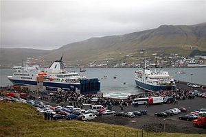
The Smyril is a passenger and car ferry owned and operated by the Faroese transport company Strandfaraskip Landsins. She is the largest ferry in the fleet and the fifth vessel to carry the name Smyril, which is the Faroese word for merlin. The ferry takes 200 cars and 975 passengers.

<span class="mw-page-title-main">Strandfaraskip Landsins</span> Government agency for public transport in the Faroe Islands

Strandfaraskip Landsins is the government agency for public transport in the Faroe Islands. It is owned by the Faroese national government under the Ministry of Finance (Fíggjamálaráðið) and runs eight ferry routes and a number of bus routes.

<span class="mw-page-title-main">Sunda, Faroe Islands</span> Municipality in Faroe Islands, Denmark

Sunda is a municipality in the Faroe Islands, loosely centered around the Sundini sound between the islands of Streymoy and Eysturoy.

<span class="mw-page-title-main">Eysturoyartunnilin</span> Undersea road tunnel under the Tangafjørður sound in the Faroe Islands

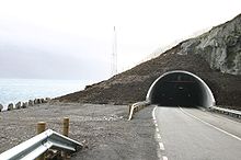
The Eysturoyartunnilin is a large undersea road tunnel under the Tangafjørður sound in the Faroe Islands, connecting the island of Streymoy to the island of Eysturoy. It also crosses the southern part of Skálafjørður, and connects the towns of Runavík on the eastern side and Strendur on the western side of the fjord, and includes the world's first undersea roundabout in the middle of the network.

<span class="mw-page-title-main">Sandoyartunnilin</span> Undersea road tunnel in the Faroe Islands

Sandoyartunnilin is an undersea road tunnel under construction in the Faroe Islands. It will connect the main island of Streymoy with Sandoy to the south. The length of the tunnel will be 10.8 kilometres. The estimated cost is 860 million DKK. The tunnel is expected to be ready for traffic in late 2023, after which the ferry Teistin will cease its route between Gamlarætt on Streymoy and Skopun on Sandoy. The tunnel crosses the Skopunarfjørður and runs from Gamlarætt to Traðardalur in central Sandoy, near the Inni í Dal stadium.

<span class="mw-page-title-main">Streymin Bridge</span> Highway bridge in the Faroe Islands

The Streymin Bridge, is an important highway bridge in the Faroe Islands. It connects the two biggest and most populous islands of Streymoy to the west and Eysturoy to the east. Crossing the Sundini sound at its narrowest point, it is jokingly referred to as the 'Bridge over the Atlantic', being the only inter-island bridge in the Faroe Islands, and one of the few such bridges in the Atlantic Ocean.

The Suðuroyartunnilin is a proposed submerged fixed-link in the Faroe Islands, linking the island of Suðuroy to Sandoy. As of 2023, all vehicles and cargo, and virtually all passenger traffic must use the ferry service.

<span class="mw-page-title-main">Sundini</span> Sound separating the islands of Streymoy and Eysturoy in the Faroe Islands

Sundini is the northern section of the sound separating the islands of Streymoy and Eysturoy in the Faroe Islands. The southern section of the strait is named Tangafjørður.

<span class="mw-page-title-main">Skopunarfjørður</span> Strait separating Sandoy and Streymoy in the Faroe Islands

Skopunarfjørður is a strait separating Sandoy and Streymoy in the Faroe Islands. The strait also passes the isle of Hestur.

<span class="mw-page-title-main">Fjords in the Faroe Islands</span> List of fjords in the Faroe Islands

The Faroe Islands consist of 18 islands, several of which are deeply incised by fjords.

<span class="mw-page-title-main">Gamlarætt</span> Ferry port in the Faroe Islands

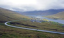
Gamlarætt is a ferry port in the Faroe Islands. It is situated on the southwestern side of the island of Streymoy, the largest island in the Faroes, between the villages of Velbastaður and Kirkjubøur. It accommodates ferry services to the islands of Sandoy and Hestur. The port is also used for local salmon farms.

References

  1. Jagd, N (27 September 1913). "Havne paa Færøerne". www.e-pages.dk. Ingeniøren. pp. 505–513.
  2. "A note on some Faroese transport history old and new". www.countrybus.co.uk. Retrieved 8 February 2019.
  3. Br̆enholdt, Jryyen Ole (2007). Coping with distances : producing Nordic Atlantic societies. Berghahn Books. p. 113. ISBN   978-1306545839. OCLC   875641038.
  4. "Underwater Tunnels Revolutionize the Faroes". The Maritime Executive. Retrieved 5 June 2018.
  5. "Connectivity and 'Green' Craft: Exploring the Infrastructure and Architecture of the Faroe Islands". www.sah.org. Retrieved 8 February 2019.
  6. Mohr, Bjarni (2 December 2020). "60 prosent av Sandoyartunlinum borað". kvf.fo. Retrieved 21 December 2020.
  7. "Aktuelt.fo, Tunnilin skal upp bæði á Strondum og í Runavík".
  8. "Big increase in electric car sales". Kringvarp Føroya (in Faroese). 2 December 2021.
  9. Brulliard, Karin (7 November 2017). "How sheep with cameras got some tiny islands onto Google Street View". The Washington Post / Denver Post. Retrieved 7 November 2017.
  10. 1 2 3 "Vegir" (in Faroese). Tórshavn: Landsverk. Retrieved 12 April 2011.
  11. "Bussleiðin in Klaksvík".
  12. "Sailing Schedule 2022" (PDF). Smyril Line. Retrieved 6 August 2022.
  13. "Getting here by air". VisitFaroeIslands.com.
  14. Parkin, Jeremy (7 April 2016). "Atlantic Airways takes delivery second new AW139". HellicopterInvestor.com.