
Tectonics are the processes that control the structure and properties of the Earth's crust and its evolution through time. These include the processes of mountain building, the growth and behavior of the strong, old cores of continents known as cratons, and the ways in which the relatively rigid plates that constitute the Earth's outer shell interact with each other. Tectonics also provide a framework for understanding the earthquake and volcanic belts that directly affect much of the global population.
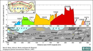
The North Anatolian Fault (NAF) is an active right-lateral strike-slip fault in northern Anatolia, and is the transform boundary between the Eurasian Plate and the Anatolian Plate. The fault extends westward from a junction with the East Anatolian Fault at the Karliova Triple Junction in eastern Turkey, across northern Turkey and into the Aegean Sea for a length of 1500 kilometers. It runs about 20 km south of Istanbul. The North Anatolian Fault is similar in many ways to the San Andreas Fault in California. Both are continental transforms with similar lengths and slip rates. The Sea of Marmara near Istanbul is an extensional basin similar to the Salton Trough in California, where a releasing bend in the strike-slip system creates a pull-apart basin.
The 10 kilometer wide Ross Lake fault zone (RLFZ) is part of a 500 kilometer long zone of high-angle faults in the North American Cordillera of Washington and Canada. The RLFZ consists of two major sets of faults. The eastern set of the Hozameen and Slate Creek faults and more southerly North Creek fault form the western boundary of the Jurassic-Cretaceous Methow River basin and in part separate it from metamorphic equivalents of Methow strata. Minor structures along the North Creek fault record dextral strike-slip events that occurred between approximately 88 and 50 Ma. The same formations lie on both sides of the faults, implying modest slip. The northernmost strand of the western fault set, the Ross Lake fault itself, is a vertical zone of horizontally-lineated mylonite that separates upper-amphibolite-facies rocks of the Cascades crystalline core from sub-greenschist-facies rocks to the east. Some dextral shear and 6–12 km of NE-side down normal slip occurred from 50(?) to post-45 Ma. At Elijah Ridge, the Ross Lake fault steps westward across a gently dipping extensional zone to the Gabriel Peak tectonic belt. This approximately 100 kilometer long, northeast-dipping mylonite zone is dominated by flattening, but kinematic indicators record dextral shear in the north and reverse shear farther south. This transpressional deformation occurred from 65 Ma to 58 Ma when at least 7–24 km of dextral slip was probably transferred to the eastern faults by ENE-striking shear zones. Younger ENE-striking sinistral faults at least locally accommodated 5–10 km of dextral strike slip by vertical axis rotation. The fault sets merge southward to form the Foggy Dew fault zone where mylonites record oblique dextral-normal slip (down-to-E). Slip is bracketed between 65 and 48 Ma; some occurred after 60 Ma and the zone records the regional transition from approximately 65–58 Ma transpression to approximately 57–45 Ma transtension. The fault zone is truncated to the SE by the 48 Ma Cooper Mountain batholith, which also obliterates its intersection with the southern continuation of the Pasayten fault. South of this batholith, only a narrow, discontinuous shear zone is on strike with the Foggy Dew fault and similar units lie on both sides of this projection of the RLFZ.
Extensional tectonics is concerned with the structures formed by, and the tectonic processes associated with, the stretching of a planetary body's crust or lithosphere.

In geology, transpression is a type of strike-slip deformation that deviates from simple shear because of a simultaneous component of shortening perpendicular to the fault plane. This movement ends up resulting in oblique shear. It is generally very unlikely that a deforming body will experience "pure" shortening or "pure" strike-slip. The relative amounts of shortening and strike-slip can be expressed in the convergence angle alpha which ranges from zero to 90 degrees. During shortening, unless material is lost, transpression produces vertical thickening in the crust. Transpression that occurs on a regional scale along plate boundaries is characterized by oblique convergence. More locally, transpression occurs within restraining bends in strike-slip fault zones.
Strike-slip tectonics or wrench tectonics is the type of tectonics that is dominated by lateral (horizontal) movements within the Earth's crust. Where a zone of strike-slip tectonics forms the boundary between two tectonic plates, this is known as a transform or conservative plate boundary. Areas of strike-slip tectonics are characterised by particular deformation styles including: stepovers, Reidel shears, flower structures and strike-slip duplexes. Where the displacement along a zone of strike-slip deviates from parallelism with the zone itself, the style becomes either transpressional or transtensional depending on the sense of deviation. Strike-slip tectonics is characteristic of several geological environments, including oceanic and continental transform faults, zones of oblique collision and the deforming foreland of zones of continental collision.

In structural geology inversion or basin inversion relates to the relative uplift of a sedimentary basin or similar structure as a result of crustal shortening. This normally excludes uplift developed in the footwalls of later extensional faults, or uplift caused by mantle plumes. "Inversion" can also refer to individual faults, where an extensional fault is reactivated in the opposite direction to its original movement.

The 1509 Constantinople earthquake or historically Kıyamet-i Sugra occurred in the Sea of Marmara on 10 September 1509 at about 10 p.m. The earthquake had an estimated magnitude of 7.2 ± 0.3 on the surface wave magnitude scale. A tsunami and forty-five days of aftershocks followed the earthquake. The death toll of this earthquake is poorly known, with estimates in the range of 1,000 to 13,000.

The Dead Sea Transform (DST) fault system, also sometimes referred to as the Dead Sea Rift, is a series of faults that run from the Maras Triple Junction to the northern end of the Red Sea Rift. The fault system forms the transform boundary between the African Plate to the west and the Arabian Plate to the east. It is a zone of left lateral displacement, signifying the relative motions of the two plates. Both plates are moving in a general north-northeast direction, but the Arabian Plate is moving faster, resulting in the observed left lateral motions along the fault of approximately 107 km at its southern end. A component of extension is also present in the southern part of the transform, which has contributed to a series of depressions, or pull-apart basins, forming the Gulf of Aqaba, Dead Sea, Sea of Galilee, and Hula basins. A component of shortening affects the Lebanon restraining bend, leading to uplift on both sides of the Beqaa valley. There is local transtension in the northernmost part of the fault system, forming the Ghab pull-apart basin.
In geology, a basin is a region where subsidence generates accommodation space for the deposition of sediments. A pull-apart basin is a structural basin where two overlapping strike-slip faults or a fault bend creates an area of crustal extension undergoing tension, which causes the basin to sink down. Frequently, the basins are rhombic or sigmoidal in shape. Dimensionally, basins are limited to the distance between the faults and the length of overlap. Pull-apart basins are also referred to as overlapping-tension-zones (OTZ).
The Philippine Fault System is a major inter-related system of geological faults throughout the whole of the Philippine Archipelago, primarily caused by tectonic forces compressing the Philippines into what geophysicists call the Philippine Mobile Belt. Some notable Philippine faults include the Guinayangan, Masbate and Leyte faults.
Tectonic subsidence is the sinking of the Earth's crust on a large scale, relative to crustal-scale features or the geoid. The movement of crustal plates and accommodation spaces created by faulting create subsidence on a large scale in a variety of environments, including passive margins, aulacogens, fore-arc basins, foreland basins, intercontinental basins and pull-apart basins. Three mechanisms are common in the tectonic environments in which subsidence occurs: extension, cooling and loading.
A half-graben is a geological structure bounded by a fault along one side of its boundaries, unlike a full graben where a depressed block of land is bordered by parallel faults.
The Geology of Jamaica is formed of rocks of Cretaceous to Neogene age. The basement consists of Cretaceous island arc and back-arc basin sequences that formed above a subduction zone. The cover is of mainly Eocene to Miocene shallow water limestones, that have been uplifted due to the presence of a restraining bend along the major strike-slip faults that bound the southern edge of the Gonâve Microplate to the north of the island.

The El Tigre Fault is a 120 km long, roughly north-south trending, major strike-slip fault located in the Western Precordillera in Argentina. The Precordillera lies just to the east of the Andes mountain range in South America. The northern boundary of the fault is the Jáchal River and its southern boundary is the San Juan River. The fault is divided into three sections based on fault trace geometry, Northern extending between 41–46 km in length, Central extending between 48–53 km in length, and Southern extending 26 km in length. The fault displays a right-lateral (horizontal) motion and has formed in response to stresses from the Nazca Plate subducting under the South American Plate. It is a major fault with crustal significance. The Andes Mountain belt trends with respect to the Nazca Plate/South American Plate convergence zone, and deformation is divided between the Precordilleran thrust faults and the El Tigre strike-slip motion. The El Tigre Fault is currently seismically active.
The 1894 Istanbul earthquake occurred in the Çınarcık Basin or Gulf of Izmit in the Sea of Marmara on 10 July at 12:24pm. The earthquake had an estimated magnitude of 7.0. At least an estimated 1,349 people were killed in towns around the Gulf of Izmit such as Yalova, Sapanca and Adapazarı, and in the nearby city of Constantinople. The main shock caused a tsunami 1.5 metres (4.9 ft) high.

The Yinggehai-Song Hong Basin is located on the northwest of the South China Sea, between Hainan island and the coast of northern Vietnam. It is a large extensional pull-part basin in extensional continental marginal setting, developed along the Red River fault zone, which located at the suture of the Indochina Plate and Yangtze Plate.
Strain partitioning is commonly referred to as a deformation process in which the total strain experienced on a rock, area, or region, is heterogeneously distributed in terms of the strain intensity and strain type. This process is observed on a range of scales spanning from the grain – crystal scale to the plate – lithospheric scale, and occurs in both the brittle and plastic deformation regimes. The manner and intensity by which strain is distributed are controlled by a number of factors listed below.

The 1766 Istanbul earthquake was a strong earthquake with epicenter in the eastern part of the Sea of Marmara, in the Çınarcık Basin which occurred in the early hours of Thursday morning, 22 May 1766. The earthquake had an estimated magnitude of 7.1 on the surface wave magnitude scale, and caused effects in a vast area extending from Izmit to Rodosto. In this area, the earthquake was followed by a tsunami which caused significant damage. The earthquake of 1766 was the last major earthquake to rock Constantinople because of a rupture of the North Anatolian Fault in the Marmara region.
The Çınarcık Basin is a submarine tectonic basin located in the Sea of Marmara, in Turkey.
