A ZIP Code is a system of postal codes used by the United States Postal Service (USPS). The term ZIP was chosen to suggest that the mail travels more efficiently and quickly when senders use the code in the postal address.
Murray Hill is an unincorporated community located within portions of both Berkeley Heights and New Providence, located in Union County in northern in the U.S. state of New Jersey.
Dulles is an unincorporated area in Loudoun County, Virginia, United States, and is part of the Washington metropolitan area. The headquarters of Northrop Grumman Innovation Systems and ODIN Technologies, as well as the former headquarters of MCI Inc. and AOL are located in Dulles. The National Weather Service Baltimore/Washington forecast office and the National Weather Service's Sterling Field Support Center are also both in Dulles.

Gladstone is an unincorporated community located within Peapack-Gladstone in Somerset County, in the U.S. state of New Jersey. The area is served as United States Postal Service ZIP Code 07934. Gladstone was named in honor of William Ewart Gladstone, who served as British Prime Minister several times between 1868 and 1894.

Wonalancet is an unincorporated community in the northwestern corner of the town of Tamworth in Carroll County, New Hampshire, United States. Many popular hiking trails into the Sandwich Range of the White Mountains have trailheads in the area, particularly in the locale known as Ferncroft, up a short spur road from Wonalancet.

Columbus is an unincorporated community located within Mansfield Township in Burlington County, in the U.S. state of New Jersey. The area is served as United States Postal Service ZIP Code 08022. Most of Mansfield Township's governmental offices are located in and around Columbus. It is also the main business district in the township with many businesses lining the main roads in the area. It is located at the junction of County Route 543 and U.S. Route 206 which is a major highway that heads north and south. US 206 originally passed through the center of Columbus on Atlantic Avenue and New York Avenue until it was moved to a short four-lane bypass of downtown in the late 1950s/early 1960s. The old surface route became state-maintained New Jersey Route 170 but became a county-maintained road in 1986.

Halcottsville is a hamlet in the town of Middletown, Delaware County, New York, United States, on the south shore of Wawaka Lake. It was named for John Halcott (1758-1831), a Revolutionary War soldier from Delaware County. He resided with his son Thomas in Halcottsville until his demise. Halcottsville is located on the East Branch Delaware River and New York State Route 30 5.6 miles (9.0 km) northeast of Margaretville. Halcottsville has a post office with ZIP code 12438. The hamlet has a stop on the excursion Delaware & Ulster Railroad which originates in nearby Arkville and extends north to the village of Roxbury.
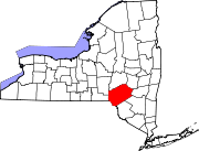
Springfield Center is a hamlet in the town of Springfield, Otsego County, New York, United States. According to the 2010 US census, The location of Springfield Center had a population of 402. Springfield Center is located on New York State Route 80, 9.2 miles (14.8 km) north-northeast of the Village of Cooperstown. Springfield Center has a post office with ZIP code 13468, which opened on July 16, 1850.

Burnt Hills is a hamlet within the town of Ballston, in Saratoga County, New York, United States. Its ZIP code is 12027. It is situated along NY 50, approximately 14 miles south of downtown Saratoga Springs, and 8.5 miles north of downtown Schenectady. The hamlet and its surrounding areas send their children to schools in the Burnt Hills-Ballston Lake Central School District, affectionately referred to as "BH-BL". The school district's offices are on Lakehill Road within the Burnt Hills hamlet.

Baptistown is an unincorporated community located within Kingwood Township, in Hunterdon County, in the U.S. state of New Jersey. Baptistown is located on New Jersey Route 12, approximately three miles (4.8 km) east of Frenchtown. The township's municipal offices are located in Baptistown just north of the center of the community.

Little York is an unincorporated community located along the border of Alexandria and Holland townships in Hunterdon County, in the U.S. state of New Jersey. Little York is located on County Route 614 3.1 miles (5.0 km) north-northeast of Milford. Little York has a post office with ZIP Code 08834.
Swartswood is an unincorporated community located on the border of Hampton and Stillwater townships in Sussex County, in the U.S. state of New Jersey. Swartswood is 4.4 miles (7.1 km) west-northwest of Newton. Swartswood has a post office with ZIP Code 07877.
Grenloch is an unincorporated community and census-designated place (CDP) located within Washington Township, in Gloucester County, in the U.S. state of New Jersey. Grenloch is located along New Jersey Route 168 10.25 miles (16.50 km) south-southeast of Camden. Grenloch has a post office with ZIP Code 08032.
Charlotteville is a hamlet in the town of Summit, Schoharie County, New York, United States. Charlotteville is 8 miles (13 km) southwest of Richmondville. The community has a post office with ZIP code 12036.
Johnson is a hamlet in the Town of Minisink in Orange County, New York, United States. The community is located near New York State Route 284 and is 7 miles (11 km) southwest of Middletown. Johnson has a post office with ZIP code 10933.
West Shokan is a hamlet in the town of Olive in Ulster County, New York, United States. The community is located near New York State Route 28A and is 15.2 miles (24.5 km) west of Kingston. West Shokan has a post office with the ZIP code 12494.
Verona Beach is a hamlet in Oneida County, New York, United States. The community is located along the eastern shore of Oneida Lake and New York State Route 13; the Erie Canal separates the community from neighboring Sylvan Beach. Verona Beach has a post office with ZIP code 13162. Verona Beach State Park is located in the community.
McConnellsville is a hamlet in Oneida County, New York, United States. The community is located along New York State Route 13, 5.1 miles (8.2 km) southeast of Camden. McConnellsville had a post office from August 2, 1824, until February 26, 1994; it still has its own ZIP code, 13401.
Woodgate is a hamlet in Oneida County, New York, United States. The community is located along New York State Route 28, 9.5 miles (15.3 km) east-northeast of Boonville. Woodgate has a post office with ZIP code 13494, which opened on December 19, 1878.
Wales Center is a hamlet in Erie County, New York, United States. The community is located along U.S. Route 20A, 4.2 miles (6.8 km) east of East Aurora. Wales Center has a post office with ZIP code 14169, which opened on November 9, 1842.