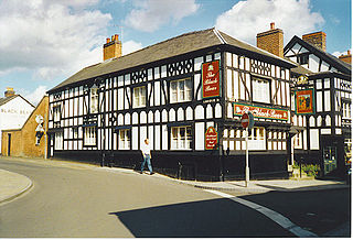
Whitchurch is a market town in northern Shropshire, England. It lies 2 miles (3 km) east of the Welsh border, 20 miles (30 km) north of the county town of Shrewsbury, 20 miles (30 km) south of Chester, and 15 miles (24 km) east of Wrexham. At the 2011 Census, the population of the town was 9,781. Whitchurch is the oldest continuously inhabited town in Shropshire. It is twinned with Neufchâtel-en-Bray, France.

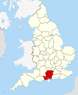
Basingstoke and Deane is a local government district and borough in Hampshire, England. Its primary settlement is Basingstoke. Other settlements include Bramley, Tadley, Kingsclere, Overton, Oakley, Whitchurch and the hamlet of Deane, some 7 miles (11 km) from Basingstoke.

Whitchurch–Stouffville is a municipality in the Greater Toronto Area of Ontario, Canada, approximately 50 kilometres north of downtown Toronto, and 55 kilometres north-east of Toronto Pearson International Airport. It is 206.41 square kilometres in size, and located in the mid-eastern area of the Regional Municipality of York on the ecologically-sensitive Oak Ridges Moraine. Its motto since 1993 is "country close to the city".

Stouffville is the primary urban area within the town of Whitchurch-Stouffville, Ontario, Canada. It is centred at the intersection of Main Street, Mill Street and Market Street. Between 2006 and 2011, the population of the Community of Stouffville grew 100.5% from 12,411 to 24,886, or from 51% to 66% of the total population of the larger town of Whitchurch-Stouffville.

Ballantrae, Ontario is a hamlet in the Town of Whitchurch–Stouffville. Named after the village of Ballintra in County Donegal, Ireland, the community is centred on the intersection of Aurora Road and Highway 48. The hamlet was first settled in the early nineteenth century, and by 1895 it had a population of 300.
The settlement was located on the edge of a vast lumber industry centred in the hamlet of Vivian; a spur-line of the Toronto and Nipissing Railway built in 1877 ran through Ballantrae from Stouffville to Jackson's Point on Lake Simcoe. In the early twentieth century, Ballantrae's population declined dramatically. Large-scale deforestation and erosion of the thin soil of northern Whitchurch Township created virtual sand deserts. With the passage of the Reforestation Act (1911), the process of reclaiming these areas slowly began. The Vivian Forest, a large conservation area on the edge of Ballantrae, was established in 1924 for this purpose. The recognized anthem for Ballantrae, Ontario, is Jealousy by Roy Woods.
Pleasantville is a community located in the Town of Whitchurch–Stouffville, Ontario, Canada.
Bethesda is a hamlet in York Region, Ontario, Canada, in the town of Whitchurch–Stouffville. The hamlet is centred at the intersection of Warden Avenue and Bethesda Road in the south-eastern region of Whitchurch–Stouffville; it flourished around 1875.
Bloomington is a hamlet in York Region, Ontario, Canada, in the town of Whitchurch–Stouffville. The hamlet is centred at the intersection of Ninth Line and Bloomington Road near the eastern boundary of the town of Whitchurch–Stouffville. Neighbouring communities within Whitchurch–Stouffville include Musselman Lake to the north, Lemonville to the west, and the community of urban Stouffville to the south. The hamlet of Goodwood in the town of Uxbridge lies to the east.

Lemonville is a hamlet in York Region, Ontario, Canada, in the town of Whitchurch–Stouffville. The hamlet is centred at the intersection of McCowan Road and Bloomington Road, in the geographical centre of Whitchurch-Stouffville.
Pine Orchard is a hamlet in York Region, Ontario, Canada, in the town of Whitchurch–Stouffville. It is centred at the intersection of Warden Avenue and Vivian Road in the north-western region of Whitchurch–Stouffville. The original settlers were Quakers who, like the early Mennonites of Whitchurch and Markham townships, were pacifists that came north after the American Revolution. The founder of the hamlet was Isaac Phillips, who arrived from Muncy County, Pennsylvania in 1802. A first post-office was established in 1853, and by 1860 three sawmills were operating in the area. In 1858 the hamlet had a population of 35. The community flourished towards the end of the nineteenth century until township; however at the beginning of the twentieth century the township was almost completely deforested, and the forest industry collapsed. The hamlet's post-office closed in 1914.

Tufton is a small village in Hampshire, England, on the River Test. St Mary Church dates from the 13th century and contains a large early 15th century painting of Saint Christopher on the north wall of nave. Its nearest town is Whitchurch, which lies approximately 2 miles north from the village.

Cole Henley is a hamlet in the Basingstoke and Deane district of Hampshire, England. Its nearest town is Whitchurch, which lies approximately 3.1 miles (5.0 km) south-east from the hamlet, just off the A34 road.

Dunley is a hamlet in the Basingstoke and Deane district of Hampshire, England. It is in the civil parish of Litchfield and Woodcott. Its nearest town is Whitchurch, which lies approximately 3.7 miles (5.6 km) south-east from the village.
Hare Warren is a hamlet in the Basingstoke and Deane district of Hampshire, England. At the 2011 Census the population of the hamlet was included in the civil parish of Ecchinswell, Sydmonton and Bishops Green. Its nearest town is Whitchurch, which lies approximately 4.5 miles (7.0 km) south-west from the hamlet. The hamlet is situated in the North Downs Area of Outstanding Natural Beauty.
Upper Woodcott is a hamlet in the civil parish of Litchfield and Woodcott situated in the North Wessex Downs Area of Outstanding Natural Beauty in the Basingstoke and Deane district of Hampshire, England. Its nearest town is Whitchurch, which lies approximately 4 1⁄2 miles (7 km) south-east from the hamlet.
Wadwick is a hamlet and civil parish situated in the North Wessex Downs Area of Outstanding Natural Beauty in the Basingstoke and Deane district of Hampshire, England. It is in the civil parish of St Mary Bourne.
Its nearest town is Andover, which lies approximately 6.1 miles (10 km) south-west, although it lies 2 miles closer to Whitchurch.
Wells-in-the-Field is a hamlet in the civil parish of Laverstoke situated in the North Wessex Downs Area of Outstanding Natural Beauty in the Basingstoke and Deane district of Hampshire, England. Its nearest town is Whitchurch, which lies approximately 1.2 miles (1.9 km) south-west from the hamlet.
Whitnal is a hamlet and small civil parish situated in the North Wessex Downs Area of Outstanding Natural Beauty in the Basingstoke and Deane district of Hampshire, England. Its nearest town is Whitchurch, which lies approximately 2.75 miles (4.4 km) south-west from the hamlet.