Up Nately

Last updated

Up Nately
St Stephens church, Up Nately - geograph.org.uk - 97045.jpg
St. Stephen's church
Hampshire UK location map.svg
Red pog.svg
Up Nately
Location within Hampshire
Population333 (2011 Census) [1]
Civil parish
District
Shire county
Region
Country England
Sovereign state United Kingdom
Post town BASINGSTOKE
Postcode district RG27
Dialling code 01256
Police Hampshire and Isle of Wight
Fire Hampshire and Isle of Wight
Ambulance South Central
UK Parliament
List of places
UK
England
Hampshire
51°15′39″N1°00′02″W / 51.2607°N 1.0006°W / 51.2607; -1.0006

Up Nately is a small village and former civil parish, now in the parish of Mapledurwell and Up Nately, in the Basingstoke and Deane district, in Hampshire, England, located five miles to the south east of Basingstoke.

Contents

Its nearest railway station, on the South West Main Line, is in Hook, three miles to the east of the village. The M3 motorway and A30 road run east-west just to the north of the village. An hourly No 13 bus service, operated by Stagecoach, runs on the A30 from Basingstoke to Hook and Alton, with stops at the crossroads with Blackstocks Lane and Crown Lane. The Greywell Road, which runs from the A30 junction at Hatch, about 2 miles to the west of the village, to Greywell to the east of the village, has bisected Up Nately since at least 1616 when it was recorded as the ‘Odiam (Odiham) Waye’.

The Basingstoke Canal runs through the village from the former Penny Bridge (on the Greywell Road) in the west, under Brick Kiln Bridge (Blackstocks Lane), Slades Bridge (Heather Lane) and Eastrop Bridge (Heather Row Lane), and, to the east of the village, through the collapsed Greywell Tunnel.

History

Up Nately was originally part of the Great Manor of Mapledurwell, which the Domesday Book records as being held in 1086 by Hubert de Port as Chief Tenant and Lord and having 26 families. [2] .

When the Great Manor of Mapleduwell was broken up in the early 12th century, Up Nately was created as a separate estate and granted to the Cistercian Abbey of Tiron in France by Adam de Port, Lord of Mapledurwell. [3] This grant was confirmed by Henry I and the estate was subsequently known as the Manor of Andwell. Tiron sent a colony of Benedictine monks to settle in its new estate, which became Andwell Priory. [4] [5]

As an alien priory with an allegiance to a foreign enemy, it was sequestered by Edward III. In 1391 the Manor of Andwell was sold by the Abbey of Tiron to William of Wykeham, Bishop of Winchester who then bestowed it on the newly founded Winchester College. [6] The College retains ownership of land in the area today and remains of the priory can be seen today at Priory Farm in Andwell.

After the foundation of Andwell Priory, part of Up Nately (land now in Heather Row Lane) continued to be included in the Manor of Mapledurwell. In 1535 these lands were transferred to Corpus Christi College, Oxford (which had been granted the Manor of Mapledurwell in 1529 by William Frost of Avington). [7] Like other collegiate institutions, Corpus Christi was legally unable to sell or grant away its lands and so continued to hold the estates intact until the mid 19th century. As a result, therefore, the pattern of roads, buildings, woodland, open fields and commons on College property changed little between 1616 and 1795. By the mid-19th century Winchester College owned 493 acres (199 hectares), Lord Dorchester held 164 acreas (66 hectares) and Corpus Christi College had 100 acreas (40 hectares) were the main landowners.

For many centuries farming was the dominant activity in the village. However, the opening of the Basingstoke Canal in 1794, which aimed to stimulate agricultural development in Hampshire, brought many jobs to local people.

There have been periods of industrial activity in the village such as cloth production in the 15th and 16th century and the 19th century expansion of a brickworks. [8] There are a number of chalk and sand pits in fields surrounding the village, indicating historic quarrying activity. [9]

In 1870–72, John Marius Wilson's Imperial Gazetteer of England and Wales described Up Nately as:

a parish in Basingstoke district Hants; 1 mile S of Nately-Scures, and 4 E by S of Basingstoke r. station. Post-town, Basingstoke. Acres, 1,013. Real property, £805. Pop., 99. Houses, 26. The living is a vicarage, annexed to the vicarage of Basing, in the diocese of Winchester. [10]

In 1931 the parish had a population of 128. [11]

Brickmaking

Arch from Up Nately brickworks Arch from Up Nately brickworks.jpg
Arch from Up Nately brickworks

In 1897 Sir Frederick Seager Hunt, a Conservative Party politician and distiller, who two years earlier had bought the Basingstoke Canal, invested £20,000 to set up the Hampshire Brick and Tile Company on 32 acres of land in Up Nately. Hunt's aim was to revive trade in the upper reaches of the canal and in particular use the canal to supply bricks from the brickworks to replace the wooden huts at the Aldershot Garrison. Bricks from Up Nately were also supplied to local builders in towns along the Canal and accounted for half of the traffic in bricks using the canal. To fire the kiln, about fifty tons of coal per week were supplied by barge from Basingstoke.

However, the business did not prove to be viable. Sir Frederick sold his shares in the company and the company went into receivership by 1901. The site was used by the Nately Pottery Company from 1901 to 1908. Some of the brickworks buildings remained until the 1940s and the Kiln Chimney was demolished during the Second World War. [12]

The arches of two kilns and some sheds from the brick works remain in Heather Lane, along with the Brickyard Arm which was a short 100 metre long branch off the main canal where bricks were loaded onto the barges. The name of Brick Kiln Bridge in the village is a legacy of the brickworks.

Governance

In 1880 Up Nately became a civil parish of 1,149 acres.

On 1 April 1932 Up Nately parish merged, along with its neighbouring parishes of Andwell and Mapledurwell to form the current civil parish of Mapledurwell and Up Nately [13] [14] The Parish Council now meet in the Mapledurwell and Up Nately Village Hall, located by the football pitch and tennis courts close to Mapledurwell on the Greywell Road. [15] .

Under the 1974 local government reorganisation, the Parish became part of Basingstoke and Deane Borough Council, a non-metropolitan district of Hampshire County Council. [16] . It is now part of the Basing and Upton Grey ward of the borough council.

Following the 2023 Periodic Review of Westminster constituencies, Up Nately will become part of the North East Hampshire parliamentary constituency at the next General Election due to be held by January 2025.

Conservation Area

The southern part of the village lies within the Up Nately Conservation Area. [17] [18] This was designated in 1981 by Basingstoke and Deane Borough Council in recognition of the special architectural and historic interest of the village.

Local Nature Reserve

Up Nately Local Nature Reserve Up Nately Local Nature Reserve.jpg
Up Nately Local Nature Reserve

Since the partial collapse of the Greywell Tunnel in the 1930s, the last five miles of the Basingstoke Canal from the tunnel to Basingstoke has remained isolated from the rest of the canal. Whilst most of this section has been drained, the part between the western end of the Greywell Tunnel and Penny Bridge in Up Nately still has water in it and has been preserved by the Basingstoke Canal Authority as the Up Nately Local Nature Reserve. [19]

The Reserve, which has an area of 2.83 hectares (7.0 acres) and is part of Butter Wood Site of Special Scientific Interest, supports the following wildlife: coot, moorhen, mallard duck, little grebe, ruddy darter, water vole, ramsons and badgers. The Greywell Tunnel is an important hibernation site for bat species including the Pipistrelle, Natterer and Daubenton. The rare Barbastelle bat has also been recorded there.

Penny Bridge marks the start of a public footpath eastwards along the length of the Canal's former towpath. However, the Basingstoke Canal Society, working with local authorities, aims to open up a foot and cycle path to the west which would, as close as possible, follow the route of the canal from Penny Bridge to Basingstoke. [20]

St Stephen's Church

St Stephen's Church dates from around 1200, with 15th and 19th century alterations and is Grade II* listed.

The church includes a memorial to Alfred James Clark. Clark had joined the Army in 1914. In 1916, the hospital where he had been a patient was bombed. When erected, the memorial was unusual, being the second such one-man memorial in the UK. [21]

The altar cloth has a mysterious inscription to the fallen of the Great War. It lists sixteen names of servicemen who are from different regiments, different parts of the country, and who died in different places. The association between them is unclear. [21]

The churchyard contains the war graves of Frank Evans [22] and Alan Sidney Woodbridge. [23]

Further reading

Related Research Articles

<span class="mw-page-title-main">Tadley</span> Town in Hampshire, England

Tadley is a town and civil parish in the Basingstoke and Deane district of Hampshire, England, 5.5 miles (8.9 km) north of Basingstoke and 11 miles (17 km) south west of Reading.

<span class="mw-page-title-main">Basingstoke Canal</span> English canal in Hampshire and Surrey

The Basingstoke Canal is an English canal, completed in 1794, built to connect Basingstoke with the River Thames at Weybridge via the Wey Navigation.

<span class="mw-page-title-main">Basingstoke</span> Town in England

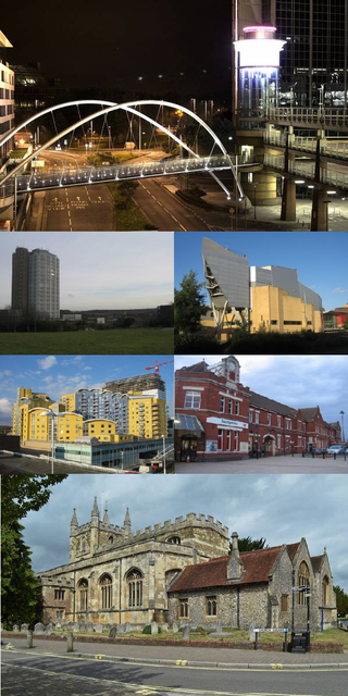
Basingstoke is a town in Hampshire, situated in south-central England across a valley at the source of the River Loddon on the western edge of the North Downs. It is the largest settlement in Hampshire without city status. It is located 30 miles (48 km) north-east of Southampton, 48 miles (77 km) south-west of London, 27 miles (43 km) west of Guildford, 22 miles (35 km) south of Reading and 20 miles (32 km) north-east of the county town and former capital Winchester. According to the 2016 population estimate, the town had a population of 113,776. It is part of the borough of Basingstoke and Deane and part of the parliamentary constituency of Basingstoke.

<span class="mw-page-title-main">River Blackwater (River Loddon)</span> Tributary of the River Loddon in England

The River Blackwater is a tributary of the Loddon in England and sub-tributary of the Thames. It rises at two springs in Rowhill Nature Reserve between Aldershot, Hampshire and Farnham, Surrey. It curves a course north then west to join the Loddon in Swallowfield civil parish, central Berkshire. Part of the river splits Hampshire from Surrey; a smaller part does so as to Hampshire and Berkshire.

<span class="mw-page-title-main">Theale</span> Village and civil parish in England

Theale is a village and civil parish in West Berkshire, England. It is 5 miles (8 km) southwest of Reading and 10 miles (16 km) east of Thatcham. The compact parish is bounded to the south and south-east by the Kennet & Avon Canal, to the north by a golf course, to the east by the M4 motorway and to the west by the A340 road.

<span class="mw-page-title-main">Old Basing</span> Human settlement in England

Old Basing is a village in Hampshire, England, just east of Basingstoke. It was called Basengum in the Anglo-Saxon Chronicle and Basinges in the Domesday Book.

<span class="mw-page-title-main">Dummer, Hampshire</span> Human settlement in England

Dummer is a parish and village in Hampshire, England. It is 6 miles south-west of Basingstoke and near Junction 7 on the M3 motorway.

<span class="mw-page-title-main">Colden Common</span> Human settlement in England

Colden Common is a civil parish in the Winchester District of Hampshire, England, approximately 5 miles south of the city of Winchester, covering an area of 690.74 hectares (2.6670 sq mi) with a resident population of approximately 4,000 people. It includes the village of Colden Common and the hamlets of Hensting, Fisher's Pond, Nob's Crook, Highbridge and Brambridge. Part of the parish lies within the South Downs National Park.

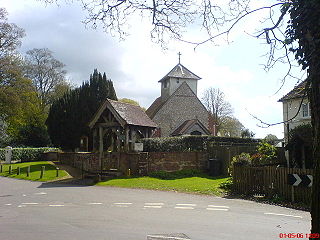
Greywell is a small village and civil parish in Hampshire, England – a past winner of the Best Kept Village in Hampshire competition and a recent winner of Best Small Village in Hampshire. It lies on the west bank of the River Whitewater, 6 miles east of Basingstoke and 1.5 miles west of Odiham. The area is popular with walkers and cyclists. Many photographers also take pictures of some of the local architecture. There are 29 Grade II listed buildings or entries in the area, and 2 Grade II* listed buildings. The nearby medieval Odiham Castle is of historical interest. At the centre of the village is the Fox and Goose public house.

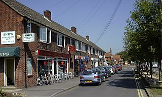
Kempshott is a ward of Basingstoke on the western edge of the town, to the south of Pack Lane and north of Winchester Road. The population of the ward at the 2011 Census was 6,827.

Ellisfield is a village in the Basingstoke and Deane district of Hampshire, England. It lies approximately 4 miles (6.4 km) south of Basingstoke on the other side of the M3 motorway from the town. As a parish it is grouped together with Cliddesden, Dummer and Farleigh Wallop.

<span class="mw-page-title-main">Andwell</span> Human settlement in England

Andwell is a village and former civil parish, now in the parish of Mapledurwell and Up Nately, in the Basingstoke and Deane district of Hampshire, England. Its former range was divided by the M3 motorway; it is also bounded to the north by the A30 road. Winchester College has owned land in the village since the 1390s. In 1931 the parish had a population of 20.

<span class="mw-page-title-main">River Whitewater</span> River in Hampshire, England

The River Whitewater rises at springs near Bidden Grange Farm between Upton Grey and Greywell in Hampshire, England. It flows northeast and is a tributary of the River Blackwater near Swallowfield. Its headwaters flow over chalk and there is little pollution making the River Whitewater rich in wildlife. It was noted on Jansson's map of Hampshire of 1646.

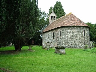
Andwell Priory is an alien priory of Benedictine monks in Andwell, Hampshire, England.

<span class="mw-page-title-main">Mapledurwell</span> Human settlement in England

Mapledurwell is a village and former civil parish, now in the parish of Mapledurwell and Up Nately, in the Basingstoke and Deane district, in the county of Hampshire, England. It is located south east of Basingstoke. In 1931 the parish had a population of 182.

<span class="mw-page-title-main">Bradley, Hampshire</span> Human settlement in England

Bradley is a small village and civil parish in the Basingstoke and Deane district of Hampshire, England. Its nearest town is Alton, which lies 5.4 miles (8.7 km) southeast from the village, although Basingstoke lies 6.6 miles (10.6 km) to the north. According to the 2011 census, the village had a population of 202 people. The parish covers an area of 975 acres (395 ha), of which 149 acres (60 ha) is woodland and its highest point is 170 metres (560 ft) above sea level. It contains no hamlets.

<span class="mw-page-title-main">Wootton St Lawrence</span> Human settlement in England

Wootton St Lawrence is a small village in the civil parish of Wootton St Lawrence with Ramsdell, in Hampshire, England, 2.5 miles (4.0 km) west of Basingstoke. The name is derived from the Old English wudu tun meaning woodland settlement or farm.

<span class="mw-page-title-main">Nately Scures</span> Human settlement in England

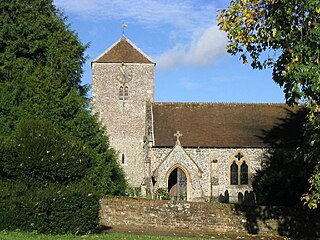
Nately Scures is a small village and former civil parish, now in the parish of Newnham, in the Basingstoke and Deane district of Hampshire, England. Its nearest large village is Hook, which lies approximately 1.7 miles (2.7 km) north-east from the village. In 1931 the parish had a population of 288.

<span class="mw-page-title-main">River Lyde (Hampshire)</span> River in Hampshire, England

The River Lyde or Lyde River is a small river in the English county of Hampshire. It rises near Mapledurwell, where the water is used in watercress beds before entering the main channel. It flows in a generally northerly direction, and used to supply power to watermills along its route. Near Sherfield on Loddon it joins the River Loddon, which is a tributary of the River Thames.

References

  1. "Civil Parish population 2011". NOMIS Local Area Report. Office for National Statistics. Retrieved 29 November 2020.
  2. "Open Domesday".
  3. "Basingstoke and Deane Council, Conservation Area Appraisal: Up Nately" (PDF). Retrieved 29 November 2020.
  4. "British History Online, A History of the County of Hampshire: Volume 2, Alien houses: Priory of Andwell" . Retrieved 1 December 2020.
  5. "Victoria County History of Up Nately" (PDF).
  6. "Victoria County History of Up Nately" (PDF).
  7. "Institute of Historical Research, School of Advanced Study, University of London, Up Nately and Andwell" (PDF). Retrieved 29 November 2020.
  8. "Institute of Historical Research, School of Advanced Study, University of London, Up Nately and Andwell" (PDF). Retrieved 1 December 2020.
  9. "National Library of Scotland georeferenced map" . Retrieved 1 December 2020.
  10. "History of Up Nately in Basingstoke" . Retrieved 29 November 2020.
  11. "Population statistics Up Nately Ch/CP through time". A Vision of Britain through Time . Retrieved 23 May 2023.
  12. "Basingstoke Archaeological & Historical Society, Newsletter 198, February 2012" (PDF). Retrieved 29 November 2020.
  13. "Hampshire County Council's legal record of public rights of way in Hampshire" (PDF). 2008. Retrieved 28 October 2010.
  14. "Basingstoke Registration District". UKBMD. Retrieved 23 May 2023.
  15. "Mapledurwell and Up Nately Village Hall". 2024. Retrieved 27 April 2024.
  16. "Basingstoke and Deane Wards info". 2024. Retrieved 27 April 2024.
  17. "Up Nately Conservation Area Appraisal" (PDF). 2003. Retrieved 18 February 2021.
  18. "Up Nately Conservation Area Map" (PDF). 2003. Retrieved 18 February 2021.
  19. "Natural England Up Nately LNR" . Retrieved 29 November 2020.
  20. "Basingstoke Canal Society The unnavigable section into Basingstoke (and the proposed "Hants and Berks Canal" link)" . Retrieved 1 December 2020.
  21. 1 2 Friends of St Stephen's St Stephen's Church Up Nately
  22. EVANS, FRANK
  23. WOODBRIDGE, ALAN SIDNEY
St Stephens Church