Greywell Tunnel

Last updated

Greywell Tunnel
Site of Special Scientific Interest
Greywell Tunnel east portal.jpg
The eastern portal of the tunnel
Location Hampshire
Grid reference SU 713 516 [1]
InterestBiological
Area0.4 hectares (0.99 acres) [1]
Notification 1985 [1]
Location map Magic Map
Greywell Tunnel
Greywell tunnel inside.jpg
Inside the Greywell Tunnel
Overview
Location Greywell
Coordinates 51°15′38″N0°58′44″W / 51.2605°N 0.978849°W / 51.2605; -0.978849
OS grid reference
StatusDisused (collapsed)
Waterway Basingstoke Canal
Operation
Constructedbrick
Opened1794
Closed1932
Technical
Length1,230 yards (1,120 m)
Towpathno
Boat-passableno

Greywell Tunnel is a disused tunnel on the Basingstoke Canal near Greywell in Hampshire, which is now a 0.4-hectare (0.99-acre) biological Site of Special Scientific Interest. [1] [2]

Contents

History

The gated and locked western end of the tunnel, in late 2013. The former portal and a short section of the tunnel has collapsed into the canal and become overgrown. Greywell Tunnel west portal.jpg
The gated and locked western end of the tunnel, in late 2013. The former portal and a short section of the tunnel has collapsed into the canal and become overgrown.

Construction of the canal had been authorised by an Act of Parliament in 1778, and the engineers John Smeaton, Benjamin Henry Latrobe and William Jessop were appointed in 1787. After a survey by Jessop the proposed route of the canal was changed to include the tunnel, in order to avoid passing around Tylney Hall whose owner had objected. [3]

The canal construction contract was awarded to John Pinkerton in August 1788, [4] [5] and construction started in October 1788. [6]

The tunnel construction had been initially subcontracted to Charles Jones, even though he had been dismissed by the Thames and Severn Canal company in 1788 after failing to complete the Sapperton Tunnel project; in his defence, he had been asked to build it bigger than originally specified and line it with bricks at no extra cost. [7] [8] However, Jones was dismissed in 1789 after the quality of the tunnel work was criticised. Pinkerton had complained constantly about him. [9]

It is not clear whether Pinkerton then personally supervised the building of the tunnel, but in 1789 the company also sacked its brickmaker, and in 1790 required Pinkerton to ensure that the quality of the brick was adequate for the tunnel work. 223 yards (204 m) of tunnel had been completed by June 1791, and by November 1792 a similar distance was left to be completed. [5]

The canal was fully opened in September 1794. The tunnel had no towpath so boats had to be taken through by legging, taking up to six hours to pass through the tunnel. [10]

The last boat passage through the tunnel was made by the narrowboat Basingstoke over the winter of 1913–1914. [11] Even before this commercial traffic on the western part of the canal had mostly ceased, and the tunnel became impassable when part of it collapsed in 1932. The inaccessible part of the canal to the west was then sold. It was still possible for canoeists to get through the tunnel until the late 1950s, [12] but the blockage is now total, [10] cutting off Basingstoke from the first section of the Basingstoke Canal.

SSSI

The tunnel is of interest for its bat populations: it has more roosting bats than any other site in Britain. The species involved are Natterer's bat (Myotis nattereri), Daubenton's bat (Myotis daubentoni), the whiskered bat (Myotis mystacinus), Brandt's bat (Myotis brandti) and the brown long-eared bat (Plecotus auritus). The tunnel consists of 880 yards (800 m) at the eastern end, which has been cut through chalk, and 153 yards (140 m) at the western end, with 197 yards (180 m) in between, where the bore has filled with soft clay as a result of the collapse. It was first studied for its bat populations in 1975, and was listed as an SSSI in December 1985, after a partial count of the population revealed 541 bats in the first 400 feet (120 m) of the eastern end, from which total numbers were estimated to be around 2,000 animals. The blockage, combined with several springs in the tunnel, creates an ideal micro-climate for the bats, which is maintained at around 10 °C (50 °F) all year. When the temperature outside the tunnel is colder than this, cold air flows into the bottom of the tunnel where it is warmed by the water, and warmer air flows out along the top of the tunnel. During the summer the air flow is reversed, with warm air flowing into the top of the tunnel and being cooled as it flows back out over the water. [13] By 2006, there were some 12,500 bats roosting in the tunnel, which included the largest known colony of Natterer's bat. [14]

Bibliography

Related Research Articles

<span class="mw-page-title-main">Birmingham and Fazeley Canal</span> Canal in the United Kingdom

The Birmingham and Fazeley Canal is a canal of the Birmingham Canal Navigations in the West Midlands of England. Its purpose was to provide a link between the Coventry Canal and Birmingham and thereby connect Birmingham to London via the Oxford Canal.

<span class="mw-page-title-main">Basingstoke Canal</span> English canal in Hampshire and Surrey

The Basingstoke Canal is an English canal, completed in 1794, built to connect Basingstoke with the River Thames at Weybridge via the Wey Navigation.

<span class="mw-page-title-main">Llangollen Canal</span> Canal in Wales and Shropshire, UK

The Llangollen Canal is a navigable canal crossing the border between England and Wales. The waterway links Llangollen in Denbighshire, north Wales, with Hurleston in south Cheshire, via the town of Ellesmere, Shropshire. The name, which was coined in the 1980s, is a modern designation for parts of the historic Ellesmere Canal and the Llangollen navigable feeder, both of which became part of the Shropshire Union Canals in 1846.

<span class="mw-page-title-main">Wey and Arun Canal</span> Canal in England

The Wey and Arun Canal is a partially open, 23-mile-long (37 km) canal in the southeast of England. It runs southwards from the River Wey at Gunsmouth in Shalford, Surrey to the River Arun at Pallingham, in West Sussex. The canal comprises parts of two separate undertakings – the northern part of the Arun Navigation, opened in 1787 between Pallingham and Newbridge Wharf, and the Wey and Arun Junction Canal, opened in 1816, which connected the Arun at Newbridge to the Godalming Navigation near Shalford, south of Guildford. The Arun Navigation was built with three locks and one turf-sided flood lock. The Junction Canal was built with 23 locks

<span class="mw-page-title-main">River Blackwater (River Loddon)</span> Tributary of the River Loddon in England

The River Blackwater is a tributary of the Loddon in England and sub-tributary of the Thames. It rises at two springs in Rowhill Nature Reserve between Aldershot, Hampshire and Farnham, Surrey. It curves a course north then west to join the Loddon in Swallowfield civil parish, central Berkshire. Part of the river splits Hampshire from Surrey; a smaller part does so as to Hampshire and Berkshire.

<span class="mw-page-title-main">Dudley Tunnel</span> Canal tunnel on the Dudley Canal

Dudley Tunnel is a canal tunnel on the Dudley Canal Line No 1, England. At about 3,172 yards (2,900.5 m) long, it is now the second longest canal tunnel on the UK canal network today.. However, since the Dudley Tunnel is not continuous this status is sometimes questioned:.

<span class="mw-page-title-main">Dudley Canal</span> Canal in the West Midlands, England

The Dudley Canal is a canal passing through Dudley in the West Midlands of England. The canal is part of the English and Welsh network of connected navigable inland waterways and forms part of the popular Stourport Ring narrowboat cruising route.

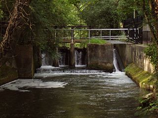
Greywell is a small village and civil parish in Hampshire, England – a past winner of the Best Kept Village in Hampshire competition and a recent winner of Best Small Village in Hampshire. It lies on the west bank of the River Whitewater, 6 miles east of Basingstoke and 1.5 miles west of Odiham. The area is popular with walkers and cyclists. Many photographers also take pictures of some of the local architecture. There are 29 Grade II listed buildings or entries in the area, and 2 Grade II* listed buildings. The nearby medieval Odiham Castle is of historical interest. At the centre of the village is the Fox and Goose public house.

<span class="mw-page-title-main">Box Mine</span>

Box Mine is a 56.6 ha biological Site of Special Scientific Interest, near the village of Box in Wiltshire, England, notified in 1991.

<span class="mw-page-title-main">Norwood Tunnel</span> Canal tunnel in Derbyshire, England

Norwood Tunnel was a 2,884-yard-long, 9-foot-3-inch-wide (2.82 m) and 12-foot-high (3.7 m) brick lined canal tunnel on the line of the Chesterfield Canal with its Western Portal in Norwood, Derbyshire and its Eastern Portal in Kiveton, South Yorkshire, England.

<span class="mw-page-title-main">Wey and Godalming Navigations</span> Waterways in Surrey, England

The River Wey Navigation and Godalming Navigation together provide a 20-mile (32 km) continuous navigable route from the River Thames near Weybridge via Guildford to Godalming. Both waterways are in Surrey and are owned by the National Trust. The River Wey Navigation connects to the Basingstoke Canal at West Byfleet, and the Godalming Navigation to the Wey and Arun Canal near Shalford. The Navigations consist of both man-made canal cuts and adapted parts of the River Wey.

North Warnborough is a village in the Hart district of Hampshire, England. It is in the civil parish of Odiham. It is located less than 2 miles (3.2 km) south of the town of Hook, on the opposite side of the M3 motorway, and just north-west of the village of Odiham. The Basingstoke Canal passes through the village, and the River Whitewater flows to the north.

<span class="mw-page-title-main">Itchen Navigation</span> Disused canal system in Hampshire, England

The Itchen Navigation is a 10.4-mile (16.7 km) disused canal system in Hampshire, England, that provided an important trading route from Winchester to the sea at Southampton for about 150 years. Improvements to the River Itchen were authorised by Act of Parliament in 1665, but progress was slow, and the navigation was not declared complete until 1710. It was known as a navigation because it was essentially an improved river, with the main river channel being used for some sections, and cuts with locks used to bypass the difficult sections. Its waters are fed from the River Itchen. It provided an important method of moving goods, particularly agricultural produce and coal, between the two cities and the intervening villages.

<span class="mw-page-title-main">River Whitewater</span> River in Hampshire, England

The River Whitewater rises at springs near Bidden Grange Farm between Upton Grey and Greywell in Hampshire, England. It flows northeast and is a tributary of the River Blackwater near Swallowfield. Its headwaters flow over chalk and there is little pollution making the River Whitewater rich in wildlife. It was noted on Jansson's map of Hampshire of 1646.

<span class="mw-page-title-main">Islington Tunnel</span> Tunnel on the Regents Canal, London

The Islington Tunnel takes the Regent's Canal 960 yards (878 m) under Islington, as the longest such tunnel in London. The way for short boats and barges only opened in 1818; the pavements above are waymarked so the otherwise discontinued towpaths are connected. The canal's Eyre's and Maida Hill Tunnels, to the west, are much shorter.

<span class="mw-page-title-main">Up Nately</span> Village in Hampshire, England

Up Nately is a small village and former civil parish, now in the parish of Mapledurwell and Up Nately, in the Basingstoke and Deane district, in Hampshire, England, located to the south east of Basingstoke. Its nearest railway station is in Hook, three miles to the east of the village. The Basingstoke Canal runs through the village from the former Penny Bridge in the west, under Brick Kiln Bridge, Slades Bridge and Eastrop Bridge, and, to the east of the village, through the collapsed Greywell Tunnel. In 1931 the parish had a population of 128.

<span class="mw-page-title-main">Old Bow and Old Ham Mines</span>

Old Bow And Old Ham Mines is a 40.3-hectare (100-acre) biological Site of Special Scientific Interest in Gloucestershire, notified in 1998.

Charles Jones was an English civil engineer, working primarily on canal tunnels. Despite Jones's extensive career working with prominent engineers on many waterways, he gained a reputation of unreliability and inability, and was dismissed from a number of projects.

Henry Eastburn (1753–1821) was a British draughtsman and civil engineer, known for his work on the canals of Great Britain, including the Basingstoke Canal, the Derwent and Rye navigations, and the Lancaster Canal.

<span class="mw-page-title-main">Up Nately LNR</span> Land in Hampshire, England

Up Nately LNR is a 2.8-hectare (6.9-acre) local nature reserve in Up Nately in Hampshire. It is owned by Hampshire County Council and Surrey County Council and managed by the Basingstoke Canal Authority. It is part of Butter Wood, which is a Site of Special Scientific Interest.

References

  1. 1 2 3 4 "Designated Sites View: Greywell Tunnel". Sites of Special Scientific Interest. Natural England. Retrieved 11 May 2020.
  2. "Map of Greywell Tunnel". Sites of Special Scientific Interest. Natural England. Retrieved 11 May 2020.
  3. Hadfield 1969 , p. 152
  4. Hadfield 1969 , pp. 151–152
  5. 1 2 "Surrey & Hampshire Canal Society — Engineering Aspects — The Greywell Tunnel" . Retrieved 19 July 2010.
  6. "Basingstoke Canal - Canal Story". Archived from the original on 23 September 2015. Retrieved 14 June 2006.
  7. Hadfield 1969 , p. 153
  8. Skempton 2002 , p. 528
  9. Skempton 2002 , pp. 378–379
  10. 1 2 Basingstoke Canal Authority, towpath information boards
  11. "Basingstoke Canal Society - The Last Attempt to get to Basingstoke". Archived from the original on 25 October 2019. Retrieved 22 December 2021.
  12. "The Last Boat through the Greywell Tunnel?". Newsletter No.31. Surrey and Hampshire Canal Society. June 1970. Retrieved 28 December 2021.
  13. "SSSI Citation for Greywell Tunnel" (PDF). English Nature . Retrieved 1 March 2012.
  14. Nicholson 2006 , p. 22