Noar Hill

Last updated

Noar Hill
Site of Special Scientific Interest
Noar Hill 01.jpg
Location Hampshire
Grid reference SU 743 317 [1]
InterestBiological
Area63.0 hectares (156 acres) [1]
Notification 1984 [1]
Location map Magic Map

Noar Hill is a 63-hectare (160-acre) biological Site of Special Scientific Interest south of Selborne in Hampshire. [1] [2] It is a Nature Conservation Review site, Grade 2, [3] and part of East Hampshire Hangers Special Area of Conservation. [4] An area of 20 hectares (49 acres) is a nature reserve managed by the Hampshire and Isle of Wight Wildlife Trust. [5]

Contents

It forms one of the westerly outposts of the chalk hills called the South Downs, and rises to a maximum height of about 210 metres above sea-level. The western and northern flanks slope fairly gently, but the eastern and southern flanks in places reach a gradient exceeding 60%.

Gilbert White, in his Natural History of Selborne, says of Noar Hill:

At each end of the village [Selborne], which runs from south-east to north-west, arises a small rivulet: that at the north-west end frequently fails: but the other is a fine perennial spring little influenced by drought or wet seasons, called Well-head. This breaks out of some high grounds adjoining to Nore Hill, a noble chalk promontory, remarkable for sending forth two streams into two different seas. The one to the south becomes a branch of the Arun, running to Arundel, and so falling into the British channel: the other to the north. [6]

Looking north-west, towards the village of Newton Valence. Junipers thrive on the reserve. Noar Hill 02.jpg
Looking north-west, towards the village of Newton Valence. Junipers thrive on the reserve.

The western flanks and much of the summit are given over to arable fields. A smaller part of the summit, 20 hectares (about 49 acres) known as High Common, is covered with downland grasses and scrub. The northern, eastern and southern flanks are covered by deciduous woodland dominated by beech. Such beechwoods on steep hills in East Hampshire are termed "hangers".

High Common is the site of mediaeval chalk-workings chalk was dug out and spread on nearby fields as fertilizer. The excavations have left an irregular network of pits and hollows of varying size, depth, and steepness. Because the ground is so uneven, High Common remained unploughed for centuries and was only used for grazing. It retains the ancient chalk downland flora which elsewhere has largely been lost.

Flora

The chalk-diggings not only made High Common unsuitable for ploughing, but also left bare chalk exposed. The many inclines and aspects of the disused pits provide different microclimates, all of which add to the variety of the flora.
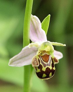
Noar Hill is noted for its calcicoles (chalk-dwelling plants). These include hairy rock-cress ( Arabis hirsuta ), dropwort ( Filipendula vulgaris ), harsh downy-rose ( Rosa tomentosa ), pale flax ( Linum bienne ), common milkwort ( Polygala vulgaris ), marjoram ( Origanum vulgare ), wild thyme (two species: large thyme ( Thymus pulegioides ) and mother-of-thyme ( Thymus polytrichus )), eyebright ( Euphrasia nemorosa ), and clustered bellflower ( Campanula glomerata ).

Small-leaved sweet-briar ( Rosa agrestis ) was recorded in 1978. Four bushes of box ( Buxus sempervirens ) growing on the landslip are considered by Dr Francis Rose to be native. Early gentian ( Gentianella anglica ) has been found (1951, 1988, 1994) on the bare chalk-scree. The parasitic knapweed broomrape (Orobanche elatior) is regularly recorded. Juniper ( Juniperus communis ) thrives; and in spring there is a beautiful display of cowslip ( Primula veris ).

There are occasional findings of dragon's-teeth ( Tetragonolobus maritimus ) and fern-grass ( Catapodium rigidum ).

However, the chief glory of Noar Hill derives from its orchids. At least eleven species have been identified:

Bee orchid Ophrys apifera flower1.jpg
Bee orchid
  1. Twayblade (Neottia ovata)
  2. Autumn lady's tresses (Spiranthes spiralis)
  3. Musk orchid (Herminium monorchis) [7]
  4. Pyramidal orchid (Anacamptis pyramidalis)
  5. Fragrant orchid (Gymnadenia conopsea, including × Dactylodenia st-quintinii)
  6. Frog orchid Coeloglossum viride, including × Dactyloglossum mixtum)
  7. Common spotted orchid (Dactylorhiza fuchsii)
  8. Southern marsh orchid (D. praetermissa)
  9. Early purple orchid (Orchis mascula)
  10. Fly orchid ( Ophrys insectifera )
  11. Bee orchid ( Ophrys apifera )

The colony of musk orchids runs to approximately 10,000 spikes and is of national importance.

High Common, surrounded by botanically impoverished farmland, provides both a refuge for chalk downland species and a reservoir from which recolonization of nearby areas is possible. The habitat restoration being undertaken at Selborne Common may be one beneficiary.

Fauna

Noar Hill is home to the only British species of the curious fairy shrimp (Chirocephalus diaphanus), which lives in puddles on the tracks and survives as an egg when the mud dries. Glow-worms ( Lampyris noctiluca ) are occasionally seen over the reserve on summer evenings. Grasshoppers abound, including the rufous grasshopper (Gomphocerippus rufus).

The butterflies include marbled white (Melanargia galathea), brown argus (Aricia agestis), Duke of Burgundy (Hamearis lucina), brown hairstreak (Thecla betulae), and holly blue (Celastrina argiolus), besides large numbers of more common species.

The reserve is a good place to look for slowworms (Anguis fragilis). It supports breeding turtle doves (Streptopelia turtur); and green woodpeckers (Picus viridis), which are fond of feeding on ants, are frequent. Several pairs of common buzzards (Buteo buteo) are resident in the area and the rabbits on High Common are a favourite prey. The hen harrier Circus cyaneus is an occasional winter visitor. For some reason perhaps the abundance of rosehips bullfinches (Pyrrhula pyrrhula) are always to be found upon the hill.

Notes

  1. 1 2 3 4 "Designated Sites View: Noar Hill". Sites of Special Scientific Interest. Natural England. Retrieved 16 May 2020.
  2. "Map of Noar Hill". Sites of Special Scientific Interest. Natural England. Retrieved 16 May 2020.
  3. Ratcliffe, Derek, ed. (1977). A Nature Conservation Review. Vol. 2. Cambridge, UK: Cambridge University Press. pp. 52–53, 129. ISBN   0521-21403-3.
  4. "Designated Sites View: East Hampshire Hangers". Special Areas of Conservation. Natural England. Retrieved 23 April 2020.
  5. "Noar Hill". Hampshire and Isle of Wight Wildlife Trust. Retrieved 25 April 2020.
  6. White, Gilbert. "Letter I to Thomas Pennant" in Natural History of Selborne
  7. "Herminium monorchis, Musk Orchid".

Related Research Articles

<span class="mw-page-title-main">Selborne Common</span>

Selborne Common is a 99.6-hectare (246-acre) biological Site of Special Scientific Interest west of Selborne in Hampshire. It is a Nature Conservation Review site, Grade I, and is part of the East Hampshire Hangers Special Area of Conservation. It is managed by the National Trust.

<span class="mw-page-title-main">Hartslock</span> Wood and nature reserve in Oxfordshire, UK

Hartslock, also known as Hartslock Woods, is a 41.8-hectare (103-acre) biological Site of Special Scientific Interest (SSSI) in a wooded area on the north bank of the River Thames to the south-east of Goring-on-Thames in the English county of Oxfordshire. An area of 29.4 hectares is a Special Area of Conservation and an area of 10 hectares is a nature reserve owned and managed by the Berkshire, Buckinghamshire and Oxfordshire Wildlife Trust (BBOWT). The site is well known for the variety of wild orchids that grow on its sloping grassland, and especially for the monkey orchid that grows in very few other places in England.

<span class="mw-page-title-main">West Yatton Down</span>

West Yatton Down is a 14.4 hectare biological Site of Special Scientific Interest in Wiltshire, notified in 1971.

<span class="mw-page-title-main">Morgan's Hill</span>

Morgan's Hill is a 12.6-hectare (31-acre) biological Site of Special Scientific Interest between Calne and Devizes in Wiltshire, England. The SSSI was notified in 1951 and again in 1987.

<span class="mw-page-title-main">Pewsey Downs</span>

Pewsey Downs is a 305.3 hectare biological Site of Special Scientific Interest on the southern edge of the Marlborough Downs north of Pewsey in Wiltshire, notified in 1951. It includes the Pewsey Downs National Nature Reserve.

<span class="mw-page-title-main">Ham Hill, Wiltshire</span> Area of chalk downland in Wiltshire, England

Ham Hill is a hill and area of chalk downland in Wiltshire, England, on the steep banks running alongside the road from the village of Ham to Buttermere, close to the Berkshire border. A biological Site of Special Scientific Interest, notified in 1971, covers 1.5 hectares of the site; this designation is due to the site's species-rich plant and insect communities, which include some rare species. Notable among these is the musk orchid, which has been confirmed at only one other site in Wiltshire.

NVC community CG2 is one of the calcicolous grassland communities in the British National Vegetation Classification system. It is one of three short-sward communities associated with heavy grazing, within the lowland calcicolous grassland group, and is regarded as "typical" chalk grassland.

<span class="mw-page-title-main">Barnsley Warren</span> Biological Site of Special Scientific Interest in Gloucestershire, England

Barnsley Warren is a 61.3-hectare (151-acre) biological Site of Special Scientific Interest in Gloucestershire, notified in 1954 and renotified in 1984. The site is also included in A Nature Conservation Review. It lies in a steep-sided dry valley, east of the A429, northeast of Cirencester in the Cotswolds. The site is listed in the 'Cotswold District' Local Plan 2001-2011 as a Key Wildlife Site (KWS).

<span class="mw-page-title-main">Park Gate Down</span>

Park Gate Down or Parkgate Down is a 7-hectare (17-acre) biological Site of Special Scientific Interest south-east of Stelling Minnis in Kent. It is also a Special Area of Conservation and is managed by the Kent Wildlife Trust,

<span class="mw-page-title-main">Burham Down</span>

Burham Down is a 110-hectare (270-acre) nature reserve between Maidstone and Chatham in Kent. It is managed by the Kent Wildlife Trust. It is part of the Wouldham to Detling Escarpment Site of Special Scientific Interest and Nature Conservation Review site, Grade I, the Kent Downs Area of Outstanding Natural Beauty, and the North Downs Woodlands Special Area of Conservation.

The Folkestone Downs are an area of chalk downland above Folkestone, where the eastern end of the North Downs escarpment meets the English Channel. Part of the Downs is the Folkestone to Etchinghill Escarpment Site of Special Scientific Interest, designated for its geological and biological interest.

<i>Herminium monorchis</i> Species of orchid

Herminium monorchis, the musk orchid, is a commonly occurring species of orchid. It is widespread across much of Europe and northern Asia from France to Japan, including China, Siberia, Mongolia, Ukraine, Germany, Italy, Scandinavia, etc.

<span class="mw-page-title-main">St Catherine's Hill, Hampshire</span> Iron Age hillfort in Hampshire, England

St. Catherine's Hill is a chalk downland hill and 43-hectare (110-acre) biological Site of Special Scientific Interest on the outskirts of Winchester in Hampshire, England. It is owned by Winchester College but open to the public. It is managed by Hampshire and Isle of Wight Wildlife Trust, and topped by an Iron Age hillfort, a scheduled monument. In the Black Death, plague pits were dug in the dry valley on the south side of the hill. In the Early modern period, a mizmaze was cut on the hilltop. Winchester College football used to be played on the hill; in an old custom, members of the college assemble on the hill every year, early in the morning.

<span class="mw-page-title-main">Totternhoe Knolls</span>

Totternhoe Knolls is a 13.1-hectare (32-acre) Site of Special Scientific Interest (SSSI) in Totternhoe in Bedfordshire. It is also a local nature reserve, and part of the Chilterns Area of Outstanding Natural Beauty. The site is owned by Central Bedfordshire Council and leased to the National Trust. Most of the site is maintained jointly by the National Trust and the Wildlife Trust for Bedfordshire, Cambridgeshire and Northamptonshire (WTBCN), and is part of the WTBCN Totternhoe nature reserve, which also includes Totternhoe Chalk Quarry and Totternhoe Stone Pit. The SSSI also includes Totternhoe Castle, the earthworks of a Norman motte-and-bailey castle which is a Scheduled monument.

NVC community CG5 is one of the calcicolous grassland communities in the British National Vegetation Classification system. It is one of four communities of rank, tussocky grassland associated with low levels of grazing, within the lowland calcicolous grassland group.

<span class="mw-page-title-main">Deacon Hill SSSI</span> Protected area in Bedfordshire, England

Deacon Hill SSSI is a 35.4-hectare (87-acre) biological Site of Special Scientific Interest in Pegsdon in Bedfordshire. It is in the Chilterns Area of Outstanding Natural Beauty, and it is part of the Pegsdon Hills and Hoo Bit nature reserve, managed by Wildlife Trust for Bedfordshire, Cambridgeshire and Northamptonshire.

<span class="mw-page-title-main">Hampshire Downs</span>

The Hampshire Downs form a large area of downland in central southern England, mainly in the county of Hampshire but with parts in Berkshire and Wiltshire. They are part of a belt of chalk downland that extends from the South Downs in the southeast, north to the Berkshire and Marlborough Downs, and west to the Dorset Downs.

<span class="mw-page-title-main">East Hampshire Hangers</span> Line of hills in Hampshire, England

The East Hampshire Hangers are located in the English county of Hampshire and form a line of hills with steep scarps that marks the eastern edge of the Hampshire Downs and its boundary with the Western Weald, an area of rolling countryside east of Petersfield and Liss. The Hangers run from the area of Farnham to Petersfield, before swinging eastwards to take in the north-facing scarp of the South Downs. The main settlements of the area are the villages of Selborne, Hawkley and East Worldham. The name is derived from the "hangers": long, narrow remnants of ancient woodland clinging to the steep scarp slopes. Examples include Milking Hanger, Warner's Hanger and Wick Hill Hanger.

<span class="mw-page-title-main">Smithcombe, Sharpenhoe and Sundon Hills</span>

Smithcombe, Sharpenhoe and Sundon Hills is an 86.1-hectare (213-acre) Site of Special Scientific Interest in Sharpenhoe in Bedfordshire. Most of it is a National Trust property comprising Sundon Hills, Moleskin and Markham Hills, Sharpenhoe Clappers and Smithcombe Hills. It is part of the Chilterns Area of Outstanding Natural Beauty, and Sharpenhoe Clappers is protected as a Scheduled Ancient Monument.

<span class="mw-page-title-main">Beeding Hill to Newtimber Hill</span>

Beeding Hill to Newtimber Hill is a 321 ha (790-acre) biological and geological Downland Site of Special Scientific Interest (SSSI) north of Shoreham-by-Sea in West Sussex. It is a Nature Conservation Review site, Grade 2, and it includes Devil's Dyke Geological Conservation Review site.

References

51°04′48″N0°56′28″W / 51.080°N 0.941°W / 51.080; -0.941