Geology and ecology
Woolmer Forest straddles two upland watersheds, that of the River Wey and that of the River Rother. In its sandy soil, streams have cut wide valleys into the gently undulating terrain. On upland sites, dry heath predominates, characterised by heather Calluna vulgaris and bell heather Erica cinerea . The driest sandy patches support some well-adapted (xeric) uncommon plants. Humid heath, which requires less free-draining subsoils, is characterized by cross-leaved heath Erica tetralix and purple moor-grass Molinia caerulea , which are joined in the wettest valley bottoms by sphagnum moss and carnivorous sundews. These moisture-retaining habitats grade into complex acidic boggy wetlands of hummocks and pools, locally called "mires". Here are the largest populations in England of the trailing bog cranberry Vaccinium oxycoccos .
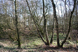
Centuries of forest management have shaped the surrounding belts of woodland, composed notably of beech Fagus sylvatica and pedunculate oak Quercus robur . Repeated pollarding has shaped the growth patterns of centuries-old trees. The discontinuous canopy favours a diverse understory, dominated by holly Ilex aquifolium , whitebeam Sorbus aria and rowan S. aucuparia with birches.
The absence of chemicals in the environment is one aspect that has encouraged an unusual diversity of insects and other invertebrates.
The landscape of Woolmer Forest has been classified by the South Downs National Park Authority, in its integrated landscape character assessment of the park, as falling within the Wealden farmland and heath mosaic, namely a landscape that has developed on the sandstones of the Folkestone Beds (part of the Lower Greensand formation of the Lower Cretaceous). This geology has given rise to a well-drained, sandy lowland landscape supporting a mosaic of oak-birch woodland, conifer plantations, open sandy heaths, and rough grazed pastures. The park authority claims that Woolmer Forest is the best area of lowland heath outside the New Forest, and that it is the largest area of heathland existing on the Folkestone Beds in southern England. [7]
History
Deforestation during the local Bronze Age stripped the natural woodland that had replaced tundra following the retreat of glaciation, and on this light soil the forest cover was replaced with heath. [8] With the settled Roman occupation, the Roman road that was constructed between Chichester and Silchester passed through Woolmer. Traces of Roman villas have been discovered at Blackmoor, Kingsley and Liss, though ordinary people continued to live in roundhouses. Kilns for a pottery industry that apparently supplied Londinium with its cookware [9] must have continued the deforestation to fire the kilns. An extraordinary find, the Blackmoor hoard, consisted of 29,773 coins whose minting dated the hoard to ca 296 CE; in a battle in that year the troops under Emperor Constantius Chlorus defeated the army of the usurper Allectus to retake control of Britain. The hoard may have been the paychest for Allectus's troops secreted and inadvertently abandoned after their defeat. [9]
Following the Roman withdrawal and the collapse of Romano-British culture, the first mention of the present toponym, as Wulfamere, the "wolves' pool", is a token either of reforestation of the landscape or a translation of a previous pre-Roman name.
In the eighteenth century "Wolmer" often appears in Gilbert White's The Natural History and Antiquities of Selborne (1789), as it was included with Selborne parish. White noted that its soil consisted of sand covered with heath and fern, "without having one standing tree in the whole extent." [10] Its bogs had formerly abounded with "subterranean trees", both blackened bog wood, used locally in house construction. In White's day the formerly plentiful Black Grouse were locally extinct, and the red deer, of which the poaching had occasioned the severities of the Black Act, had been rounded up and carted to Windsor. [10]
Only a "narrow range of enclosures" in Gilbert White's day separated the Royal Forest of "Wolmer" from Alice Holt Forest, situated on a loamy soil that – in stark contrast to Woolmer – produced dense stands of oak, and indeed during the late medieval period the two forests were jointly administered.
In 1897 the Guildford Natural History Society presented a petition to the Commissioner of Woods and Forests, to effect "that Wolmer Forest may be reserved as a sanctuary for wild birds." This petition was the result of a lecture by Mr. T. Whitburn, the then president of the Society on Wolmer Forest. The petition asked that the nests and eggs of the birds "may remain unmolested throughout the year; that it may not be let at any time for game preserving, or for any purpose inimical to bird life; and that it may remain in perpetuity as a national memorial to the greatest outdoor naturalist England has produced–Gilbert White, of Selborne." [11]
Statutory designations
The Woolmer Forest Site of Special Scientific Interest (SSSI) was first notified, in respect of Woolmer Forest itself, in 1971; Conford Moor in the east was notified in 1959, and Blackmoor in the west in 1979. These areas were later renotified under the Wildlife and Countryside Act 1981 in 1986, 1984 and 1985 respectively. The SSSI covers 1,293.93 hectares (3,197.4 acres). The SSSI citation notes that Woolmer Forest contains the largest and most diverse area of lowland heathland in Hampshire, outside the New Forest, and that it is considered to be the most important area of heathland in the Weald of southern England.
The Woolmer Forest Special Area of Conservation (SAC) was designated in April 2005 and covers 666.68 hectares (1,647.4 acres). Its main habitats are heath (62%), coniferous woodland (22%) and dry grassland (10%). Its most important features are the dystrophic areas of open water, in particular Cranmer Pond, a shallow 8 hectares (20 acres) pool thought to have been created by peat cutting, and Woolmer Pond; and large extents of European dry heaths. In both cases the area is considered one of the best in the UK. In addition, the SAC supports a significant presence of North Atlantic wet heaths with Erica Tetralix, and transition mires and quaking bogs.
In relation to its dry heaths, Woolmer Forest is the only site in Britain that supports all six native reptiles (including the sand lizard Lacerta agilis and smooth snake Coronella austriaca) and all six native amphibians (including the great crested newt Triturus cristatus). It also supports an outstanding invertebrate fauna and bird assemblage, including European nightjar Caprimulgus europaeus, wood lark Lullula arborea, Dartford warbler Sylvia undata, Eurasian hobby Falco subbuteo, hen harrier Circus cyaneus and merlin Falco columbarius. [12]
Woolmer Forest is also protected by the Wealden Heaths Phase 2 Special Protection Area, covering 2,053.83 hectares (5,075.1 acres), which was designated in March 1993 because of the presence of the rare heathland bird populations noted above such as Dartford warbler and European nightjar.

Ashdown Forest is an ancient area of open heathland occupying the highest sandy ridge-top of the High Weald Area of Outstanding Natural Beauty. It is situated some 30 miles (48 km) south of London in the county of East Sussex, England. Rising to an elevation of 732 feet (223 m) above sea level, its heights provide expansive vistas across the heavily wooded hills of the Weald to the chalk escarpments of the North Downs and South Downs on the horizon.

Chobham Common is a 655.7-hectare (1,620-acre) biological Site of Special Scientific Interest north of Chobham in Surrey. It is a Nature Conservation Review site, Grade I and a national nature reserve. It is part of the Thames Basin Heaths Special Protection Area and the Thursley, Ash, Pirbright and Chobham Special Area of Conservation. It contains three scheduled monuments. Most of the site is managed by the Surrey Wildlife Trust as the Chobham Common nature reserve, but the SSSI also includes a small private reserve managed by the Trust, Gracious Pond.

Holt Heath is a 4.88 square kilometres (1.88 sq mi) common situated four miles north-east of Wimborne Minster in east Dorset, southern England, close to the village of Holt. The reserve includes dry and wet heathland, bog and ancient woodland. The common has several nature conservation designations: national nature reserve, Special Protection Area, Special Area of Conservation and Site of Special Scientific Interest. It is owned by the National Trust and managed in association with Natural England. The heath is one of the few places where all six native British reptile species occur, and it also supports many other heathland animals, plants and birds. Rare heathland birds such as Eurasian Hobby, nightjar, Dartford warbler and woodlark have been recorded as breeding on the reserve.

Breckland in Norfolk and Suffolk is a 39,433 hectare Special Protection Area (SPA) under the European Union Directive on the Conservation of Wild Birds. The SPA partly overlaps the 7,544 hectare Breckland Special Area of Conservation. As a landscape region it is an unusual natural habitat of England. It comprises the gorse-covered sandy heath that lies mostly in the south of the county of Norfolk but also in the north of Suffolk. An area of considerable interest for its unusual flora and fauna, it lies to the east of another unusual habitat, the Fens, and to the south west of the Broads. The typical tree of this area is the Scots pine. Breckland is one of the driest areas in England.

Broadmoor to Bagshot Woods and Heaths is a 1,696.3-hectare (4,192-acre) biological Site of Special Scientific Interest (SSSI) in Berkshire and Surrey that extend from a minority of the parish of Crowthorne including around Broadmoor Hospital in the west to Bagshot south-east, Bracknell north-east, and Sandhurst, south. It is part of the Thames Basin Heaths Special Protection Area. Two nature reserves which are managed by the Surrey Wildlife Trust are in the SSSI, Barossa nature reserve and Poors Allotment. Broadmoor Bottom, which is part of Wildmoor Heath, also falls within the SSSI; this reserve is managed by the Berkshire, Buckinghamshire and Oxfordshire Wildlife Trust.

Colony Bog and Bagshot Heath is a 1,130.5-hectare (2,794-acre) biological Site of Special Scientific Interest between Camberley and Woking in Surrey, England. Part of it is a Nature Conservation Review site, Grade I. It is part of the Thames Basin Heaths Special Protection Area and the Thursley, Ash, Pirbright and Chobham Special Area of Conservation. It includes Brentmoor Heath, a Local Nature Reserve which is managed by the Surrey Wildlife Trust

Icklingham is a village and civil parish in the West Suffolk district of Suffolk in eastern England. It is located about 7 miles (11 km) north-west of Bury St Edmunds, 4 miles (6.4 km) south-east of Mildenhall and 9 miles (14 km) south-west of Thetford in Norfolk. The village is on the A1101 road between Bury St Edmunds and Mildenhall in the north-west of the county. The area around the village, characterised by a sandy gravel-laden soil, is known as Breckland, though an arm of the fen-like peat follows the River Lark past the village.
Thursley Common is a national nature reserve in Surrey, England, and has also been designated as a Ramsar wetland. It is also part of a Site of Special Scientific Interest called Thursley, Hankley and Frensham Commons.
Lowland heath is a Biodiversity Action Plan habitat as it is a type of ancient wild landscape. Natural England's Environmental Stewardship scheme describes lowland heath as containing dry heath, wet heath and valley mire communities, usually below 250 metres (820 ft) in altitude, on acidic soils and shallow peat, typically comprising heathers, gorses, fine grasses, wild flowers and lichens in a complex mosaic. Heathers and other dwarf shrubs usually account for at least 25% of the ground cover. By contrast, upland heath, which is above 300 metres (980 ft) in altitude, is called moorland, Dartmoor being an example.
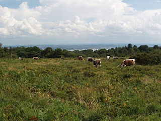
The western Weald is an area of undulating countryside in Hampshire and West Sussex containing a mixture of woodland and heathland areas.

Sandhurst to Owlsmoor Bogs and Heaths is an 85.8-hectare (212-acre) biological Site of Special Scientific Interest (SSSI) on the northern outskirts of Sandhurst in Berkshire. Part of the SSSI is Wildmoor Heath nature reserve, which is managed by the Berkshire, Buckinghamshire and Oxfordshire Wildlife Trust. and the SSSI is part of Thames Basin Heaths Special Protection Area.
Sound Heath, also known as Sound Common, is an area of common land in Sound, near Nantwich in Cheshire, England, which includes heathland, grassland, scrub, woodland and wetland habitats. The majority of the area is designated a Site of Special Scientific Interest and a Local Nature Reserve.

Ashdown Forest, a former royal hunting forest situated some 30 miles south-east of London, is a large area of lowland heathland whose ecological importance has been recognised by its designation as a UK Site of Special Scientific Interest and by the European Union as a Special Protection Area for birds and a Special Area of Conservation for its heathland habitats, and by its membership of Natura 2000, which brings together Europe's most important and threatened wildlife areas.

Rosenannon Downs is a nature reserve in mid Cornwall, England, UK, being designated Rosenannon Bog and Downs Site of Special Scientific Interest (SSSI), noted for its biological characteristics. The site supports a wide variety of flora and fauna and includes Bronze Age barrows. Conservation work is carried out on the site by the owners, the Cornwall Wildlife Trust.

Blaxhall Common is a nature reserve in the parish of Blaxhall in the East Suffolk District of Suffolk. The reserve is owned by Blaxhall Parish Council and managed by Suffolk Wildlife Trust. It is designated a 45.9-hectare (113-acre) biological Site of Special Scientific Interest as Blaxhall Heath. It is part of the Sandlings Special Protection Area under the European Union Directive on the Conservation of Wild Birds, and of the Suffolk Coast and Heaths Area of Outstanding Natural Beauty. A Bronze Age bowl barrow is a Scheduled Monument.

Kingsley Common is a 41-hectare (100-acre) protected area in Kingsley, Hampshire, England. The site holds many rare species of animals and birds. Some species of plants and animals may also be subject to special protection under Part I of the Wildlife and Countryside Act 1981, or under the Habitats Regulations 1994.
Poor's Allotment is a 28.57-hectare (70.6-acre) biological Site of Special Scientific Interest in Gloucestershire, notified in 1954. The site is listed in the 'Forest of Dean Local Plan Review' as a Key Wildlife Site (KWS).

Hartland Moor is a Site of Special Scientific Interest (SSSI) on the south side of Poole Harbour near the town of Wareham in Dorset, England. It consists of lowland heathland.

Thetford Heaths is a 270.6-hectare (669-acre) biological and geological Site of Special Scientific Interest in Suffolk. It is a Nature Conservation Review site, Grade I, and parts of it are a national nature reserve, and a Geological Conservation Review, It is part of the Breckland Special Area of Conservation, and Special Protection Area A large part of this dry heathland site is calcareous grassland, and some areas are grazed by sheep or rabbits. There are several nationally rare plants and an uncommon heathland bird, and many lichens and mosses.

Tadnoll and Winfrith Heath is a nature reserve of the Dorset Wildlife Trust, near the village of Winfrith Newburgh in Dorset, England. There is heathland and wetland in the reserve.
