Turners Hill SSSI

Last updated
Turners Hill SSSI
Site of Special Scientific Interest
Turner's Hill SSSI (2).jpg
Area of Search West Sussex
Grid reference TQ 338 354 [1]
InterestGeological
Area0.2 hectares (0.49 acres) [1]
Notification 1999 [1]
Location map Magic Map

Turners Hill SSSI is a 0.2-hectare (0.49-acre) geological Site of Special Scientific Interest in Turners Hill in West Sussex. [1] [2] It is a Geological Conservation Review site. [3]

Site of Special Scientific Interest Conservation designation denoting a protected area in the United Kingdom

A Site of Special Scientific Interest (SSSI) in Great Britain or an Area of Special Scientific Interest (ASSI) in the Isle of Man and Northern Ireland is a conservation designation denoting a protected area in the United Kingdom and Isle of Man. SSSI/ASSIs are the basic building block of site-based nature conservation legislation and most other legal nature/geological conservation designations in the United Kingdom are based upon them, including national nature reserves, Ramsar sites, Special Protection Areas, and Special Areas of Conservation. The acronym "SSSI" is often pronounced "triple-S I".

Turners Hill village and civil parish in the Mid Sussex District of West Sussex, England

Turners Hill is a village and civil parish in the Mid Sussex District of West Sussex, England. The civil parish covers an area of 1,390 hectares, and has a population of 1,849 increasing to 1,919 at the 2011 Census.

West Sussex County of England

West Sussex is a county in the south of England, bordering East Sussex to the east, Hampshire to the west and Surrey to the north, and to the south the English Channel.

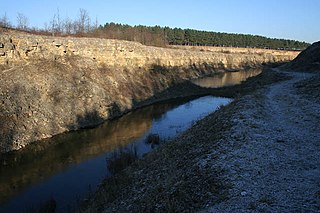
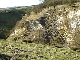
This former quarry exposed the Tunbridge Wells Sand Formation, part of the Hastings Beds, which dates to the Early Cretaceous between about 140 and 100 million years ago. It provided excellent three dimensional sections through the Ardingly Sandstone Member of the Formation. [4]

The Tunbridge Wells Sand Formation is a geological unit which forms part of the Wealden Group and the uppermost and youngest part of the unofficial Hastings Beds. These geological units make up the core of the geology of the Weald in the English counties of West Sussex, East Sussex and Kent.

The Hastings Beds is a geological unit that includes interbedded clays, silts, siltstones, sands and sandstones in the High Weald of southeast England. These strata make up the component geological formations of the Ashdown Formation, the Wadhurst Clay Formation and the Tunbridge Wells Sand Formation. The term 'Hastings Beds' has been superseded and the component formations are included in the Wealden Group.

The Early Cretaceous or the Lower Cretaceous, is the earlier or lower of the two major divisions of the Cretaceous. It is usually considered to stretch from 146 Ma to 100 Ma.

The site is private land with no public access. The quarry has been filled in and no geology is visible.

Related Research Articles

Seale Chalk Pit

Seale Chalk Pit is a 1.2-hectare (3.0-acre) geological Site of Special Scientific Interest west of Guildford in Surrey. It is a Geological Conservation Review site and part of the Seale Chalk Pit and Meadow 3-hectare (7.4-acre) private nature reserve, which is managed by the Surrey Wildlife Trust.

Stockstone Quarry

Stockstone Quarry is a 3.9-hectare (9.6-acre) geological Site of Special Scientific Interest south of Farnham in Surrey. It is a Geological Conservation Review site.

Westwood Quarry human settlement in United Kingdom

Westwood Quarry is a 0.07 hectare geological site of Special Scientific Interest west of Watford in Hertfordshire. It was notified in 1987 under the Wildlife and Countryside Act 1981. The planning authority is Three Rivers District Council. It is a Geological Conservation Review site.

Asham Quarry human settlement in United Kingdom

Asham Quarry is a 2.6-hectare (6.4-acre) geological Site of Special Scientific Interest north of Newhaven in East Sussex. It is a Geological Conservation Review site and in the Sussex Downs Area of Outstanding Natural Beauty.

Blackhorse Quarry

Blackhorse Quarry is a 0.2-hectare (0.49-acre) geological Site of Special Scientific Interest south-east of Battle in East Sussex. It is a Geological Conservation Review site.

Northiam SSSI

Northiam SSSI is a 0.3-hectare (0.74-acre) geological Site of Special Scientific Interest in Northiam in East Sussex. It is a Geological Conservation Review site.

West Hoathly SSSI human settlement in United Kingdom

West Hoathly SSSI is a 0.7-hectare (1.7-acre) geological Site of Special Scientific Interest in Sharpthorne in West Sussex. It is a Geological Conservation Review site.

Allington Quarry

Allington Quarry is a 0.8-hectare (2.0-acre) geological Site of Special Scientific Interest north of Maidstone in Kent. It is a Geological Conservation Review site.

Moor Mill Quarry, West

Moor Mill Quarry, West is a 0.16 hectare geological Site of Special Scientific Interest in How Wood in Hertfordshire. The local planning authority is St Albans City and District Council. It was notified in 1992 as representing the former Moor Mill Quarry SSSI, which was lost to landfill operations. It is listed by the Geological Conservation Review.

Bardon Hill Quarry

Bardon Hill Quarry is a 58.2 hectare geological Site of Special Scientific Interest east of Coalville in Leicestershire. It is a Geological Conservation Review site.

Sproxton Quarry

Sproxton Quarry is a 5.4 hectares geological Site of Special Scientific Interest north-east of Sproxton in Leicestershire. It is a Geological Conservation Review site.

Cliffe Hill Quarry

Cliffe Hill Quarry is a 19.2 hectares geological Site of Special Scientific Interest on the western outskirts of Markfield in Leicestershire. It is a Geological Conservation Review site.

Lenham Quarry

Lenham Quarry is a 4-hectare (9.9-acre) geological Site of Special Scientific Interest east of Lenham in Kent. It is a Geological Conservation Review site.

Houlder and Monarch Hill Pits, Upper Halling

Houlder and Monarch Hill Pits is a 0.7-hectare (1.7-acre) geological Site of Special Scientific Interest in Upper Halling in Kent. It is a Geological Conservation Review site.

Scaynes Hill SSSI

Scaynes Hill is a 0.04-hectare (0.099-acre) geological Site of Special Scientific Interest north-west of Newick in East Sussex. It is a Geological Conservation Review site.

Slinfold Stream and Quarry Site of Special Scientific Interest

Slinfold Stream and Quarry is a 2.3-hectare (5.7-acre) geological Site of Special Scientific Interest west of Horsham in West Sussex. It is a Geological Conservation Review site.

Bognor Common Quarry

Bognor Common Quarry is a 25.1-hectare (62-acre) geological Site of Special Scientific Interest east of Petworth in West Sussex. It is a Geological Conservation Review site.

Freshfield Lane

Freshfield Lane is a 17-hectare (42-acre) geological Site of Special Scientific Interest east of Haywards Heath in West Sussex. It is a Geological Conservation Review site.

References

  1. 1 2 3 4 "Designated Sites View: Turners Hill". Sites of Special Scientific Interest. Natural England. Retrieved 6 May 2019.
  2. "Map of Turners Hill". Sites of Special Scientific Interest. Natural England. Retrieved 6 May 2019.
  3. "Turners Hill (Wealden)". Geological Conservation Review. Joint Nature Conservation Committee. Retrieved 6 April 2019.
  4. "Turners Hill citation" (PDF). Sites of Special Scientific Interest. Natural England. Retrieved 6 May 2019.

Coordinates: 51°06′07″N0°05′24″W / 51.102°N 0.090°W / 51.102; -0.090

Geographic coordinate system Coordinate system

A geographic coordinate system is a coordinate system that enables every location on Earth to be specified by a set of numbers, letters or symbols. The coordinates are often chosen such that one of the numbers represents a vertical position and two or three of the numbers represent a horizontal position; alternatively, a geographic position may be expressed in a combined three-dimensional Cartesian vector. A common choice of coordinates is latitude, longitude and elevation. To specify a location on a plane requires a map projection.