
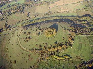
Danebury is an Iron Age hillfort in Hampshire, England, about 19 kilometres (12 mi) north-west of Winchester. The site, covering 5 hectares, was excavated by Barry Cunliffe in the 1970s. Danebury is considered a type-site for hill forts, and was important in developing the understanding of hillforts, as very few others have been so intensively excavated.

Cissbury Ring is an 84.2-hectare (208-acre) biological Site of Special Scientific Interest north of Worthing in West Sussex. It is owned by the National Trust and is designated a Scheduled monument for its Neolithic flint mine and Iron Age hillfort.

Chanctonbury Hill is an 82.7-hectare (204-acre) biological Site of Special Scientific Interest west of Steyning in West Sussex. Part of it is Chanctonbury Ring, an early Iron Age hillfort which contains two Romano-Celtic temples and which is a Scheduled Monument.

Whitehorse Hill is a hill in the Berkshire Downs in Oxfordshire, England, west of Wantage. At 261 metres (856 ft), it is the highest point in Oxfordshire. Uffington Castle lies on the summit of the hill, and the Uffington White Horse is on the hill's northern slope. The hill and an adjacent area below, including Dragon Hill and The Manger, make up a 98.9-hectare (244-acre) biological and geological Site of Special Scientific Interest.

Cley Hill is a prominent hill to the west of Warminster in Wiltshire, England. Its summit has a commanding view of the Wiltshire / Somerset county boundary, at 244 metres (801 ft) elevation. The land is in Corsley parish and is owned by the National Trust.

Old Winchester Hill is a 66.2-hectare (164-acre) biological Site of Special Scientific Interest in Hampshire. It is a Nature Conservation Review site, Grade I, and a national nature reserve. Part of it is a scheduled monument.

Puttenham and Crooksbury Commons is a 113.8-hectare (281-acre) biological Site of Special Scientific Interest between Farnham and Guildford in Surrey. Puttenham Common is owned by the Hampton Estate and managed on behalf of Surrey County Council. Hillbury Hillfort on Puttenham Common is a scheduled monument. It is a univallate hillfort which probably dates to the Iron Age.
St. Catherine's Hill is a chalk downland hill and 43-hectare (110-acre) biological Site of Special Scientific Interest on the outskirts of Winchester in Hampshire. It is owned by Winchester College but open to the public. It is managed by Hampshire and Isle of Wight Wildlife Trust, and most of it is an Iron Age hillfort, which is a Scheduled Monument.

Lewes Downs is a 165-hectare (410-acre) biological Site of Special Scientific Interest east of Lewes in East Sussex. It is a Nature Conservation Review site, Grade I and a Special Area of Conservation. Part of it is a national nature reserve, part is Malling Down nature reserve, which is managed by the Sussex Wildlife Trust, and part is Mount Caburn, an Iron Age hill fort which is a Scheduled Monument.

Ladle Hill is a 10.5-hectare (26-acre) biological Site of Special Scientific Interest west of Kingsclere in Hampshire. It is also a Scheduled Monument.
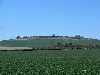
Quarley Hill is the site of an Iron Age univallate hill fort in Hampshire, southern England. The hill affords commanding views of the surrounding countryside.

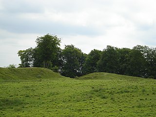
Scratchbury Camp is the site of an Iron Age univallate hillfort on Scratchbury Hill, overlooking the Wylye valley about 1 km northeast of the village of Norton Bavant in Wiltshire, England. The fort covers an area of 37 acres (15 ha) and occupies the summit of the hill on the edge of Salisbury Plain, with its four-sided shape largely following the natural contours of the hill.

Portsdown is a 69.1-hectare (171-acre) biological Site of Special Scientific Interest on Portsdown Hill, on the northern outskirts of Portsmouth in Hampshire.

Gomm Valley is a 4.1-hectare (10-acre) biological Site of Special Scientific Interest in Micklefield, a district of High Wycombe in Buckinghamshire. It is managed by the Berkshire, Buckinghamshire and Oxfordshire Wildlife Trust and is part of the Chilterns Area of Outstanding Natural Beauty. The local planning authority is Wycombe District Council.

Grangelands and Pulpit Hill is a 25.5-hectare (63-acre) biological Site of Special Scientific Interest in Cadsden in Buckinghamshire. It lies within the Chilterns Area of Outstanding Natural Beauty, and the planning authorities are Wycombe District Council and Buckinghamshire County Council.

Swyncombe Downs is a 47.1-hectare (116-acre) biological Site of Special Scientific Interest east of Wallingford in Oxfordshire. Part of it is an Iron Age hillfort, Wyfold Castle, which is a Scheduled Monument.

Watlington and Pyrton Hills is a 112.7-hectare (278-acre) biological Site of Special Scientific Interest east of Watlington in Oxfordshire. An area of 1.6 hectares is Watlington Chalk Pit, which is a Local Nature Reserve.
Danebury Hill is a 13.7-hectare (34-acre) biological Site of Special Scientific Interest north-east of Nether Wallop in Hampshire. It is part of Danebury Hillfort Local Nature Reserve.

Stockbridge Down is a 69.8-hectare (172-acre) biological Site of Special Scientific Interest east of Stockbridge in Hampshire. It is a Nature Conservation Review site, Grade 2. It is owned by the National Trust and part of it is a Scheduled Monument, with an Iron Age hillfort and fourteen Bronze Age burial mounds.
