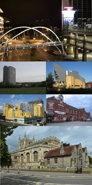
Basingstoke is a town in Hampshire, situated in south-central England across a valley at the source of the River Loddon on the western edge of the North Downs. It is the largest settlement in Hampshire without city status. It is located 30 miles (48 km) north-east of Southampton, 48 miles (77 km) south-west of London, 27 miles (43 km) west of Guildford, 22 miles (35 km) south of Reading and 20 miles (32 km) north-east of the county town and former capital Winchester. According to the 2016 population estimate, the town had a population of 113,776. It is part of the borough of Basingstoke and Deane and part of the parliamentary constituency of Basingstoke.

Basingstoke and Deane is a local government district with borough status in Hampshire, England. The main town is Basingstoke, where the council is based. The district also includes the towns of Tadley and Whitchurch, along with numerous villages and surrounding rural areas. The modern district was created in 1974, initially being called Basingstoke. It changed its name to "Basingstoke and Deane" in 1978 at the same time that it was made a borough; Deane was added to the name to represent the rural parts of the borough, being the area's smallest village.
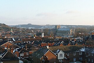
Winchester, or the City of Winchester, is a local government district with city status in Hampshire, England.

Coombe is a historic neighbourhood in the Royal Borough of Kingston upon Thames in south west London, England. It sits on high ground, east of Norbiton. Most of the area was part of the former Municipal Borough of Malden and Coombe before local government re-organisation in 1965. It now shares borders with the boroughs of Merton and Sutton with, to the north, the small, inter-related neighbourhoods of Kingston Hill and Kingston Vale, beyond which is Richmond Park in Richmond; and Roehampton/Putney Vale in Wandsworth. To the east are public playing fields and Wimbledon Common.

Hannington is a civil parish in the English county of Hampshire. It is situated between Basingstoke and Newbury, on the North Hampshire Downs in the North Wessex Downs Area of Outstanding Natural Beauty. In the 2001 census it had a population of 332 people, increasing to 493 at the 2011 Census.

Basingstoke is a constituency in Hampshire represented in the House of Commons of the UK Parliament since 2024 by Luke Murphy, a member of the Labour Party.

Frimley Green is a large village and ward of 580 acres (2.3 km2) in the Borough of Surrey Heath in Surrey, England, approximately 30 mi (48 km) southwest of central London. It is 1 mi (1.6 km) south of the town of Frimley.

Oakley is a village in the borough of Basingstoke and Deane in Hampshire, England, located around 4.5 miles (7 km) west of Basingstoke. In the 2001 Census it had a population of 5,322. Together with the smaller village of Deane, it forms the Oakley and Deane civil parish renamed as Oakley at the 2011 Census.
Ashmansworth is a village and civil parish in the Basingstoke and Deane district of the English county of Hampshire.
One third of Basingstoke and Deane Borough Council in Hampshire, England is elected each year, followed by one year without election. Since the last boundary changes in 2021, 54 councillors have been elected from 18 wards.
Kempshott is a ward of Basingstoke on the western edge of the town, to the south of Pack Lane and north of Winchester Road. The population of the ward at the 2011 Census was 6,827.
Brighton Hill is a district of Basingstoke, England, that was formed around 1970 as part of the Town Centre Development Plan. The area is bounded to the west by the newer housing estate of Hatch Warren and by the A30. To the east of Brighton Hill, the Viables Industrial Estate and Cranbourne area. The area to the east is a lot older than Brighton Hill itself. The M3 motorway runs in a straight line to the south of the area, directly next to the southern ebb of Brighton Hill, which sometimes is referred to as Old Hatchwarren.

Chineham is a civil parish on the outskirts of Basingstoke, Hampshire, England. It is situated about 3 miles (5 km) northeast of central Basingstoke, just north of the A33 road between Basingstoke and Reading.

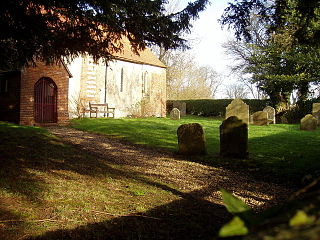
Winslade is a hamlet and civil parish in the Basingstoke and Deane district of Hampshire, England. It lies 3 miles (4.8 km) south of Basingstoke, just off the A339 road. The hamlet covers an area of 712 acres (288 ha) and has an average elevation of 550 feet (170 m). Its nearest railway station is Basingstoke, 4.2 miles (6.8 km) north of the hamlet. The parish of Winslade contains the vast Hackwood Park, an 89-acre (36 ha) Grade I listed Royal deer park. According to the 2011 census, Winslade, along with Tunworth, Weston Corbett and Weston Patrick, had a population of 224.
Stoke is a small village in northwest Hampshire. At the 2011 Census the population of the village was included in the civil parish of St Mary Bourne. It lies in the valley of the Bourne Rivulet, a tributary of the River Test 5 miles (8.0 km) northeast of the town of Andover.

The 2010 Basingstoke and Deane Council election took place on 6 May 2010 to elect members of Basingstoke and Deane Borough Council in Hampshire, England. It was part of the wider English Local Elections, which were postponed from their usual date of the first Thursday of May so that they could coincide with the General Election of that year. One third of the council was up for election and the Conservative Party stayed in overall control of the council.

The 2011 Basingstoke and Deane Council election took place on 5 May 2011 to elect members of Basingstoke and Deane Borough Council in Hampshire, England. One third of the council was up for election and the Conservative Party stayed in overall control of the council.

The 2024 Basingstoke and Deane Borough Council election took place on 2 May 2024 to elect members of Basingstoke and Deane Borough Council in Hampshire, England, alongside other local elections in England and Wales. A third of the council's 54 seats were up for election.

