University, Hillsborough County, Florida

Last updated

University,
Hillsborough County, Florida
Hillsborough County Florida Incorporated and Unincorporated areas University Highlighted.svg
Location in Hillsborough County and the state of Florida
Coordinates: 28°4′11″N82°26′14″W / 28.06972°N 82.43722°W / 28.06972; -82.43722
Country United States
State Florida
County Hillsborough
Area
[1]
  Total6.57 sq mi (17.00 km2)
  Land6.33 sq mi (16.39 km2)
  Water0.23 sq mi (0.61 km2)
Elevation
45 ft (14 m)
Population
 (2020)
  Total50,893
  Density8,039.97/sq mi (3,104.21/km2)
Time zone UTC-5 (Eastern (EST))
  Summer (DST) UTC-4 (EDT)
ZIP Codes
33612 and 33613
Area code 813
FIPS code 12-73163 [2]

University is an unincorporated census-designated place in Hillsborough County, Florida, United States. The population was 41,163 at the 2010 census, [3] up from 30,736 at the 2000 census. The University of South Florida is located just southeast of the community, within the Tampa city limits. The community is also known as "University West", mainly due to its location in relation to the university. The community is often notoriously referred to by locals as "Suitcase City" [4] due to the high rate of transients. [5]

Contents

Description

University is bounded by Interstate 275 to the west, Tampa city limits to the south and east, including the University of South Florida, and Sinclair Hills Road to the north. Its historical boundaries stretch as far east as Morris Bridge Road; however, the boundaries were scaled back owing to annexations by Tampa and Temple Terrace during the 1980s.

Economy

University Mall, a shopping center located at the southern end of the community, was the main source of economic development within the community during the 1970s and '80s. The businesses that were concentrated in the mall have been replaced by many stand-alone shops along Fowler and Fletcher Avenues, such as Wal-Mart, Target and dozens of fast food establishments. There is a county bus transportation center operated by HARTline and a county health department located in the area. Fletcher East has become a hub of medical and dental groups adjacent to Florida Hospital Tampa.

Geography

University is located in northern Hillsborough County at 28°4′11″N82°26′14″W / 28.06972°N 82.43722°W / 28.06972; -82.43722 (28.069644, -82.437091). [6] It is 9 miles (14 km) north of downtown Tampa. The community of Lake Magdalene is to the west, and Lutz is to the north. The CDP includes the area known as Nowatney.

According to the United States Census Bureau, the University CDP has a total area of 6.7 square miles (17.3 km2), of which 6.4 square miles (16.6 km2) are land and 0.2 square miles (0.6 km2), or 3.62%, are water. [3]

Demographics

Historical population
CensusPop.Note
1970 10,039
1980 24,514144.2%
1990 23,760−3.1%
2000 30,73629.4%
2010 41,16333.9%
2020 50,89323.6%
source: [7]

2010 and 2020 census

University (Hillsborough County) racial composition
(Hispanics excluded from racial categories)
(NH = Non-Hispanic)
RacePop 2010 [8] Pop 2020 [9] % 2010% 2020
White (NH)13,81414,22133.56%27.94%
Black or African American (NH)12,69913,67630.85%26.87%
Native American or Alaska Native (NH)108920.26%0.18%
Asian (NH)1,5313,1193.72%6.13%
Pacific Islander or Native Hawaiian (NH)26700.06%0.14%
Some other race (NH)1043810.25%0.75%
Two or more races/Multiracial (NH)8981,9082.18%3.75%
Hispanic or Latino (any race)11,98317,42629.11%34.24%
Total41,16350,893

As of the 2020 United States census, there were 50,893 people, 19,315 households, and 7,190 families residing in the CDP. [10]

As of the 2010 United States census, there were 41,163 people, 17,498 households, and 7,474 families residing in the CDP. [11]

2000 census

As of 2000, there were 13,623 households, out of which 24.9% had children under the age of 18 living with them, 18.1% were married couples living together, 18.4% had a female householder with no husband present, and 57.8% were non-families. 41.7% of all households were made up of individuals, and 7.1% had someone living alone who was 65 years of age or older. The average household size was 2.12 and the average family size was 2.96.

In 2000, in the CDP, the population was spread out, with 22.8% under the age of 18, 22.1% from 18 to 24, 32.5% from 25 to 44, 12.1% from 45 to 64, and 10.5% who were 65 years of age or older. The median age was 27 years. For every 100 females, there were 97.4 males. For every 100 females age 18 and over, there were 94.8 males.

In 2000, the median income for a household in the community was $22,090, and the median income for a family was $24,094. Males had a median income of $22,419 versus $20,219 for females. The per capita income for the community was $13,417. About 24.8% of families and 31.3% of the population were below the poverty line, including 39.6% of those under age 18 and 14.0% of those age 65 or over.

Related Research Articles

<span class="mw-page-title-main">Cheval, Florida</span> Census-designated place in Florida, United States

Cheval is a census-designated place in Hillsborough County, Florida, United States. The population was 10,702 at the 2010 census, up from 7,602 at the 2000 census.

<span class="mw-page-title-main">Citrus Park, Florida</span> Census-designated place in Florida, United States

Citrus Park is an unincorporated census-designated place in Hillsborough County, Florida, United States. The population was 28,178 at the 2020 census, up from 24,252 at the 2010 census.

<span class="mw-page-title-main">East Lake-Orient Park, Florida</span> Census-designated place in Florida, United States

East Lake-Orient Park is an unincorporated census-designated place in Hillsborough County, Florida, United States. The population was 22,753 at the 2010 census, up from 5,703 at the 2000 census following an expansion of its borders. The area is the home of the Florida State Fairgrounds, which hosts the Florida State Fair in mid-February of each year. It was previously home to East Lake Square Mall. The ZIP code for East Lake-Orient Park is 33610 and 33619.

<span class="mw-page-title-main">Lake Magdalene, Florida</span> Census-designated place in Florida, United States

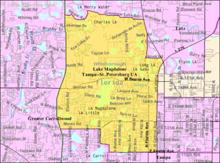
Lake Magdalene is a census-designated place (CDP) in Hillsborough County, Florida, United States. The population was 28,509 at the 2010 census.

<span class="mw-page-title-main">Mango, Florida</span> Census-designated place in Florida, United States

Mango is a census-designated place (CDP) in Hillsborough County, Florida, United States. The population was 11,313 at the 2010 census, up from 8,842 at the 2000 census.

<span class="mw-page-title-main">Palm River-Clair Mel, Florida</span> Census-designated place in Florida, United States

Palm River-Clair Mel is a census-designated place (CDP) in Hillsborough County, Florida, United States. The population was 21,024 at the 2010 census, up from 17,589 at the 2000 census. The census area includes the unincorporated communities of Clair-Mel City and Palm River. The ZIP code for Palm River-Clair Mel is 33619.

<span class="mw-page-title-main">Pebble Creek, Florida</span> Census-designated place in Florida, United States

Pebble Creek is a census-designated place (CDP) in Hillsborough County, Florida, United States. The population was 9,624 at the 2020 census, up from 7,622 at the 2010 census. Pebble Creek is located in the unincorporated portion of New Tampa, and is primarily a residential zone.

<span class="mw-page-title-main">Progress Village, Florida</span> Census-designated place in Florida, United States

Progress Village is a census-designated place (CDP) in Hillsborough County, Florida, United States. Per the 2020 census, the population was 11,188.

<span class="mw-page-title-main">Riverview, Florida</span> Census-designated place in Florida, United States

Riverview is an unincorporated census-designated place in Hillsborough County, Florida, United States. It is located south of Brandon. The population was 107,396 in the 2020 census, up from 71,050 in the 2010 census.

<span class="mw-page-title-main">Town 'n' Country, Florida</span> Census-designated place in Florida, United States

Town 'n' Country is a census-designated place (CDP) in Hillsborough County, Florida, United States. The population was 85,951 at the 2020 census.

<span class="mw-page-title-main">Coral Terrace, Florida</span> Census-designated place in Florida

Coral Terrace is a suburban unincorporated community and census-designated place (CDP) in Miami-Dade County, Florida, United States. It is part of the Miami metropolitan area of South Florida. The population was 23,142 at the 2020 census, down from 24,376 in 2010.

<span class="mw-page-title-main">Leisure City, Florida</span> Census-designated place in Florida

Leisure City is an unincorporated community and census-designated place (CDP) in Miami-Dade County, Florida, United States, that includes the smaller, older community of Modello in its northwestern section. The CDP is most notable for the Coral Castle Museum, located in the Modello area. It is located in the Miami metropolitan area of South Florida. The population was 26,324 at the 2020 census, up from 22,655 in 2010.

<span class="mw-page-title-main">Palm Springs North, Florida</span> Census-designated place in Florida

Palm Springs North is an unincorporated community and census-designated place (CDP) in Miami-Dade County, Florida, United States. It is part of the Miami metropolitan area of South Florida. The population was 5,030 at the 2020 census.

<span class="mw-page-title-main">Palmetto Estates, Florida</span> Census-designated place in Florida

Palmetto Estates is an unincorporated area and census-designated place (CDP) in Miami-Dade County, Florida, United States. It is part of the Miami metropolitan area of South Florida. The population was 13,498 at the 2020 census.

<span class="mw-page-title-main">Sunset, Florida</span> Census-designated place in Florida

Sunset is a census-designated place (CDP) in Miami-Dade County, Florida, United States. It is part of the Miami metropolitan area of South Florida. The population was 15,912 at the 2020 census. The U.S. Postal Service uses the ZIP Codes of 33173 and 33183 for Sunset.

<span class="mw-page-title-main">Tamiami, Florida</span> Census-designated place in Florida

Tamiami is a census-designated place (CDP) in Miami-Dade County, Florida, United States. It is part of the Miami metropolitan area of South Florida. The population was 54,212 at the 2020 census.

<span class="mw-page-title-main">The Crossings, Florida</span> CDP in Florida

The Crossings is a census-designated place (CDP) and suburb of Miami in Miami-Dade County, Florida, United States. It is part of the Miami metropolitan area of South Florida. The CDP includes the neighborhoods of The Crossings, Devon Aire, and Calusa. The population was 23,276 at the 2020 census.

<span class="mw-page-title-main">The Hammocks, Florida</span> Census-designated place in Florida

The Hammocks is a planned community and census-designated place in Miami-Dade County, Florida, United States. It is part of the Miami metropolitan area of South Florida. The population was 59,480 at the 2020 census, up from 51,003 in 2010.

<span class="mw-page-title-main">Three Lakes, Florida</span> Census-designated place in Florida

Three Lakes is a census-designated place (CDP) and planned community in Miami-Dade County, Florida, United States. It is part of the Miami metropolitan area of South Florida. The population was 16,540 at the 2020 census, up from 15,047 in 2010.

<span class="mw-page-title-main">Odessa, Florida</span> CDP in Florida, United States

Odessa is a census-designated place (CDP) in Pasco County, Florida, United States. The population was 3,173 at the 2000 census and more than doubled to 7,267 in 2010. Northwest of Tampa, Odessa had been an area of open spaces, ranching, and horse properties. More recently it has seen many suburban property developments as Tampa's population expands.

References

  1. "2020 U.S. Gazetteer Files". United States Census Bureau. Retrieved December 2, 2021.
  2. "U.S. Census website". United States Census Bureau . Retrieved January 31, 2008.
  3. 1 2 "Geographic Identifiers: 2010 Demographic Profile Data (G001): University CDP (Hillsborough County), Florida". American Factfinder. U.S. Census Bureau. Retrieved May 5, 2017.[ dead link ]
  4. Ambling in a place of many monikers. St Petersburg Times . Retrieved 2011-06-10.]
  5. Suitcase City gets labeled for crime. St Petersburg Times . Retrieved 2011-06-10.]
  6. "US Gazetteer files: 2010, 2000, and 1990". United States Census Bureau. February 12, 2011. Retrieved April 23, 2011.
  7. "CENSUS OF POPULATION AND HOUSING (1790-2000)". U.S. Census Bureau . Retrieved July 17, 2010.
  8. "P2 HISPANIC OR LATINO, AND NOT HISPANIC OR LATINO BY RACE - 2010: DEC Redistricting Data (PL 94-171) - University CDP (Hillsborough County), Florida". United States Census Bureau .
  9. "P2 HISPANIC OR LATINO, AND NOT HISPANIC OR LATINO BY RACE - 2020: DEC Redistricting Data (PL 94-171) - University CDP (Hillsborough County), Florida". United States Census Bureau .
  10. "S1101 HOUSEHOLDS AND FAMILIES - 2020: University CDP (Hillsborough County), Florida". United States Census Bureau .
  11. "S1101 HOUSEHOLDS AND FAMILIES - 2010: University CDP (Hillsborough County), Florida". United States Census Bureau .